
Faroe Islands Aug 10-12 2018
Capital & largest city: Torshavn. 62°00’N 06°47’W
Official languages: Faroese, Danish
Ethnic Groups: Faroe Islanders
Demonym: Faroe Islanders, Faroese
Sovereign state: Kingdom of Denmark
Area: 1,399 km2 (540 sq mi) (unranked). Water 0.5%
Population (2017): 50,778 (206th). Density: 35.2/km²
GDP (PPP): $1.462 billion. Per capita: $33,700
GDP (nominal): 3.09 billion. Per capita: $61,325
Gini: 23.3 low
HDI: .950 very high
Currency: Faroese Krona, DKK. The currency, printed with Faroese motifs, is issued at par with the Danish krone, uses the same sizes and standards as Danish coins and banknotes, and incorporates the same security features. Faroese kronur (singular krona) shares the Danish code DKK.
Value Aug 2018: 10DKK = €1.34 = US$1.54 = CAD2.012
Calling Code: +298
TIPS
1. Currency. The Danish krona had a conversion rate in August 2018: 10 DK = €1.34 = US$1.54 = CAD2.01.
2. Gas is cheaper in the Faroes than in Denmark or anywhere in Europe (by at least 1DK). It is subsidized by the Danish government. Prices per litre for diesel were 8.55 to 8.6 DK = €1.152/l, some of the cheapest gas in Europe. Prices were remarkably consistent throughout the entire islands, usually 8.6 DK. I filled up before I left.
3. Phone. Turn off your roaming on your phone. The Faroes is not covered by Vodafone whereas it is in the rest of Europe.
4. Distances are very short and it is possible to see the entire north in 48 hours.
5. Roads. Compared to Iceland, the 600 km of roads in the Faroes are wonderful – all paved (so no need for free car washes), relatively wide, and with guardrails. Tend to take the ‘green’ roads rather than the ‘red’ roads as they avoid tunnels and tend to be much higher on the mountains.
The system of tunnels is incredible. Two go under the ocean to Vágar Island and to Borđoy Island and are tolled (each 100 DK return paid at the gas stations on return). But every island has tunnels to deal with the mountains that extend from the shore everywhere. The two on Borđoy are eerie as they are so narrow, low, and dark.
Much of the country is free-range so one needs to keep an eye on the sheep on the side of the road. And thankfully there are no cyclists to obstruct traffic.
6. Ferries. Sandoy and Suđuroy have car-ferry connections to Streymoy at Torshavn. Kalsoy Island is accessed by ferry from Klavsvik.
For ferry schedules, visit www.ssi.fo. It is not possible to make bookings.
7. Camping. Wild camping is illegal everywhere in the Faroes, even in urban areas.
8. Wi-Fi is free with no passwords in most gas stations. Most have tables and chairs to sit at for hours.
OBSERVATIONS
1. The mountains look amazingly the same throughout the islands – many horizontal layers of rock that appear sedimentary and short cliff bands rising to sharp ridges – most running the entire length of each island. They rise directly from the ocean and ascend at about a 45° angle consistently everywhere except along the north coasts of most islands where they form vertical cliffs. Glaciers produced the many waterways separating the islands (all run north-south), and the uniform slope and ridges. Glacial erratics are not common as they have all rolled into the water.
Arable land is minimal existing only near the water where the slope lessens – the fields are still not flat.
There are no trees anywhere.
Wikipedia said that the geology of the island was volcanic but I had a difficult time believing that. There is no lava anywhere, no flat land produced by lava flows, and no cone-shaped features. But I was corrected in the geology section of the National Museum. All the layers are formed from pahoehoe lava or pillow lava produced continuously to form flat layers. The middle 1350m typically has 20m thick flows and the upper 900m was produced from approximately 30 flows of 10-20m thickness and some 50-70m thick. This all happened a long time ago underwater – and then glaciers cut the slopes and dug the channels between islands.
2. Waterfalls. Because of the uniform slope, waterfalls are less spectacular than in Iceland. Water features are generally rocky streams with short waterfalls falling over the cliff bands. The most spectacular waterfall on the northerly islands is Múlafossur on the northwest coast of Vágar near the tiny village of Gásadalur. It falls off a 60m cliff into the ocean.
3. Fish Farms. Every inlet has many fish farms, big circular pens full of jumping fish and managed from an anchored boat. Most are Faroese but some are Norwegian-owned. The people here view them as a way to save their native salmon stocks. But that may be flawed thinking as the native salmon are still fished and the farms are renowned for their problems of sea lice and viruses that harm native fish. Escaped fish is not the same issue it is in British Columbia as the farmed fish are Atlantic salmon, native to here. Fish farming is very controversial in British Columbia.
Fish farming is going to be one of the ways Earth will feed the 10 billion people expected to exist by 2050 as the conversion rate of feed to the final product is spectacularly efficient – whereas beef is about 10:1, fish are almost 1:1. All that needs to happen is to move the farms on land to avoid all the problems of farming in the ocean and stop feeding them a fish meal that is at least 40% of their diet.
4. Making hay. Throughout the islands, farmers were bringing in their hay crops. I never did see how it is cut, but they hand rake it into rows and then manually place it into nets strung between posts for drying. The fields are often tiny but this is how it was done in the 1800s in Canada.
5. Sheep. The original sheep on the islands were brought from Scandinavia and were very similar to the sheep on St Kilda off the Outer Hebrides of Scotland. Most died out in an epidemic in 1600 but some survived on Little Dimon Island, became wild and the last was shot in 1860. They had stuffed examples in the National Museum.
6. Fast Food. There were no American fast food outlets until (against some opposition), a Burger King opened in the mall in Torshavn. There were lines of cars at the drive-through many cars long.
The ferry (the Noronna II can carry 1,482 passengers and 800 vehicles) arrived at Torshavn at 3 am and I parked in the ferry parking lot and slept. The morning was clear and sunny but it rained several different times in the afternoon. The second day was clear with a few high clouds and warm – ‘the best it gets in the Faroes”.
STREYMOY ISLAND
Streymoy is the main island of the Faroes, has the capital Tórshavn and is where the ferry docks.
TÓRSHAVN
Torshavn was named by the Vikings after the Norse god of war – “Thors Harbour” and is located in the middle of the country. The parliament, Løgtingiđ and commercial life of the islands have been here for centuries. Without a catchment area and with only two small bastions to ward off the numerous pirate attacks, the citizens have developed a concentrated version of a modern city. It is one of the smallest capitals in the world – no traffic or crowds and life at a civilized pace.
Tinganes. The old part of the city has narrow alleys between old black-tarred houses with traditional grass roofs and white-painted windows alongside modern buildings with facades in a variety of rich colours. Nature mixes with culture in an eclectic mix of Faroese and cosmopolitan.
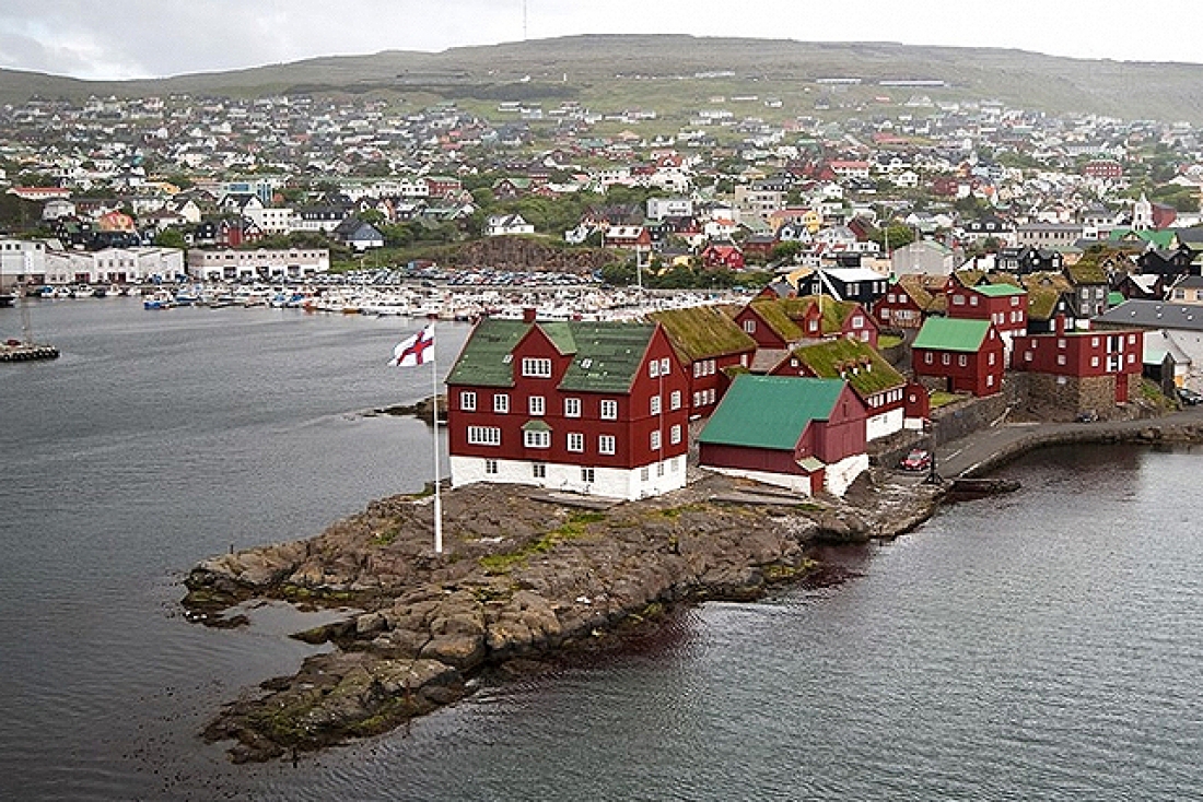
This area was the first site of the Parliament of the Faroes. The first general assemblies held by the Vikings were here, probably on the rocks at the point as there was only a farm here at that time. The Thing met here until 1816 when the parliament was moved to Uptown where it still is. In the Middle Ages, the area had many warehouses where trading occurred once per year and a large church seating 150 was built in 1609. They were all destroyed in a fire in 1673 and the present buildings, many government offices, date from that time.
Downtown is centred on the harbour with warehouses, pubs, and restaurants offering a full range of international and Faroese cuisine. Ferries from here go to Nólsoy and Suduroy. The old star-shaped bastion has two huge cannons dating from WWII.
Uptown. Pass through Vaglid Square with the parliament and city council building to a pedestrianized street. The Faroe Art Museum is in Viđarlunden Park with the football stadium (3 fields with stands), swimming pool, and Nordic House nearby.
Along the coast road is Hoydalar and on the other side of the hill the old farm of Hoyvik, now part of the National Museum.
National Art Gallery of the Faroe Islands (MAL). In Viđarlunden Park this gallery has a collection of 2600 pieces of Faroese art, mostly paintings. The south side of the building is built to look like a series of boathouses and is very attractive. Dk 65. I arrived at 16:50 just before closing and the lady let me have a quick free look. I didn’t enjoy it much except for some linocuts and one artist.
National Museum of the Faroe Islands (Tjóđsavn). In Hoyvik just to the NE of Torshavn, this museum has a wide collection of artifacts and information on the Faroes: archaeology, geology, fishing, many boat models, the national costume, and in the basement, several rowed fishing boats. Not all write-ups were in English and most were too wordy. DK60
Ólafsøøka. The national festival is held on July 28-29 in honour of St Olav the Holy who introduced Christianity to the islands after 1000 AD. People dress in colourful national costumes and attend events: a parade, rowing regatta, community singing and the chain dance, art exhibitions, sports, music, and good food. Parliament opens at this time.
KIRKJUBØUR
During the Middle Ages, this was the ecclesiastical and cultural centre of the Faroes. The bishop’s residence was here until the Reformation in 1556. The old village was situated on a plain that stretched from the King’s farm but most of the plain disappeared in a storm and today there are just a few ruins left. 76 people now live in the half-stone, black-painted houses with red windows safely situated further inland. Kirkjbøur is about 17 km from Torshavn on the west side of the south end of Streymoy.
Saint Magnus Cathedral. This Gothic church is better known as Muren. It was one of the finest churches in the Nordic countries when completed around 1330-40 but was dismantled with the roof, windows, and doors removed when the diocese was shut down in the Reformation in 1556. Over the years with rain, frost, and wind, the ruins deteriorated considerably. A restoration project started in 2003 used a shelter to try to dry out the building and the joints were repointed.
The walls are almost 1½m thick with huge stones chinked with small rocks. There are 5 pointed arch windows on the south side and Celtic crosses on the walls. A lovely bas-relief of the crucifixion is on the east outside wall. Free
St Olav Church. There has been a parish church here since 1111 with at least 3 previous churches on the site. It’s the only church dating from the Middle Ages still in use in the islands. In the centre of the east side is a hole where the lepers who lived on the other side of the mountain in Argir, could stand outside and listen to the sermon. The church has half-meter thick walls. The interior is whitewashed with natural wood beams, a roof, pews, and an altarpiece. The church is open daily from 8-8 with services on the first Sunday of the month. Free
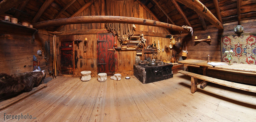
Roykstovan. The King’s farmhouse dates from the 11th century making it the oldest inhabited wooden house in Europe. It was built in Sognefjord in Norway, dismantled piece by piece numbered, and shipped to Kirkjubøur to be rebuilt. It stands on a stone foundation basement, in places 2m wide. Today it is occupied by the 17th generation of the Patursson family of farmers. The oldest part of the farmhouse is open to visitors and has wooden benches lining the walls, a huge wood table, a stove, and an odd assortment of artifacts. The door jambs are flanked by carved columns. The attic was the bishop’s office. Dk 30.
NORTH STREYMOY
Oyggjaregur Road. From Torshavn, there are two roads north. The old route is the Oyggiaregur going over the mountain – one long sight-seeing route over peaks and then deep down into the fjord valleys. There are 14 wind turbines on top.
Vestmanna. Tour boats reach the Vestmanna Bird Cliffs passing spiky rock pinnacles and passing through tight arches to see the breeding areas of guillemots, razorbills, fulmars, and kittiwakes in the thousands.
Walk between Vestmanna and Hvalvik in three hours on a cairned path
Vid Áir Whaling Station. Built by Norwegians in 1905, this is the only one of its kind left in the northern hemisphere. Used until the 1960s, the main catch was sperm and blue whales. Today it looks like a tired Hollywood film set.
Hvalvik Church. The old wood church here dates from 1829, the oldest wooden church in the Faroes. It is typical with a stone foundation, black-tarred walls, white windows, a grass roof with wildflowers, and a little tower. The pulpit dates from 1609 and once stood in the Cathedral in Torshavn. Sunday services are at 11 and 12 am.
Hvalvik also has Faroese willow or tealeaf willow. The ribs of the beautiful Faroese schooner Golden Harp that went adrift in 1924 is shipwrecked on the shore.
Haldarsvik. Head north on Road #54 from Hvalvik to this northern town on Streymoy, and pass Fossá, the highest waterfall in the islands that drops 140m in two stages before it runs under the road and out to the sea. The waterfall is best seen across the fjord with binoculars.
The town has a unique 8-sided church on the estuary in the town. The altarpiece depicts the ‘Last Supper’ painted by Torbjørn Olsen, one of Scandinavia’s most skillful portrait artists – the characters have the facial features of contemporary Faroese people.
Tjørnuvik. At the end of the narrow road is this beautiful valley with grass-covered terraces, a dark, sandy beach, Viking graves, two sea stacks, and enormous waves that make for the best surfing in the Faroes.
Kvivik. Just before the sub-sea tunnel to Vágar, this village has old Viking houses on both sides of the river Stórá and the remains of two Viking longhouses by the harbour. Toys, ornaments, and other artifacts from here are in the National Museum in Torshavn.
NÓLSOY ISLAND
Reached by a 20-minute ferry from Torshavn harbour, this island is opposite the city. It has colourful houses, an old wooden church, and a local museum. In the basement of the museum is the small wooden boat used by the island’s hero, Ove Joensen when he used it to row the 900 sea miles from Nólsoy to Copenhagen in 1985 to see the Little Mermaid. Ruins of the old village abandoned in the 17th century can be seen on the way out to the mountain.
The east coast has the world’s largest colony of the tiny storm petrel best seen on a night excursion as it flies along the mountainside in search of food.
The Borđan Lighthouse on the south tip of the island is a return 5-6 hour hike. The 1893 lighthouse is constructed of carved boulders. The lens weighs 4 tons, is 2.82m in diameter, rests on a bearing of mercury, is the world’s largest lens apparatus, and can be seen 16 sea miles away. Before automation, there were 30 people including 10 children living here.
HESTUR ISLAND
The village of Hestur lies in the middle of the eastern side of the island. Two paths lead to the island’s west side with its unusually flat plain with several small idyllic lakes. There are views down into Alvagjógv, a dramatic gorge that cuts deep into the island and the bird cliffs from above. It is possible to hike to the island’s high points, Eggjarók and Múlin for views of Koltur.
Grotto Concerts. Giant halls carved by waves into the mountains on the steep west side have unique acoustics. They hold concerts experienced from a boat on Tuesday afternoons during the summer.
KOLTUR ISLAND
One-day trips are available depending on the weather when it is possible to moor on the island – arrange at Tourist Information in Torshavn. Isolation has freed Koltur from civilization. Within the island’s only inhabited farm’s stonewalls is a large cultivated area once used to grow grain. Some of the old buildings have been restored. Take the steep hike up the south side of Kolturshamar Mountain (479m) above the farm. There is a little platform on top and the views are panoramic.
VÁGAR ISLAND
Use the Streymoy-Vágar sub-sea tunnel (toll 100DK return) to access Vágar Island.
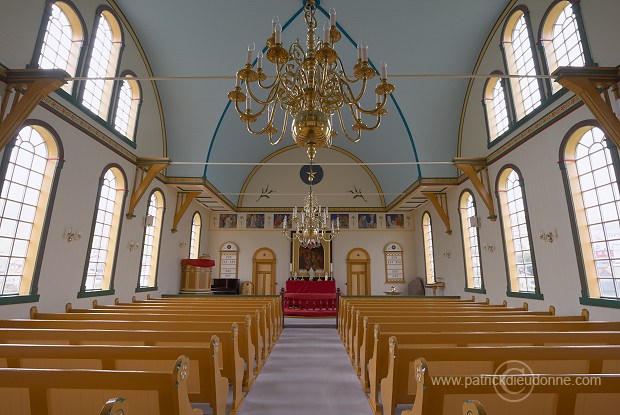
Sandavàgur. This small town at the mouth of a wide inlet has a lovely Lutheran church – built in 1917, it has white metal sides, a red roof, dark brown cookie cutter trim, and a weather vane cross on the steeple. It has been locked during the day for the last 4 years since someone broke in and stole the donation money, but the lovely caretaker was applying WD-40 to the locks and gave me a tour.
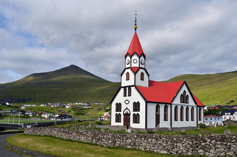 It was gorgeous with painted pews, scrollwork, flowers, and painted Ways of the Cross across the front. Three lovely brass chandeliers and a model ship hanging from the ceiling. A 1300 AD rune stone sits in the right front corner. It says “Torkel Onundarson, from the east in Norway, he was here first”.

Five war graves in the cemetery commemorate sailors from the ship Solarris killed on August 18, 1941.
Sørvágsvatn Lake. The largest lake in the Faroes looks like a fjord but has a very short outlet stream and is a long, narrow body of fresh water in south-central Vágar. On the east shore are several tiny rock houses with turf roofs. A sign on the shore said Drinking Water and I filled my jugs from the lake.
The Nix. This statue of a horse rearing up on its hind legs is heavy wire mesh filled with small rocks and sits in the water on the NW corner of the lake. A Faroe legend says that Nix lives in his home at the bottom of the lake and frequently comes to dry land. He lures people to pet and stroke him by appearing as a beautiful, kind, and tame horse, but once you touch his tail, you are permanently attached to him and he drags you to his home at the bottom of the lake. When the Nix hears his name called, he involuntarily loses his enchanting powers and releases his captives.
MÚLAFOSSUR. Drive to the NW corner of Vágur through a 1.4km, one-lane tunnel to the tiny village of Gásadalur (18 houses). Just before the village is a small lay-by to park and walk 300m to a viewpoint looking back to the waterfall.

A small stream descends from a huge bowl of cliffs above the village and falls about 60m into the ocean. The splash pattern in the ocean would be worth a picture. At the back of the cliffs is a small sea cave. Steep stairs with a NO ADMITTANCE sign descend to a rocky shelf below the viewpoint. The cement stairs are overgrown with sod but look safe and have an iron railing. A grassy trail crosses the stream and goes up through the village. It is 57 km from Torshavn.

MYKINES ISLAND
On the far northwest corner of the islands, this bird-watching paradise is reached by regular boat tours from Søvagur but is booked out months ahead. They put on extra boats – leaving at 12:30 and returning at 7 pm – 150 DK one way and charged the same as it was a special trip! A hiking trail to the 1909 Mykinesholmur Lighthouse leads through densely packed puffin burrows (in season – May to August) and across a 35m footbridge over a sea gorge brimming with birds, including the Faroes’ only significant gannet colonies.

The best views of this island can be had from the Múlafossur waterfall area.
Between the end of the peninsula and Mykines are two sea stacks, one with a big arch and the dramatic island of Tindhólmur – very narrow with a vertical west face and a serrated top of pinnacles.
EYSTUROY ISLAND
Wedged between Streymoy and Kalsoy, this island has the country’s grandest fjords and highland peaks. Especially spectacular scenery is on every turn of the road on the north. Cross the largest bridge in the Faroes to access Eysturoy. In the Nomad Mania series “Things to do” is bridge walking and I walked across this 250m long bridge with 8 piers. Many flocks of ducks were in the water on the east end.
Turn up Road #23 to follow the west coast of the island. From across the inlet are the best views of Fossá, the highest waterfall on the islands that drops 140m in two stages before it runs under the road and out to the sea.
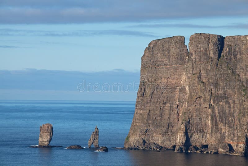
Eiđi. Go through the town and along the coast or turn up Road #61 to get the best views with binoculars of two wonderful sea stacks off the tip of the Eiđiskollur peninsula. Risin is seen end-on and is paper-thin with a thin rock on the top. Kellingen is seen side-on.

Road #61 climbs up to a high pass where there is a large parking area and trail to climb Slættaratinđur (882m), the highest and one of the easiest mountains to climb in the Faroes. I originally had no intent to climb it, but on a day the Faroese said “This is the best the weather ever gets” and access is so easy from the pass, I decided to do it. The route follows a hiker-made trail – basically steps cut into the turf ascending straight up the fall line and then switchbacks left to traverse under the west face of the mountain, circles behind it and climbs the last bit of cliff on the south corner. I took 1-hour up, spent 40 minutes talking to several people on top, and then only 30 minutes down as I basically ran the whole way. There were about 10 cars in the lot when I left and 24 when I returned with possibly a hundred people climbing it. It was an international group of people. I met two Americans from Spokane Washington, the closest large city to where I lived for 35 years and where I have been literally a hundred times with my children for hockey, my ex-wife to play bridge and to play all of the local public golf courses. I am always amazed when people climb mountains (especially in a climate like the Faroes where the weather can change quickly) with zero equipment except a light sweater.
The road descends to a junction with Road #60 that climbs to another pass and then descends north to Gjógv with its natural harbour.
Back at the junction, Road #61 descends via multiple hairpin switchbacks to Funningur. The 1847 Funninger Church sits on the edge of the sea next to the small stream that descends through the village. It is a tarred wooden building with a white stone foundation, shutters, white-painted windows, a small white tower, and a grass roof. The inside is plain natural wood with the most uncomfortable wooden pews imaginable – the narrow bench and vertical back require one to sit ramrod straight. The altar is separated from the nave by a gorgeous scroll-cut screen. Two brass chandeliers hang from the ceiling. The church was closed (as are all Lutheran churches on the islands) but there were many windows to peer through. This church is in both the Nomad Mania “Sight” and “Religious temple” series.

From Funninger, I drove across Eysturoy Island to Leirvik to cross via the sub-sea tunnel (toll DKK 100) to Bordoy Island and passed on the way:
Gøta Church. This 1833 black-tarred church (in the NM “religious temples” series) is virtually identical to the Funninger Church. Together with 3 fishermen’s cottages, boathouse, and rowing boats that form the old part of Norđragøta, this was once an ancient chief’s settlement with traces back to Viking times.
In the grass triangle next to the church was an unusual statue – three giant granite blocks with a statue of a man standing horizontally out from the face. He had a full beard and was dressed in an old-fashioned frock. On the back of the blocks was the inscription “MANGT UMSKIPASI A MANSINSVI, TRÓNDURT GØTU” and on the man’s base his name “Hans Pauli Olsen 2008”.
Leirvik. This village has restored Viking ruins, chapel ruins, and a village museum. There is a hiking trail over the mountain to Gøta.
Eysturoy has many peninsulas accessed by roads off the main highway #10 to take north: #62 to Eldivik (great diving), #63 to Hellinur and Oyndarfjørđur and #16 to Fuglafjørdur and south:#65 to Skála, Stendur and Selatraō, and #15 to Søldarfjøđur, Saltangará, Rituvik, Æđuvik, and Toftir. I didn’t go to any of these.
BORĐOY ISLAND
Klaksvik. The largest town in Borđoy, it has developed from a farming community to the fishing capital of the Faroes. The harbour is full of modern trawlers beside traditional rowing boats. The family-run Føroya Bjor brewery is here.
The LP Summer Festival is held here. It was in full swing when I stopped here on Friday night but the entrance was DKK 100 and the crowd was very young.
Pass through two eerie tunnels, both 3.1m high, 2.8m wide, one lane and no lights – Arnafjøđor (1680m long), then a stream and waterfall between the next tunnel and Hvannasund (2120m long) to completely traverse the north part of the island. A road follows the east coast to the village of Múli, a tiny cluster of four houses surrounded by a patchwork of fields and stonewalls extending on both sides.
KUNOY ISLAND
Cross a dam from the west side of Borđoy and then pass through the width of the narrow island in the Kunoy tunnel – 1 wide lane, no lights, 4.6m high and 3031m long – a virtual freeway compared to the tunnels on the north of Borđoy.
Kunoy Island has six of the ten highest mountains in the Faroes, all over 800m high.
Climb Eggjarsteinur, the rocky mountain behind the village of Kunoy, a group of about 20 houses. An easy recommended hike is the 3-hour walk from Haraldsund to Skarđ along the coast. A memorial among the ruins tells of the tragedy on Dec 24 1913 when seven men drowned in a storm at sea, leaving families with no means of survival there. The last residents left in 1919.
There are wonderful views from the village of Kunoy west to the island of Kalsoy, nicknamed the “flute” for the tunnels, and brief glimpses of the majestic scenery. It is reached by ferry from Klavsvik. Five tunnels are traversed to visit all the villages on Kalsoy
VIĐOY ISLAND
Reached by a bridge from Borđoy, one passes through the Viđaređi tunnel – 2-lanes with lights and 2kms long – completely to the other side of the island for the most majestic views so far in the Faroes. The massive vertical cliffs on the north side of tiny Fulgoy Island appear (reached by a ferry from Havannasund just across the bridge on Viđoy). The top was shrouded in cloud.
Viđareidi, the most northerly town in the Faroes sits in a dramatic setting in a narrow saddle between two peaks with views of the islands on both sides. The magnificent church silver was given to the village by the British government in recognition of the charity and hospitality shown to the crew of the Marwood that was shipwrecked in 1847.
To the north of town, Villingardaisfjall mountain (the highest mountain in the northern Faroes) rises to a serrated ridge with the massive vertical cliff of Enniberg, the Faroe Islands most northerly point, and at 754m, one of the highest cliff promontories in the world. I imagine it looks like Fulgoy. A daylong hike over the peak negotiates a gorge and out to the edge.
Drive down to the water by the church for great views of the entire north end of Borđoy Island. Then continue on the road above town down the west coast of Viđoy and the bridge to make a loop. There are no other roads on Viđoy.