
South & East Iceland – August 3-9
FJALLABAK NATURE RESERVE
The Fjallabak route (F208)is a spectacular alternative to the coast road between Hella and Kirkjubæjarklaustur and gives access to Landmannalaugar, possibly the prime hiking area in all of Iceland, and the start of the Lanugavegurinn Trek (usually shortened to Lanugavur).
LAUGAVEGUR TREK (LANUGAVEGURINN TREK) (Days 9-11)
This 53km trek from Landmannalaugar to Thórsmönk is one of the premier walks in the world and has been on my bucket list for many years. The name means ‘Hot Springs Road and is studded with geothermal activity, primarily fumaroles.
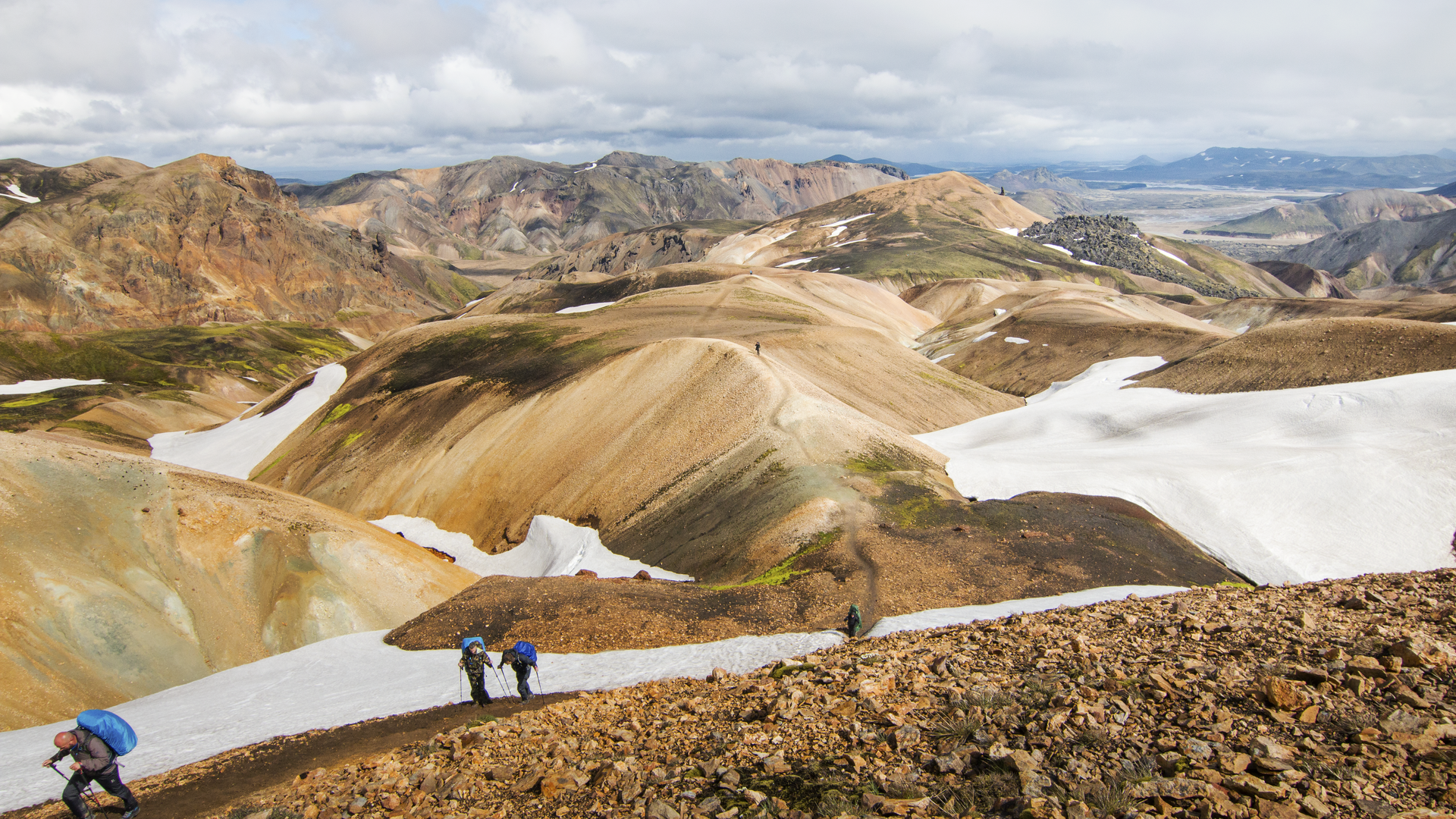
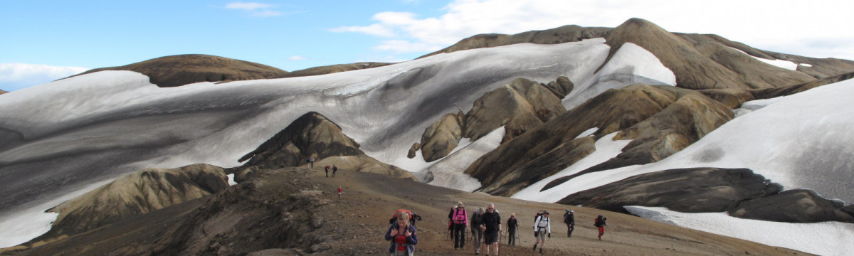
The recommended route is from north to south to take advantage of the net altitude loss, but it seemed that almost as many were walking in the other direction. Usually, 3 or 4 days is required. The route is very well-traveled with an easily discernible trail all the way, well waymarked with frequent wooden posts (and sometimes cairns). Areas over the large snowfields traversed are obvious with all the traffic. When I started the walk, my only information was the rudimentary notes and map in the Lonely Planet – and someone told me to follow the wood posts painted red.
It is recommended to have a large-scale map and GPS if walking without a guide but these would only be of value for navigation in dense fog or a whiteout blizzard. A map would identify some of the geographic features surrounding you and label the rivers crossed.
There is no permit required and no registration. The track is almost always passable from early July through to mid-September. It is recommended to have 5-days worth of food, a good tent, warm clothes (toque and gloves are mandatory and a buff and down jacket is strongly recommended), and wet weather protection (I use an umbrella often when hiking but here the strong winds would have made it useless) all using a proper layering system. Four substantial rivers that require wading are crossed, so some sort of footwear to protect your feet is necessary. I brought thongs but they were not the best as currents are fast in sections of each river. The water is very cold. The water was never above the lower calf.
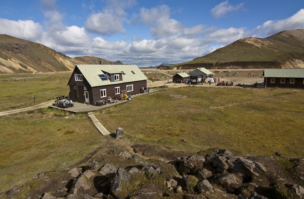
There are three huts positioned 12 to 15kms apart, but these require advance booking months in advance. The huts are owned and maintained by Ferđafélag Islands (www.fi.is) and their website breaks the trek into four sections with detailed instructions. The huts are heated, have outdoor toilets, and provide showers and cooking facilities. Bringing your own sleeping and food is necessary. The cost is ISK 9000 per night.
However, most doing the trekking camp at designated areas around the huts. Campers do not need to reserve and there are many sites. But there are also hundreds doing the trek so arriving early gives access to the best sites. Camping fees are ISK 2000 collected at the office, a separate building at each hut location, and run by rangers. The facilities provided for campers are an outdoor toilet and a small open-air cooking space with running water. Access to the huts is not possible and spending time in the office is discouraged. So if you are totally soaked and it is storming outside, you must be able to manage on your own. Setting up your tent in driving rain can test your ability to keep dry.
Food. I elected to not bring a stove for weight and space reasons. My menu was:
BF – cereal and milk (I could not find powdered milk and brought 1 litre of UHT milk.
Lunch – vegetables and hummus, Wasa crackers, and cream cheese.
Dinner – ham sandwiches (mustard, mayo, ketchup, grated cheese, lettuce).
Snacks – peanuts, taco chips, and cheese dip.
Drink – water.
Transportation to Landmannalaugar and Thórsmönk. There is no direct transportation or shuttle service between the two. And getting to each necessitates travel on rough gravel roads and crossing rivers requiring high-clearance vehicles, so don’t even think about taking your passenger cars. Rental vehicle insurance is invalidated if a problem happens crossing rivers.
The best plan is to park your vehicle at Hella with a bus stop serviced by all four bus lines and a big, free long-term parking area. The stop is in front of all the businesses lining the highway and is obvious. Access is from the circle in front of the gas station. There is also a large garbage container in the corner of the lot. The walk from your car to the bus is about 25m. The buses are all able to manage the deep river crossings.
Bus companies. All can be booked online but usually, there is room if you haven’t reserved. The two main companies are Trex and Reykjavik Excursions. Timetables are on cards at each company’s stop. Hella is on routes from Reykjavik traveling to many destinations along and off the N1 along the south coast. It is confusing to sort out the exact times of departure as each company has a different configuration and the following only gives times from and to Hella. There are three potential bus stops at Thórsmonk; Basar is 2kms past Thórsmönk at Gödaland and should be avoided; Langidalur is the main bus stop in Thórsmönk and all companies stop here, and Húsadalur (also called Volcano Huts Thorsmork) is on the road out from Thórasmönk (I am not sure but it may be an easier walk than going over the ridge to Thórasmönk).
1. Trex. Hella to Landmanalaugar: departures at 07:55, 09:35, and 14.35 taking 2hours and about 10 minutes. Thórsmönk (Langidalur) to Hella: Departures at 14:30, 18:00 and 20:10.
2. Reykjavik Excursions (www.ioyo.is). Their schedule involves 5 date periods, goes everywhere and the print on the route card was so small that I could not figure anything out. Their website also only supplies “passes” and as I didn’t want to obligate myself to one company, I didn’t plan on using them. But they offer the most complete service and often have multiple buses on each route. They are also cheaper than Trex.
3. Stenna (www.icelandbus.com): H to L: depart 09:00. T to H: depart 20:15.
4. Thule (www.thuletravel.is).
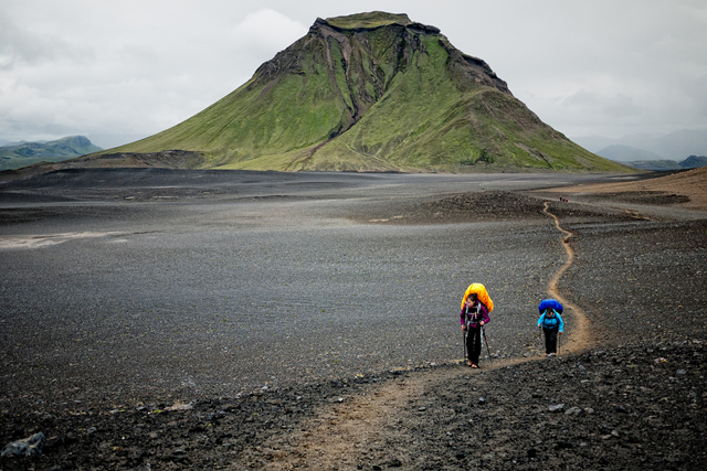
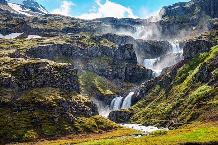
Day 1/3 – Landmannalaugar to Hrafntinnusker (12kms)
I slept overnight in the Hella long term parking lot and caught the Trex bus at 07:55 (ISK 6900 – credit card or cash). I did not make a reservation but there was lots of room. It drives on pavement for about 45 minutes and then the route turns east onto a gravel road. Cross a relatively shallow river and then two more rivers just before Landmannalaugar proper.
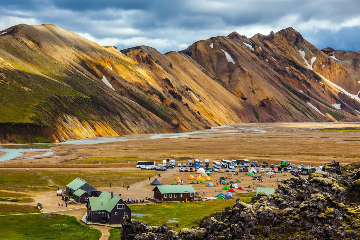
Landmannalaugar is nothing more than a large parking lot and tent city. There is an information centre/ranger station and a bus converted into a grocery store, but no other facilities that were obvious. It is a very popular place full of day hikers who come for one day or more. There are many day hikes and a map that details them can be purchased at the information centre. It is a gorgeous area with low rhyolite mountains in various shades of oranges and yellows, lava fields and many geothermal features including a hot springs.
I started walking at 10:30. The route on day 1, except for a few flat areas, is a continuous climb to the high point of the entire trek and then a short descent to the hut. The Lonely Planet stated that it was a “relatively easy start to the adventure” but I don’t think the author did the same hike as me. The trek starts just east of the information centre – follow the red/white stakes that soon become red only.
At 12:30 it started to sprinkle rain and soon the strong wind was blowing the rain horizontally. All plant life disappears and one passes fields of gravel littered with obsidian or volcanic glass. Before the Bronze Age, this place would have been a gold mine of spear points, knife blades, and arrowheads. In early August there were large patches of mushy snow. Pass the Haala fumarole field and a plaque attached to a rock commemorating a 24-year-old who had died here in a blizzard in 2004. But in all but a white-out, the route is easy to follow.


I played leapfrog with a group of 5 young Israelis, all with identical gear – they had gone together to “group buy” all their stuff to get the best deal. Fog appeared and my pants were soon soaked as I didn’t have rain pants.
Finally, reach the high point of the day and the entire trek, ominously marked by a cairn topped with a flashing white light. It is then a short descent to the hut.
Check in at the office, pay your ISK 2000 camping fee and head down to the camping area, each spot has a rock wall for wind protection. I set up my tent in the lee of the small cooking hut to try to keep it as dry as possible. This was the first time I had set up my new MSR Hubba Hubba NX tent but I have used a normal Hubba Hubba for years. I finally got out of my wet clothes and hung them from a clothesline I put up in the tent and settled into my sleeping bag. One trick with damp clothes is to put them into the bottom of your sleeping bag and they manage to dry considerably overnight. After shivering for an hour, I finally was snug as a bug in a rug and ate supper in a reclining position, where I stayed for the next 14 hours. I was thankful that I had not bought a stove as it would have meant cooking in the open-to-the-elements cooking shed. Thank god for pee bottles as it rained hard until about 10 pm.
My sleeping bag is only rated to +4°C but with socks, merino long johns, two tops, a touque, and a buff, it was quite comfortable.
Day 2/3 – Hrafntinnusker to Áiftavatn (12kms) & Áiftavatn to Emstrur (16kms)
I was up early and started walking at 06:35. I counted 24 tents in the camping area as I left. It was a lovely cool morning with little wind and a few clouds. I made up my mind fairly early to make it a big day and skip staying at the second hut at Áiftavatn – arriving there before lunch, there would be relatively little to do; the weather was great and it seemed wise to make the best use of the day; I wanted to avoid paying for another ISK 2000 campsite, and this would give me an extra day to see South Iceland before the ferry.
After an initial descent from the hut, the route slowly descends through dark brown gravel devoid of plant life.
 After almost 7 km, the trail reaches a high viewpoint with Áiftavatn far below on the edge of a big lake.

The descent was a real knee-knocker down to the valley floor. On the way, I passed 2 Canadian couples and had some nice chats. Sheep appeared beside the trail. I had a long break in the sun to take off clothes and have a long snack and met a young Korean woman with a tiny pack who had made her reservations to stay in the huts in January. Because of the big descent, the climate here is much more temperate.
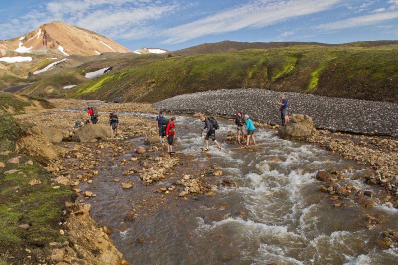
I soon crossed the first major river without a bridge and made it without getting my feet wet but needing my poles to make some of the long jumps and balancing acts on rocks.
Walk a road for the last kilometre to the hut and was surprised at the vehicles and recreation vehicles there. It is a common place to drive to and then mountain bike the trails.
After a short climb out of the valley, cross two major rivers necessitating removing your boots for the wade. After the second river, I met two young Thai brothers, Game and Guy, and walked with them to Emstrur. From a wealthy Bangkok family, one was taking chemical engineering at Cambridge and the other medicine at King’s College in London. Both had travelled to many Western countries but never to SE Asia and were very pleasant company. This was the first time they had ever been on a trek but wanted to do many more. Most of the distance was flat on a road and we passed several 4×4 vehicles. The wide valley was flanked by sharp-edged peaks covered in lovely emerald green.
Day 3/3 – Emstrur to Thorsmörk (15kms)
Up at 5 am, I ate breakfast, packed my now dry clothes and tent, and was walking by 6:40. It was cold with a strong SE wind. After 35 minutes, descend a steep, sandy gully to a bridge crossing a stunning narrow gorge and a raging river full of dark grey water. The floor of the valley was lime green moss and stunted heather. It was a short climb out of the valley and I had a break at 70 minutes in the lee of a cliff, the only windbreak the whole day. I had great views of the rugged canyon with its twisting layers and outcrops of lava.
The trail slowly descends as you cross two stunning narrow gorges with rough lava walls and a river far below. It was then a significant climb out of that valley before descending a long way to the last big river of the trip.

After crossing this large river (that requires taking your boots off), about 3 km from Thórsmörk, I had hopes that it would be flat into the town, but shouldn’t have gotten my hopes up, as it is necessary to cross the big ridge south of the river. Eventually, the trail meets a road and you come to a fork and a sign – 1.5kms on the road to the right to Húisadalur (also called Volcano Huts Thorsmork) or the trail to the left 1.5kms to Langidalur (or Thórsmörk where the main bus stop is), and then continuing past Thorsmörk for 2 more kilometres to Básur (technically in Gođaland).
It depends on the bus company if they stop at all three, but all stop at Langidalur, so I went to the left on the trail. It continued to climb up to the top of the ridge where there were views a long way down to a few buildings on the edge of a huge, rock and gravel river course. The descent was steep and I finally arrived at 12:30 for a 6-hour day. I found this last up and down the most difficult of the whole trip as I was feeling pretty knackered.
Thórsmörok. This “town” consists of a hut, toilet facility, campground, and a bus stop on the road. Arriving here is impossible for the average car as 3 deep rivers must be crossed.
The Trex bus was waiting but was fully reserved, and luckily a Reykjavik Excursions bus appeared at 02:15 that had room. Costing ISK 5300 to Hella (Trex was ISK 5900), it left almost immediately.
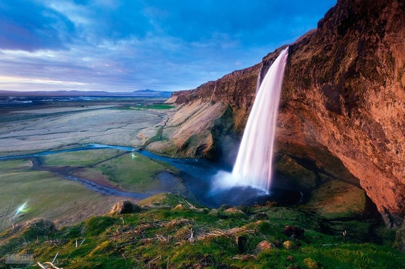
The bus crossed the huge floodplain of the multiply braided river going through two large channels. The lava walls lining the river are rugged and full of spires and broken rock. Within 15 minutes the bus arrived at Húlsadalur, a routine stop for Reykjavik Excursions. The large crowd filled our bus (irritating those with reservations) but a second bus arrived within 5 minutes to take the rest. We crossed another deep river channel and passed the gorgeous Seljalandsfoss Waterfall, three waterfalls dropping off a long cliff. It is possible to walk behind the largest falls. Seljalandsfoss is a beautiful nature area with its own microclimate created by the protection of 3 surrounding glaciers.
The gravel road soon intersected with N1. We stopped at Hvelsvölar and waited for 45 minutes to board another bus that only went as far as Hella. A different bus continued to Reykjavik from Hvelsvölar.
I finally arrived at my van at 18:30 for a 14-hour day. I emptied my pack, dried out anything that was wet, cleaned my tent, and stored everything away. I eventually drove the few kilometres east back to Hvelsvölar and slept in the parking area of LAVA – Iceland Volcano and Earthquake Centre.
Fimmvörđuhálskali Pass hike. This 23km hike between Thorsmörk and Skogar is very popular in its own right and is often a one or two-day extension to the Lanugávegurinn Trek or more commonly a day hike.
The pass sits between two glaciers: Mÿrdalsjøkull to the east and Eyjafjallajökull to the west. There is a new lava field at the pass formed in the 2010 Eyjafjallajökull eruption that stopped all air traffic across Europe for weeks. A hut at the pass is run by Útivist and can be hard to find in bad weather, but no campsite. The pass is high and the weather can descend very quickly.
Transportation is easy. The best way would be to park at the Skøgar Waterfall parking lot, just off the south ring road. Climb the stairs to the viewpoint above the falls and continue on the trail that goes alongside the creek. At Thorsmörk, several buses can be gotten to Hella and then transfer to Skøgar.
KATLA UNESCO GLOBAL GEOPARK
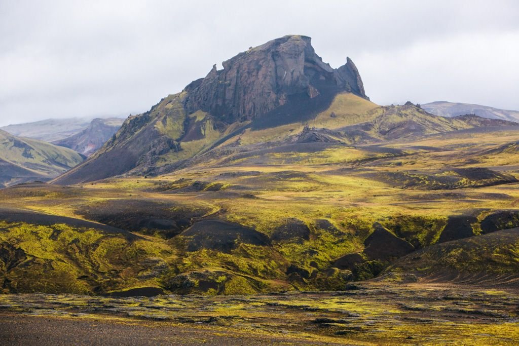
At 9542 km2, Katla lies along the south of the Mid-Atlantic Ridge, the most volcanically active area of Iceland. Frequent activity constantly changes the landscape. Ice-capped central volcanoes rule the area and outlet glaciers and glacial rivers flow from them outburst from subglacial eruptions have formed the great outwash plains in the lowlands The world’s largest field of cones and most extensive lava fields of modern times are covered in fragile moss.
Hvolsvöllur District. This district ranges from the highlands to the sea and contains Skogafoss, Seljalandsfoss, Thorsmonk, and Eyjafjallajökull volcano. Hvolsvölur is the urban centre.
Myrdaslhreppur District. In the middle of Katla, it is bordered by the Jökulsa River to the west, the river Glautakvisi to the east, and the Myrdalsjökull glacier to the north. The main town is Vik. Reynisdrangar are the sea stacks visible from the town, Reynisfjall Mountain and beach and Dyrholaey headland are the main attractions.
Skaftarhreppur District. The eastern district of Katla gives access to Vatnajökull National Park.
Day 12
This day was a cool 12°, moderately overcast day, but with no rain.
VESTMANNAEYJAR (Westmann Islands)
This group of 13 jagged islands forms a stunning silhouette from the south shore. They were formed by marine volcanoes about 11,000 years ago. The exception is Surtsey, the archipelago’s newest addition that rose from the waves in 1963. It was made a UNESCO World Heritage Site in 2006, but its unique scientific status means that it is not possible to land there.
Heimacy is the only inhabited island. Its little town and sheltered harbor le between dramatic escarpments and two ominous volcanoes – blood-red Eldfell and conical Helgafell. In 1973, unforgettable pictures of Heimacy were broadcast across the globe when a huge eruption buried a third of the town under 30 million tons of lava.
It is now famous for its approximately 10 million puffins, its festival, and its volcano museum.


Eldheimar. Over 400 buildings were lie buried under lava and on the edge of the flow, “Pompei of the North” is the museum resolving around one house excavated from 50m of pumice along with what was formerly Suđurvegur. The house has toppled but intact knick-knacks and is filled with multimedia exhibits. A catwalk crosses over the wreckage and there is an exhibit on Surtsey.
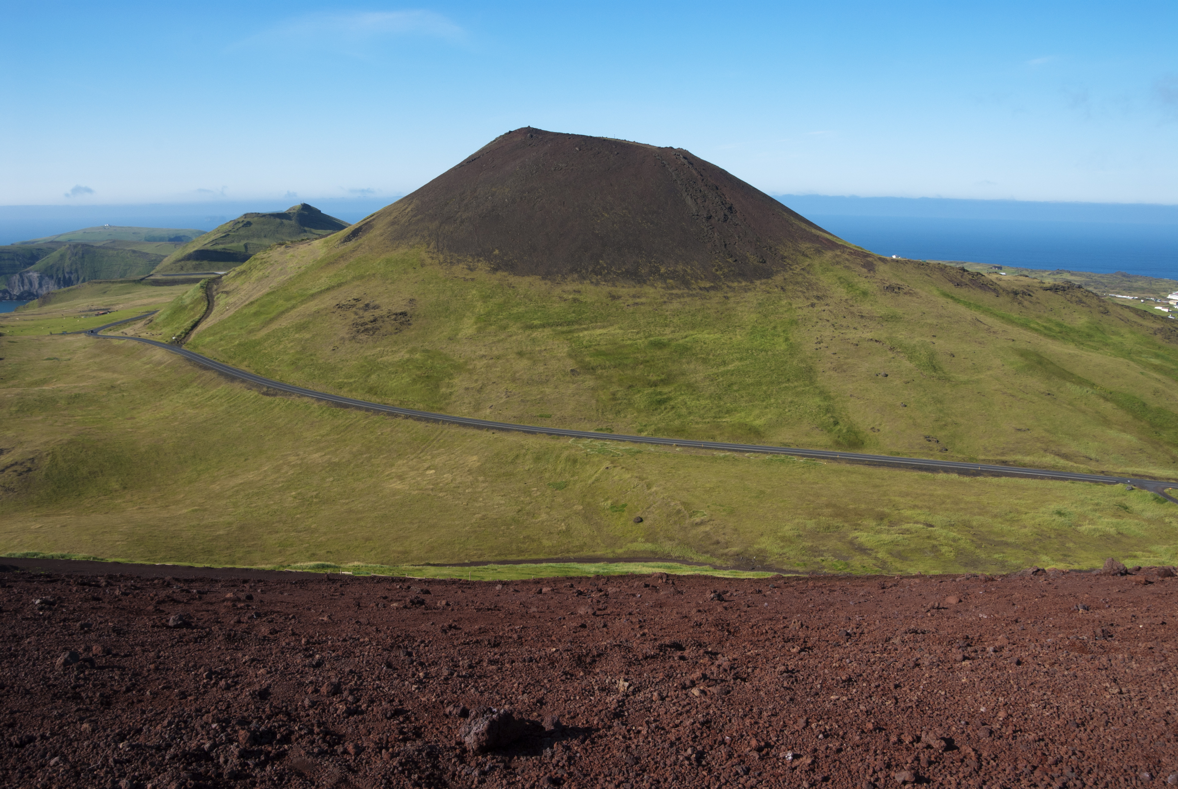
Eldfell. This volcano appeared from nowhere in the early hours of Jan 23 1973 and heat from the volcano provided Heimacy with geothermal energy from 1976 to 1985. Today the ground is still hot enough to bake bread or char wood. It is an easy climb from town, up to the collapsed northern wall of the crater.
Edfellshraun. The new land created by the lava flow is now crisscrossed with a maze of hiking tracks that run down to the fart at Skansinn and the house graveyard, and all around the bulge of the raw, red eastern coast with small black-stone beaches, Gaujulandur lava garden, and a lighthouse.
Skansinn. A 15th-century fort was built to defend the harbour – not too successfully – as Algerian pirates landed on the other side of the island in 1627. The fort’s walls were swallowed by the 1973 lava but some were rebuilt. Above them are the remnants of the town’s old water tanks, also crushed by molten rock.
House Graveyard. The edges of the 400 buildings peeking out from the lava at the edge of the town nearest the lava flow.

Thjóđhátiđ. This 3-day festival held over the last weekend in July or the first weekend in August, is the country’s biggest outdoor festival. There’s music, dancing, fireworks, a big bonfire, copious drinking, and as the night progresses, lots of drunken sex (something of a teen’s right of passage). Upwards of 17,000 attend.
When I tried to go to the island on the last day of the festival (Monday, Aug 6th), cars were parked along the road for a few kilometres from the harbour, and all return ferries were booked until Tuesday night.
The Eimskip ferry leaves from Landeyjahöfn about 12 km off the ring road, 30 minutes, 5x a day. ISK 2260 return
Seijalandsfoss. This is the spectacular waterfall I first passed on the return from the end of the hike. It forms a powerful wall of water from two glaciers and often produces two rainbows. The walk behind the falls is spectacular but you will get wet from the spray.

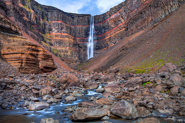
Skogafoss. This spectacular, dizzying high waterfall falls into a large bowl, shrouded in mist and rainbows. It sits just north of N1 at Skoga. Climb the 442 steps to a viewing platform with not a great view of the falls. This is the start, or end, of the 23km hike over Fimmvörõuháls Pass to Thórsmörk. From the viewing platform walk as far as you want along the trail that follows the south side of the river. There are some nice falls between stacks of rocks not far along.

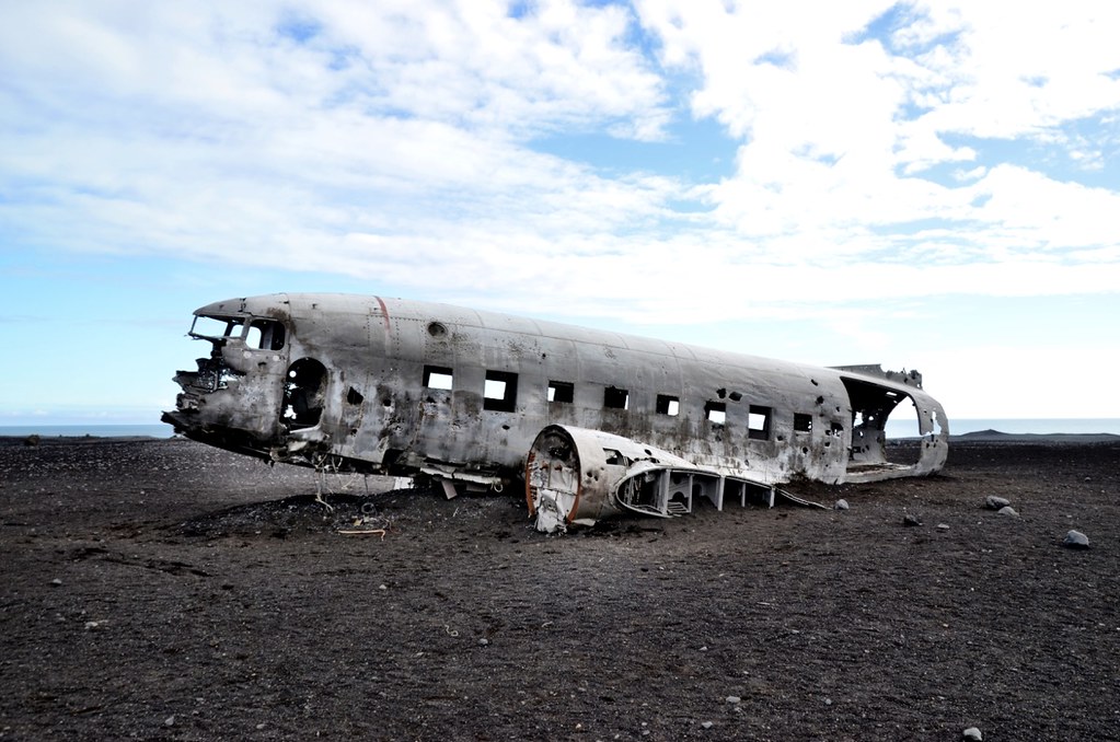
Plane Wreck at Solheimasander. In 1973 a United States Navy DC plane ran out of fuel and crashed on the black beach at Sólheimasandur, on the South Coast of Iceland. Fortunately, everyone in that plane survived. Later it turned out that the pilot had simply switched over to the wrong fuel tank. The remains are still on the sand very close to the sea. From the car park on the south of N1, walk 7kms to this plane on the beach. Allow 3-4 hours to return. Driving there is forbidden because to approach the plane you had to be driving on the black sand, in a 4WD, and the sand can be pretty soft in some places.
Along this section of the road, there are great views of Mýrdalsjökull Glacier.
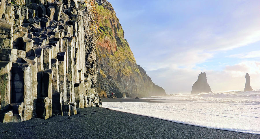
Dyrhólaey. This rocky plateau and nature reserve sits separately from the coast at the west end of Reynisfjara black sand beach, 10 km west of Vik. The south end of the plateau is a dramatic thin peninsula with two sea arches, the largest of which allows the passage of a 30-ton ship. The cliffs rise 115m at the 1928 lighthouse (the largest lens in Iceland). There are also several sea stacks, one with 2 arches. There are great views west along the never-ending black sand beach and east to Reynifjara and the stacks at its east end.

Reynisfjara. Route 215 leads 5 km down to this black sand beach. The main draw is the cluster of grey basalt columns that look like a church organ at the east end of the beach. The cliffs have large caves formed of twisted basalt. A cluster of sea stacks called Reydrangur rises up to 63m off the point.
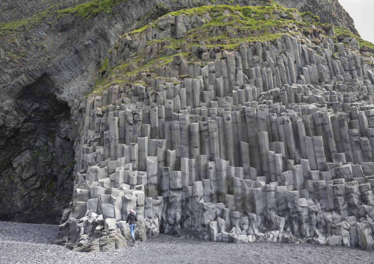
When I returned to my car from seeing the basalt columns, my left front wheel was flat. As this was my first flat, it was an adventure to find the jack and change the tire.
VIK (pop 295). This little community is the hub for a very beautiful portion of the south coast. Iceland’s southernmost town is also the rainiest. It is fronted by an infrequently visited black sand beach and has a “mall” with a good grocery store, Iceland outlet, restaurant, and coffee shop.
Redranger sea stacks are a prominent site to the west. Walk from its western end up a trail to the top of 340m Reynisfjall ridge offering superb views down to the sea stacks of Reydranger and Reynisfjara beach.
Vik Church. This small white church with its red roof and red spire has a commanding location on the hill looking down onto the town. It has an interesting 4-sided cross and lovely stained glass depicting bible stories.

I spent the night in Vik to get the tire fixed in the morning.
Day 13
I got the bad news at the garage that the tire was destroyed due to a large cut on the lateral wall – how had I got that? The only place with a replacement was likely to be Selfoss, 150 km back in the wrong direction. I stopped at 3 garages on the way and none had the tire. Selfoss didn’t either but managed to find a ‘second hand’ tire the right size. In the shop, we traded tire stories with all the others with flats and many needing tires not available. Rental vehicles tend not to have great rubber. The used tire and installation cost ISK 5900, considerably less than the 6900 I was going to be charged by the first garage for the repair.
Returning to Vik where I had been eight hours previously (I had a short nap), I picked up a lovely hitchhiker, a young fellow from Tucson.
This was an extremely windy day – the van was jostled all over the road and leaped 4 feet to the left every time a bus passed. I marvelled at the cyclists heading west struggling into the wind. Cycling in Iceland can’t be all that much fun. A lot of the ring road has few great views. Getting off the N1 to see the nice places would be difficult and the wind blows most days. It is surprisingly flat though with far fewer hills than one would imagine.
The road eventually passed through a huge flat plain of gravel and sparse yellow grass studded with small conical mounds of lava. There was a brown-out from all the dust picked up by the ferocious wind. I stopped at a layby where some foolish travellers had built thousands of tiny cairns.
In 1783, a huge lava flow streamed down from Lakagigar in what has become known as the Laki eruption. This is believed to be one of the largest lava flows in the history of the world with 16 cubic kilometres of lava and 580 km2 area. All around thick woolly fringe moss moss forms a continuous layer. The moss has taken 200 years to grow and is very sensitive to tramping. After passing through this huge field of aa lava covered in lovely Icelandic moss – tan/yellow with a tinge of green – there was a detour of about 50kms, initially on a piece-of-shit, completely wash-board (corrugated in Australia), rough gravel track, then single lane pavement and finally a reasonable pavement road.
The Lakagigar (Laki Craters) is a 25 km long row of craters above Kirkjuhæjarklastur formed from the Laki eruption. They can only be reached by 4×4 vehicles as there are unbridged rivers to cross. They are part of the National Park.
Eldgja is a 40km long eruptive fissure, 600m wide in many places and 200m deep. From 934 to 940, an eruption occurred along the whole fissure and poured 18 km3 of lava out. The Ofaerufoss Waterfall is located in the middle of the fissure. The area is part of the National Park.
KIRKJUHÆJARKLAUSTUR
This tiny village is surrounded by historic landmarks. It was first settled by Irish monks. A Benedictine convent then existed from 1186 until 1554 and the Reformation. Many things in the area are named after the nuns: Systrafoss (Sisters Waterfall) a stunning cascade down a steep rock wall,
Systrastapi (Sisters Rock) where two nuns were buried after being burnt at the stake for indecent sexual behaviour and blasphemy (I believe the rock is the gigantic boulder that the outlet of the waterfall flows under) and Systravatn (Sisters Lake) on top of the cliff that is the source of the waterfall.
There is an unusual modern church with sloping concrete patterned walls down by the road.
The Church Floor (Kirjugólf) is an eroded columnar basalt outcrop. The columns always stand perpendicular to the cooling surface and are therefore vertical in lava flow and sills, horizontal in tunnels, but radiate out from the centre of pillow lava. When lava cools and contracts, its surface area decreases, and the difference while cooling causes the surface area to decrease, forces build up in the lava, and in the end, it cracks into columns, which are usually 5 or 6-sided but can be up to 10-sided.

From the roundabout, take the road 500m towards Geirland and park on the left at the sign. Then walk back on the gravel path for about 200m.
Laki Road. Just west of Kirkjubæjarklaustur, leads into the highlands to the Laki craters, the Eldgiá fissure, the moss-covered Laki lava flow, Skaftáreiidahraun and pseudocraters derived from the Eldgiá eruption. It then continues to the Fjaõrargjufur gorge, a magnificent site.
Day 14
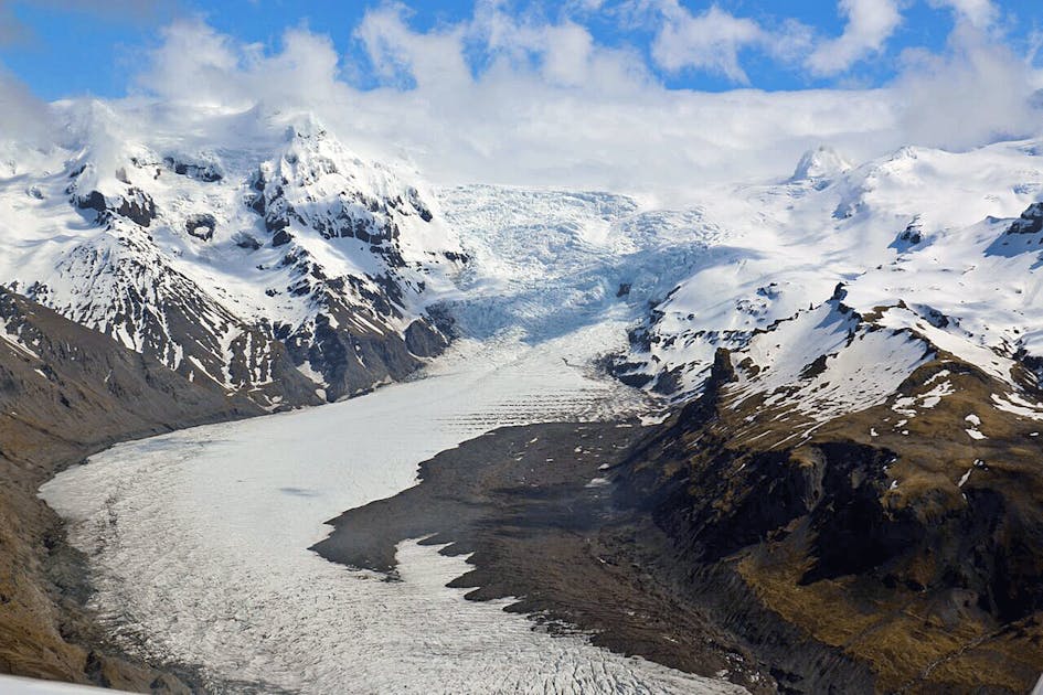
VATNAJÖKULL
Vatnajökull is the largest glacier icecap outside the Arctic region, with an area of 8100 km2. It measures 950m thick at its thickest point with an average of 400m. It contains more the 2000 cubic kilometres of water, the equivalent of a 30m thick ice layer extending over the entire area of Iceland. It rests largely on a plateau measuring 600-800m in altitude and only about a tenth of the base rises above 1100m in altitude.
A nunatak named Palsfjall is in the western glacier and a geothermal area and the ancient Grimsvótn volcano is in the middle of the glacier. At least 30 outlet glaciers flow down from Vatnjökull’s bulk with many visible and accessible to varying degrees from the Ring Road in the southeast.
History. At the time of settlement of Iceland, the glacier was much smaller than it is today, but it grew steadily during a cold period lasting almost unbroken from the 14th century to the beginning of the 20th century, reaching its greatest extent in the late 19th century. During a warm period in the 20th century, the glacier tongues receded by 2-3 km and in some places where there used to be a 200m thick glacier, there is now bare land.
It is believed that travel across the glacier was common until the 16th century when the practice was discontinued. The first expedition crossing it in recent times was in 1875 when 60kms was covered in 12 days by William Lord Watts, a 20-year-old English lawyer and 5 Icelanders. Since the 1934 eruption of Grimsvótn, there have many trips to inspect areas of volcanic and geothermal activity and the source of the outburst floods.
The Glacial Outwash Plain. The ring road didn’t extend across the glacial outwash plain (area 1000 sq. km) until 1974. There are frequent outburst floods on the plain, endangering travellers and destroying vegetation, settled areas, and manmade structures. The floods travel for 30 km under the glacier from Grimsvötn, where meltwater collects in an area of geothermal activity. There are also bursts from glacial dams that accumulate precipitation and meltwater. Grænnatón is the largest of these ice-dammed lakes. Some of the most active volcanic areas in the country are hidden under Vatnajökull, and over the last 800 years, about 80 eruptions have occurred. A large burst came down the channel of the river Djupá after an eruption in 1753, destroying grazing land and accumulating rocks that can still be seen on the riverbanks.
In November 1996, the road crossing the Seioararsandur sand flats was washed away in a huge glacial flood following an eruption north of Grimsvötn in the Vatnajökulll glacier. The floodwater reached its highest level in 15 hours and subsided over the following 2 days. The maximum flow rate reached nearly 50,000m3/sec. Huge blocks of ice were swept along by the flood, causing damage to the road, The 376m Gigjukvisl Bridge was completely washed away, and the Skeiőaraa Bridge was also badly damaged when the 176m easternmost unit and the central pillar of the westernmost unit were swept away. The land bridge to the west disappeared in the flood. It is estimated that the icebergs that reached the bridge weighed up to 1-2,000 tons.
VATNAJÖKULL NATIONAL PARK
It was founded in 2008 with its boundaries encompassing the ice cap and the former Skafnafell and Jókulsdrgljúfur national parks to form one giant megapark. With recent additions, the park now measures 13,900 km2 – nearly 14% of the entire country. There are major park visitor centres at Skaftafell in the south and Asbyrgi in the north (east of Husavik) as well as at Hófn and at Skriđuklaustur, near Egilsstađir in Iceland’s East.
Skaftafell. This is the prime centre of activity for the park giving access to a huge collection of peaks and glaciers. It’s the country’s favourite wilderness with at least 300,000 visitors per year. There is a large campground and pay-for-parking area.
Six-day hikes and 3 longer treks are listed at the visitor’s centre from Skaftafell.
Glacier hikes are a highlight for anyone who has not been on a glacier before. There are many authorized guides in the area.
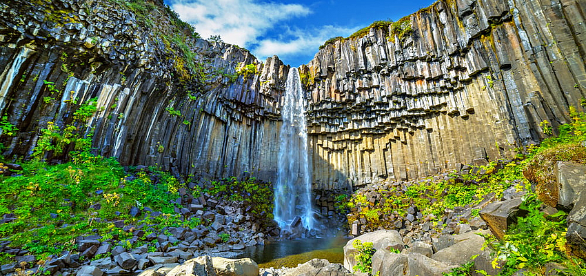
Svartifoss (Black Falls). This stunning waterfall is flanked by geometric black basalt columns. It is reached by a 1.8km trail from the visitor centre via the campsite.
Skaftafellsjökull trail. This 3.7km, 1-hour return walk begins at the visitor centre and leads to the glacier face – much greyer and grittier than you would imagine.
Skaftafellsheiđi trail. A 15.5km, 5-6-hour loop walk.
Öræfajökull glacier is a volcanic crater about 5km in diameter, full of ice. Along its edges, several peaks thrust out of the glacier of which the northernmost is Hvannadalshnùùkur, the highest mountain in Iceland (2110m). Two major volcanic eruptions have occurred in this glacier in historical times: the first in 1362 and the second in 1727. It is still an active volcano. There are several well-known hiking paths up Hvannadalshnúkur, but the commonest trail is Sandfellsleid which starts at the deserted farm Sandfell. Groups most commonly attempt the climb at the beginning of summer (April until early July) when there is sufficient daylight and still a lot of snow covering the crevasses. The first ascent was in 1891.
Fjallsárlón. This small glacial lagoon has multiple icebergs. Boat trips are available.
Jökulsárión. This huge, 25 sq km glacial lagoon sits at the base of Breiđamerkurjökull glacier, an offshoot of Vatnajökull – ice breaks off covering the lake with large chunks of ice before drifting out to sea. It sits right next to the Ring Road between Skaftafell and Höfn. Its short outlet river is only a few hundred metres long before emptying into the ocean. In 1932, it was still covered by ice. Fish and seals can be seen in the area. It is part of the National Park.
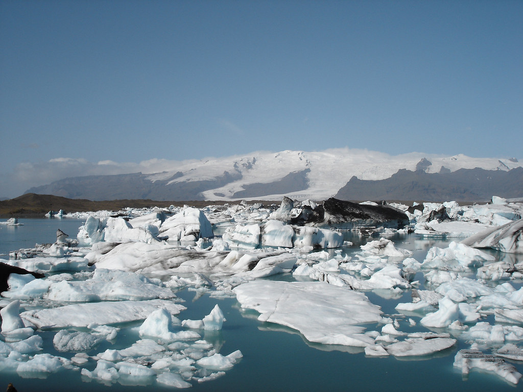
It is another tourist mecca as every tour company stops here.
Heinaberg Mountain, just before Höfn, has sets of basalt columns and a glacial tongue reaching into a lagoon. The 7km long Heinabergsdalur valley used to be damned by glaciers and full of water.
Höfn (pop 1677). This is the largest town in SE Iceland serving as the tourist centre for this part of the park. It has an airport with connections to Reykjavik. It is best known for its lobsters and lovely setting with Vatnajökull as its backdrop.
I picked up a hitchhiker just outside of Höfn, a 17-year-old German kid on the start of his year-long round-the-world trip. It was fun helping him with his itinerary.
The drive to Egilsstadir went through stunning country especially along the gravel shortcut Road 939 bypassing one of the peninsulas on the coast. The Ring Road takes a very circuitous course as it weaves in and out of several fjords.
Eggin í Gleõvik. In the fishing village of Djúpivogur, these 34 huge egg sculptures each represent the 34 bird species in the area. They line the road along the harbour.
Petra’s Stone Collection. The largest private stone collection in the world is in Stöđvarfjörđur.
Egilsstadir was where I started my way on the Ring Road 2 weeks before.
EAST ICELAND
Listed here are some places to see that I missed – all are along the shores of Lagarfijót Lake and then along the valley extending SW from its end.
Hengifoss. This is Iceland’s third-highest waterfall at 128m. It is 34 km from Eglisstadir near the south end of the longest lake in Iceland, Lagarfijót.
Laugarfellslaug. This is a natural hot spring in the highlands.
Snaefell. Iceland’s highest freestanding mountain (1883m) dominates the view from Fijótsdalshreppur just on the north side of Vatnajökull Glacier.
Kárahnjúkar Hydro-electric dam. The biggest dam in Europe is 97kms from Eglisstadir at the end of a paved road.
Fjardararglijufur. This magnificent and massive canyon is about 100m deep and about 2kms long. It has sheer walls, is serpentine, and narrow with the river Fjaora flowing in the canyon down into the Skafta River.
I caught the ferry back to Denmark leaving at 10:30 on August 9. After sailing for 16½ hours, we docked in the Faroe Islands staying for about 44 hours.