
Iceland July 24-Aug 9, 2018
I drove from Amsterdam to Hirtshals, at the northern tip of Denmark to catch the ferry. The 980km drive took me a full 24 hours of sleep and shopping time. The route went east from Amsterdam to Germany and then turned north going around Hamburg and its massive port. I filled with gas in north Germany (at €1.18.9 the cheapest in 5 months) and again in Hirtshals at 9.09K/litre (about €1.35). I also purchased most of my groceries in Germany at Lidl and Aldi, both good value food markets, and purchased a few more in Hirtshals to avoid Iceland prices.
The drive was on fast freeways all the way. It was 351 km from the German border to Hirtshals. Through Denmark, the E45, the main north-south highway, was a fast drive averaging 120-140kms per hour. The road misses all cities and travels through a surprising rolling, agricultural landscape of deciduous trees and golden wheat fields. The crop was just being harvested.
FERRY TO ICELAND
Smyril Ferries. This is a Faroe Island company that runs the only ferry to Iceland. With a 30-minute stop in Torshavn on the way there, it takes 21 hours. And on the way back, you have two days in the Faroe Islands.
At €1537, this could be seen as a ridiculous waste of money (the return plane fare is about €200), but expenses are so high in Iceland that it was very economical. Renting a small car for 22 days was more, a camping van comparable to my California was €3600 and renting a large motorhome €8000. Most of the people I canvassed during the trip paid €2000/week for a camping van. The van gave me a free place to sleep and cook relatively inexpensive meals. And I could see almost all of Iceland. The ring road around Iceland is about 1300 km with several side roads to take to explore.
Schedule.
Hirtshals, DK: Depart 11:30, July 24
Torshavn, Faroe Islands: 17:30-18:00 July 25
Syeorsfjordur, Iceland: Arrive 08:30 July 26. (this is on the east coast of Iceland)
Depart 10:30, August 9.
Torshavn, Faroe Islands: Arrive 03:00 Aug. 10. Depart 23:30 Aug 12
Hirtshals, DK: Arrive 9:30 August 14
The Ferry. This is a large 8-deck ferry with car decks on levels 3 and 4, 3 restaurants, and lots of lounges and sitting areas.
I was astonished by all the extreme off-road vehicles on the ferry – massive tires, truck cabs with odd, boxy campers on the back, totally equipped to go anywhere. They looked like military vehicles. There were many Land Rovers also totally kitted out for an adventure.
Sleeping. It is not possible to sleep in your vehicle and one must either rent a cabin or use a “couchette” – these are tiny 9-bed bunkrooms on deck 2. Showers are provided along with 2 lunches. Bedding can be rented but I bought a sleep sheet, backpacking pillowcase, and sleeping bag for use on the plastic mattress. Access to the car decks is not possible except during the 30-minute stopover in the Faroes, but the vehicles are parked so close to each other that it is likely impossible to open a door (I was at the end of a line and could get my door open). The departure from the boat entailed accessing your vehicle as blocking vehicles departed.
Food. It is very expensive on the ferry – the meal of the day available at lunch was €17.50 and drinks (€2.90 for a coke) and salad bar (€2.70) were extra. Dinner is about €22, a beer €7. There is a duty-free shop with savings to be had on cigarettes.
I brought my food for breakfast but there is no access to a microwave, hot water or any way to prepare your food. Dinners could be salad, sandwiches, boiled eggs, etc. – however, I did not have this knowledge and time to pack between arriving at the terminal and boarding the ferry. Certainly, bring all your drinks.
The food at lunch was excellent – pork or ham, rice, potatoes, vegetables and sauce. One way to scam the system would be to bring a doggy bag to lunch and take extra of the delicious pork or salad for dinner (you could go back for seconds at lunch).
Internet. Wi-Fi is charged for: €7 for 1 hour, €9 for 4 hours or €16 for 30 hours. I have no idea how fast it is. There are several electrical plugs to recharge electronics in the lounge area on deck 5.
During the voyage, there was a talk in English on the Icelandic language and its peculiarities. It is Old Norse brought to Iceland in the 9th century that has been modified as any isolated language would be. Only the Faroe Islanders can understand it. Iceland is concerned about language purity and does not adopt English words for new things but constructs them using their vocabulary.
On the second day, there was an Icelandic movie about two brothers, both sheep farmers and the conflicts that arose when scrapie required them to slaughter all the sheep in the valley.
Torshavn. The ship sailed up a wonderful long inlet surrounded by majestic cliffs and peaks. Many disembarked and boarded.
Day 1
AUSTURLAND (EAST ICELAND)
Reindeer were introduced from Sweden in the 1770s and only exist in East Iceland.
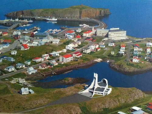
SYEORSFIJORDUR (pop 630)
The Norönna sailed up the 17km long fjord to dock at this pretty but tiny town of coloured wooden houses. Some stopped to get money (the maximum was 40,000 IKA, about €400). It was +7° with a cool wind and lightly raining.
The end road into town goes over a large pass about 28 km to Egilsstađir. Pass several nice waterfalls and a rocky creek.

Egilsstađir (pop 2300). This is the main regional transport hub, and commercial centre and has good services including two busy grocery stores (the prices at Bonus were considerably cheaper than Nitto). I wandered the aisles marvelling at the prices, possibly twice what I had paid in Germany, and was glad I had stocked up. I only had to buy bread.
I used free internet at a local business (in the same building as the information across from Nitto) and did some necessary business.
I decided to go around the ring road in a counter-clockwise direction so headed northwest from Egilsstđir.
As you climb out of Egilsstaōr, pass Rjtikandifoss, a 139m waterfall. The Ysti-Rjtikandi River is one of three with the same name all with a source near Mt. Sandfell. The large fall has 4 cascades as it tumbles off the cliffs above. A short trail leads to the base of the falls. All the low mountains were obscured in clouds.
Eventually, you climb up onto a high plateau. I stayed overnight at a layby with toilets and no No Overnight Camping sign and was joined by three other camper vans and a tenter. Their vans had no refrigerator and a camp stove that was moved out to use – basic vans with a bed converted into “campers” – they had paid €2000 for a small van and about €3000 for one with 4 seats, both for one week. The area had a lovely flowing stream and was green all around. The fellow with the small van had a flat tire due to a sharp rock from the road construction with all the loose gravel – it must have taken him 1½ hours to fix it as all the bolts were so rusted.
Bustarfell. North of the N1 on Road 85 is a farm and folk museum with well-preserved turf houses dating back to 1770. I didn’t go here.
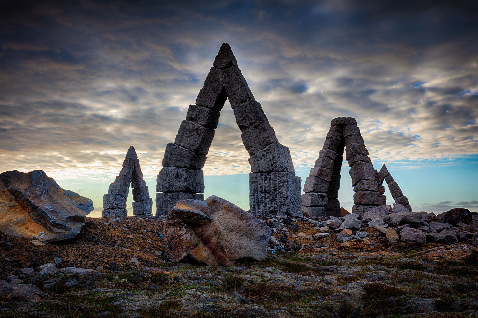
Raufarhöfn, on the NE corner of the Malrakkaslétta Peninsula, is the location of a monumental project taking place on the hillside closest to the town – the Arctic Henge, a series of large, stacked basalt arches placed within circles that act as a sundial to capture the midnight sun’s rays and casting shadows in specific locations. I didn’t go here as it is a big drive off the N1, but it sounds worthwhile if one has the time.
Nearby is the most northerly part of Iceland’s mainland, only 3 km from the Arctic Circle.
Day 2
The N1 continues up to a desolate plateau of lava fields with minimal tundra grasses. Many of the laybys have dioramas describing the history and geography. Down below in the lower valleys, there were a few farms in the late 1800s but an eruption of a local volcano, periods of cold weather climate, and overgrazing spelled their end. The first road was built through here in 1930 and the present paved road was not completed until 2005.
Today was sunny and warm at 12°, but it didn’t last long.
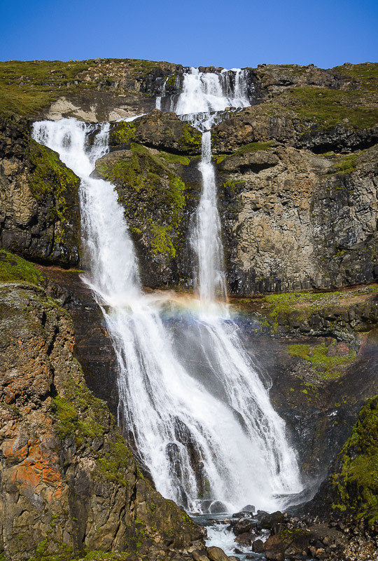
DETTIFOSS. This 45m-high waterfall is a huge wall of dirty grey-brown water cascading off a 100m long diagonal across the Jökulsá River (at 06kms is the 2nd longest river in Iceland originating at the Vatnajökull Glacier. It is supposedly the most powerful waterfall in Europe. From N1, take the good 862 paved road 27 km north. From the large parking area, it is a .8km walk to the west side of the falls, the side with the best views as the diagonal sweep of the falls faces west. There are three viewpoints. Upstream gives the best views of the falls, the rainbow from the huge spray/mist, and the downstream canyon. On the lip of the canyon, it is not possible to see the bottom of the falls because of the huge spray. Above and slightly downstream gets sprayed and gets better views of the downstream canyon.

On the way back, detour .6km upstream to see the Selfoss that falls 10m in a long horseshoe shape.
 Downstream is the 27m Hafragilsfoss; there is a walking trail between Dettifoss and this waterfall.
Dettifoss lies at the south end of Vatnatjökull National Park founded in 2008. The park extends north for 30 km to include Ásbyrgi Canyon, a large horseshoe-shaped depression 3.5kms long, 1km wide, and 100m deep caused by catastrophic flooding of the Jökulsá River. The trail above goes all the way to Asbyrgi campsite.
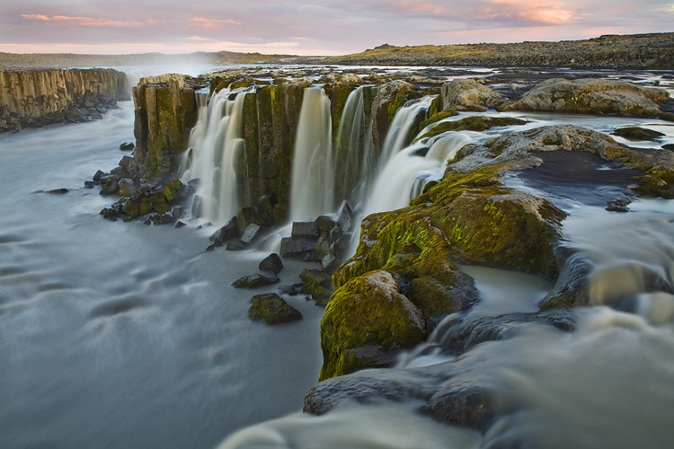
Uverin. 6 km east of Reykjahlid and Mývatn and over a low pass, this geothermal area has some great mud pots and fumaroles with several walking paths snaking through the formations. Climb the good path to the small rocky peak to the west for awesome views. This area sits on the mid-Atlantic rift.
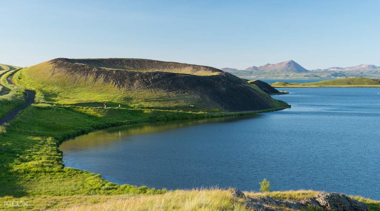
LAKE MÝVATN
A tentative WHS, this is a calm, shallow lake at the heart of a volatile volcanic area with mud pots, craters, lava fields, and fumaroles. It is the 4th largest lake in Iceland at 37.3 sq. km, has a very irregular outline with many islets, and is very shallow, only 4.3m deep at its deepest point. Mt Vatnajökull to the south protects it from southerly winds giving the region some of the best summer weather in Iceland. Most of the water in the lake originates from springs in the bottom of the lake that drains into the Laxá River. The lake is encircled by a 36km paved road.
Reykjahlid is the main village on the northeast corner of the lake.
There are lava formations and the forested lava headland of Höfò in the east, a cluster of pseudocraters on the south at Slitistađir, and great bird watching on the marsh plains on the west (the lake is said to have more species of ducks breeding here than anywhere else in the world).
Hverfell. 5 km east of Reykjahlid is this 1040m diameter, near-symmetrical crater. Take the easy track from the NW corner to the 463m summit for great views of the crater and surrounding landscape.
Dimmuborgir (Dark Castles). This rugged lava field with volcanic caves, chimneys, and pillars has easy walking trails through the formations – the most popular is the 2.3km Church Circle. It is 3kms south of Hverfell.
Mývatn Nature Baths. Northern Iceland’s answer to the Blue Lagoon is 3kms east of Reykjahlid. It has powder blue, mineral-rich waters, and two steam baths. ISK 3500.
HÚSAVIK (pop 2300)
Eleven species of whales, dolphins, and porpoises come to Skjàfandi Bay to feed in the summer and Húsavik has become the whale-watching capital of Iceland. The best time is from June to August. Three companies offer tours into the bay to see whales with a 99% chance of seeing minkes, humpbacks or porpoises, the most common species. Other possibilities are blue, fin, sperm, pilot, sei, killer whales, white-beaked dolphins and harbour porpoises.
The standard 3-hour tours depart throughout the day from 8 am to 8 pm. In season, trips to see puffins on the island of Lundey are possible. Cost is ISK 10,550 to 12,500-18990 to see puffins.
Other tours offer fishing (ISK 16900-49900), trips to Flatley Island to see puffins and whales (ISK 29900), a two-day hike in the local mountains (ISK 99900), horseback riding (ISK 19900), a 2-day yoga retreat (ISK 29900), kayaking on sit-on-top boats (ISK 9900-24900) and day trips to Grimsey Island (ISK 72300).
There were lots of customers (they were doing a whale of a business) and the few I talked to were thrilled that they had seen whales. But these are critter-starved Europeans who pay anything to see wild animals. I have seen whales many times (grey whales in the lagoons of Baja Mexico, the west coast of New Zealand, and all around Vancouver Island where I live) \\and would not pay these sums.
Húsavik Whale Museum. Housed in an old harbour-side slaughterhouse, it shows the ecology and habits of whales, conservation, and the history of whaling in Iceland. Several huge skeletons are hanging from the ceiling. ISK 1900 with concession 1500 if over 67.
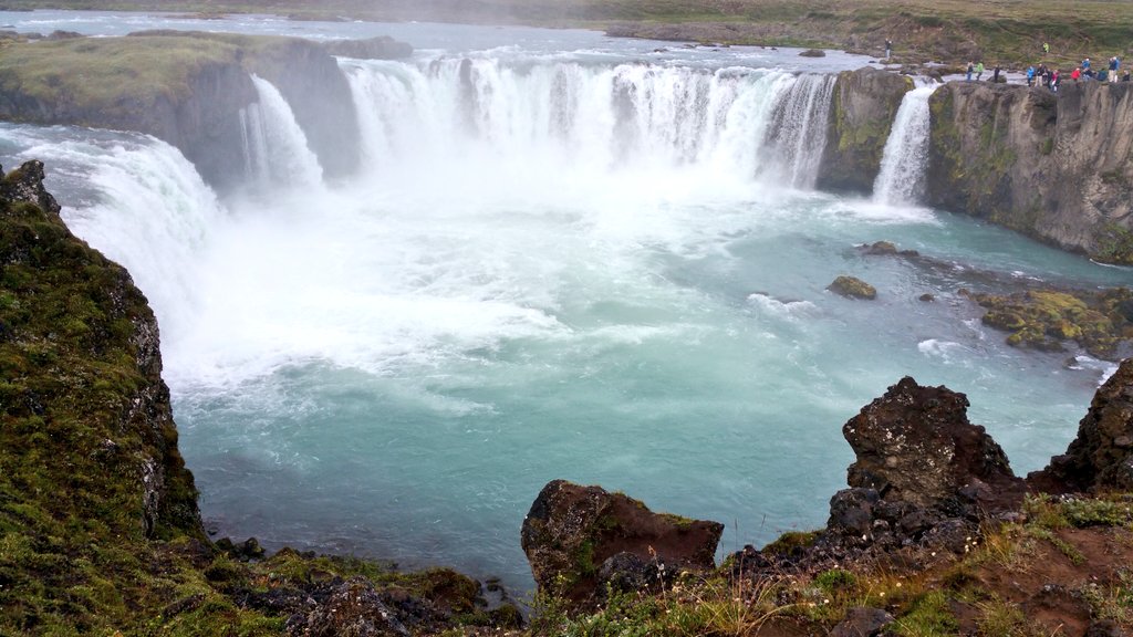
GOĐAFOSS (Waterfall of the Gods). Although it is only 12m high, this waterfall has two long cascades making it very picturesque. The origin of the name came about when the local chieftain in 1000, decided to adopt Christianity and threw his statues of the pagan gods into this waterfall. Just east of where the highway from Húsavik meets N1 is the parking area and then it is a short walk to good views. The river is the Skjálfandafljot, at 180 km, the fourth-longest in Iceland. All the lava surrounding the falls originated at the edge of the Vatnajökull Glacier, almost as far away as the origin of the river.
I stayed overnight at a layby with toilets and no signs on Lake Ljosavatn, about 5kms west of Godafoss.
Day 3
After a night of rain and wind, the morning was a pleasant 12° but then it socked in with moderate rain.
Laufás Heritage Site. North of the N1 on the east side of Eyjafjörđur is this 1865 church and an old turf farm, a gabled farmhouse, and a maze of interconnected rooms including a bridal room. These turf houses are a Unesco WHS.
Safnasafniđ – Icelandic Folk and Outsider Art Museum. 11 km south of Akureyri across Eyjafjörđur on N1. It was opened in 1995 by an artist and his wife in a former elementary school and coop store renovated into 10 separate galleries. They have collected art seen as outside the cultural mainstream and contemporary folk artists from the mid-19th century to the present. The permanent collection on the bottom floor has 70 cardboard buildings, human figures made of reinforced concrete, a large international doll collection, and carved birds by many artists.
Upstairs were embroidered landscapes and several exhibits of mixed quality. She had many drawers of embroidery and textiles and Art Without Borders by disabled artists. I browsed the huge library about visual art design, architecture, textiles, and crafts. They also have a scholar’s apartment. ISK1200
AKUREYRI (pop 18,600)
Iceland’s second-largest city sits at the head of Iceland’s longest (60km) fjord, Eyjafjörđur (island fjord), at the base of many snowcapped peaks.
The city dates to the 9th century when Helgi the Thin, a Norse Viking, settled in the area. The first mention was in 1562 when Danish merchants stayed here. It was recognized as a market town in the 1780s but didn’t blossom until the mid-19th century and since it has become the hub of commerce, production, arts, culture, and education for the north of Iceland. It is big enough to have a good night scene. Spread all over Akureyri are open-air sculptures along the Art Trail.
Hilđarfjall, 5 km from the city and with great views of Eyjafjōrđur, is one of the best ski hills in Iceland. It has fully floodlit main runs necessary in the short days in winter. Kjarnaskogur, 10 km south, is Iceland’s most visited forest with 10 km of mountain biking trails and cross-country in the winter.
HOF Cultural and Convention Centre. This gorgeous, large round building houses visitor information, a bistro, and a restaurant along with the convention centre and concert hall. It is faced with rough vertical slabs of stone and the 3-story foyer has a wonderfully detailed wood pattern.


Akureyri Church (Akureyrarkirkja). Dominating the town from a hill in the centre, this landmark Lutheran church has two large towers. Access by the 90-step wide stairs or drive up and park. Although it was closed, the interior is noted for bas-reliefs on the nave balcony and its lovely stained glass.
Botanic Gardens. One of the northernmost botanical gardens in the world, it has 6600 foreign and 400 native species. The park dates from 1912 and the gardens from 1957 and is a lovely stroll as many flowers are in bloom. The detailed signs are in English. It is about 500m from the church.
Akureyri Museum. The highlight here is the gorgeous house holding the museum – the 1934 villa Kukjuhvoll built as a home by the Ryel family. The home was purchased for the museum in 1962 and is located in the oldest part of the city, about 1.5 km south of the centre. Inside are art and historical items relating to town life, including historical maps of Iceland from 1547-1808, photos, and re-creations of early Icelandic homes. Present exhibitions were on food traditions and scouting.
In front is the first forest nursery in Iceland started in 1899. Nearby is an 1846 simple wood church moved here from Svalbard – a great example of churches built in the countryside during the 19th century.
Motorcycle Museum. About 2kms south of the city, this museum followed the tragic death of Heidar Jonsson in 2007 who left behind his vast collection of bikes and accessories, none that I am much interested in, especially at this price. ISK 1500
Aviation Museum. Located at the airport, it has 28 planes from 1919 to late 20th century jets to one-person hang gliders. There are English write-ups. Free
Hiking. Mt Súlur (1213m). Rising above the SW of the town, a good trail takes 5-6 hours to return.
TRÖLLASKAGI (Troll Peninsula)
From Akureyri, I drove through town and turned north to explore this grand peninsula to the west of Eyjafjörđur. It has the best scenery I have seen so far in Iceland with big mountains, cliffs, and fjords. There are endless hiking possibilities marked by dashed red lines on all the roadside maps.
Hrisey. In, this is the second-largest island off the coast of Iceland and has been continuously inhabited since the 9th century. It is famous for bird-watching as there are no natural predators and 40 native species: ptarmigan is especially common as also arctic tern and eider duck. There is an exhibition on shark fishing and the Holt Museum showcases a typical Icelandic home in the 20th century.
Arrive by a 15-minute ferry from Arskógssandur (one every 2 hours), 35kms north of Akureyri and about 10kms south of Dalvik.
I didn’t go to either of Hrisey or Grimsey but included them for information.
Dalvik (pop 1,367). This is a traditional Icelandic fishing village with a whale-watching tour company and a ferry to Grimsey. In 1934, an earthquake damaged most houses in the town. Johann the Giant (1913-1984), a local man, was the tallest ever Icelander at 2.34m.
Grimsey (pop 61). This 5.3 sq. km island is the northernmost point of Iceland and straddles the Arctic Circle and is 41 km from the mainland. It has a mild climate, rich vegetation, high cliffs around half the island, and 60 species of birds, including one of the largest puffin colonies in the country. The Grimsey church was built in 1867. There are 2 guesthouses, a small store, and a restaurant.
Sæfari Ferry. Departs from Dalvik at 08:30 on MWTF and Sunday and takes 3 hours one-way. Buy tickets on the ferry. ISK 7000 round trip
Fly. Departs five times a week in summer and takes 25 minutes.
From Dalvik, the drive north to Siglufjörđur is one of the most dramatic in the country through three long tunnels. The first is 3kms long, single-lane, and ends at Olafsfjorđur, a charming fishing town. The second 7km tunnel is two-lane and brings you to the stunning, uninhabited Héđinsfjorđur valley. The last farms left here in 1951 – life was difficult with heavy snowfall and frequent avalanches. The fjord is famous for the 1947 plane crash of a Douglas Dakota with 25 passengers that crashed into the side of Hestfjall Mountain on the north side of the fjord. It is the largest loss of life in a plane crash in Icelandic history. I slept here at a lovely layby and stunning views out to the water.
Day 4
I woke up at 3 am to a gorgeous sunrise. I couldn’t see the sun (it rises in the north and my view was to the east) but the high clouds at the end of the fjord were a lovely pink. The rain had stopped, the skies were clear and a warm breeze was blowing – how fast the weather changes here. The third tunnel was 3.8km long and two-lane.
SIGLUFJÖRĐUR (pop 1600). This historic fishing town’s heyday was in the 1950s when there was an astounding upswing in the herring fishery bringing untold riches to the town. Today its appeal is its peaceful isolation and community spirit. It is in the Nomad Mania ‘small towns’ series.
Sildarminjasafniđ – The Herring Museum. In three buildings with exhibitions, it tells the story of the boom years between 1903 and 1968 when the town was the herring fishing capital of Iceland. By 1968, all the herring were gone and had not returned. The minority of herring was sold in barrel pickled in brine (the first building) and the vast majority were made into fish meal for animal fodder and oil (the second building full of machinery and boilers). The third building has boats used in the fishery.
I continued around the north side of the Troll Peninsula. Pass through a short .8km tunnel and then traverse the dramatic coastline. It eventually flattens out into a wide plain that runs up to the mountains. The wind blew progressively harder all day, producing wild white caps and surf on the bits of the ocean I passed. There was little rain but unusual, very low hanging cloud/fog towards the late afternoon.
Drangey Island. Just off the Skagaströnd coast, this small island is a birdwatcher’s paradise as it is a nesting colony for a wide variety of birds, the main being puffins. There is a path to the top of the island along some cliffs that get very close to puffins. The island also served as a hide-out for the longest-surviving Icelandic outlaw, Grettir-the-Strong. He is famous for his swim from the island. I didn’t go here.
Drangey Tours offers 3.5-hour trips starting from Reykir Harbour, next to Grettislaug, a famous hot spring near Reykir Harbour. www.drangey.net +354 821 0090
Hofsos. This tiny town on the west side of the Troll Peninsula has a famous swimming pool, Infinity Blue (900 Kr) on the edge of the cliff. Below is a beach with several cliffs of basaltic columns. The Icelandic Emigration Centre is housed in three buildings on the north side of town. It details the huge emigration when about 25% of the total population of Iceland left for North America. The climate had been getting colder, crops worse and then in 1875, the Askja volcano blew spreading ash over large areas making farming impossible. The northeast of the country saw the most migrants. Most went to North Dakota in the northern USA and many of those subsequently went to Canada where there was more land. About 15,000 went to Gimly Manitoba and it is still primarily composed of Icelanders. It is possible to do genealogy research here but it is complicated by the lack of surnames. ISK 1500
Grof, just south of Hofsos has a turf church with remnants of the oldest place of worship in the country.
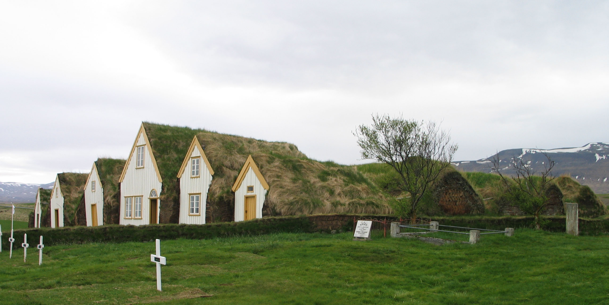
Glaumbær (Skagafjörđur Heritage Museum). The turf farmhouse has been here for 900 years and is part of the Unesco WHS turf houses. The construction is fascinating and best seen in the smithy and store-room as they are not lined with wood walls. A log frame is built and the 1+m wide turf walls are constructed on a rock foundation. ‘Bricks’ of turf are laid at opposing angles on top of each other with each layer of bricks separated by a thin layer of turf. The roof consists of several large thin layers of turf laid on top of wood rafters – about 4 layers on the smithy and storeroom and 10 layers in the house. Long grass waves in the wind on the top. The house consists of about 9-10 adjoining buildings forming a maze of rooms. A complete wood frame with doors in jams and walls makes for an almost normal construction. But the rooms are quite dark as the windows are tiny. Each room has period furniture from the 1900s. The buildings all have a wood gable end. ISK 1700

Borgarvirki. Also known as the Citadel, this is a volcanic plug used by the Vikings as a fortress during times of strife. A wonderful view can be had from the 177m top.
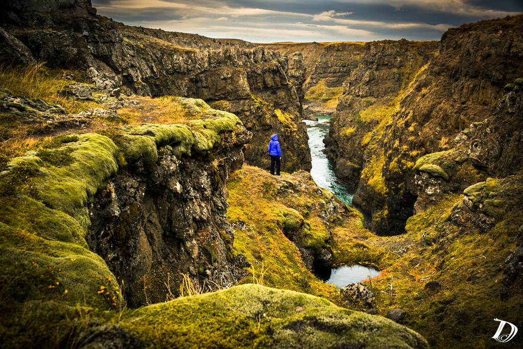
Kolugljúfur. Don’t miss this, a series of waterfalls boiling through a narrow gorge with rugged lava walls. A bridge crosses just at the main upper falls. Walk a hundred metres or so to see the bottom falls and deep canyon. I counted at least 9 separate layers of lava on the walls. Drive 5.7 km southeast of N1 on a potholed dirt road.

The weather turned into dense fog, then heavy rain and strong winds.
Kattarhryggur (Cat’s Arch). I ate and slept at this layby with a toilet beside a lovely stream. Across the stream is the original road for horse-drawn carts and a small stone bridge (the cat’s arch) typical of the first concrete bridges in Iceland. It was used for motorized traffic after 1930 but was very narrow and hazardous. A nice waterfall falls into an alcove above the road. It rained and blew hard all night.
THE STORY OF AGNES
Perhaps the most famous criminal case in Icelandic history involves the brutal murder of Natan Ketilsson (1792-1828) and his guest Pétur Jónsson (1791-1828) when they were fast asleep at his farm in Illugastađir. The farm was ransacked and lit on fire. Natan’s maidservant Agnes Magnúsdottir (1795-1830) and her accomplice Friörik Sigurösson (1810-1830) were found guilty and beheaded in the last execution in Iceland on Jan 12, 1830, in front of 140 locals at Bristoapar. The executioner was their victim’s brother and he gave his fee to the poor. Their heads were put on spikes but mysteriously disappeared shortly thereafter. Another accomplice, 19-year-old Sigriōur Guömundsdötir was sentenced to life imprisonment in Copenhagen where she died of tuberculosis in 1839.
The motive for the crime is unclear but a love affair gone wrong between Natan, a notorious womanizer and both his maidservants, Agnus and Sigriöur was the most plausible. During the trial, Agnes cited her hatred for Natan because of his foul temper and regular abuse as her motive. Court records show that only Sigriõur was romantically involved – with both Natan and Friõrik. Friõrik’s motive may have been hopes of financial gain.
The tragic story has fascinated scholars, artists and writers ever since, who have produced dozens of plays, songs, poems, films, and novels about the case. The most recent is Burial Rites by the American author Hannah Kent.
The story can be visited at several places on the northwest peninsula of Skag: Illugastöir where the murder occurred, Stóra-Borg where Agnes was first imprisoned, Bristapar, the execution site and Tjörn, the burial site of Agnes and Friŏrik.
WEST FJORDS. The largest peninsula in Iceland, it juts out on the NW corner of Iceland. The coastline is serrated with many long and deep fjords, little coastal lowland, and a rocky inland with sparse vegetation. The fjords are separated by high mountains impeding transportation so the road hugs the coastline all the way around. Isafjarđarbær (pop 3,710), at the west end of the peninsula, is a municipality containing 4 residential areas (Isafjörđur is the largest with 2,828 people) separated by tall mountains and connected by a tunnel.
Kaldbakur (998m) is the tallest mountain in Westfjords – the area is called the Alps of the Westfjords.
The sheer Látrabjarg cliffs rise 440m and are the westernmost point of Europe and Iceland.
I didn’t go here – the sinuous drive would have taken 2 days.
Day 5
I woke up to a windy day with clear skies. With a plan to see the Snæfellsnes Peninsula, I turned north to cross a high pass with lovely rugged gorges, waterfalls and cliffs. Descend to a wide flat valley and eventually turn onto? that goes along the north shore of the peninsula. The first 60 km of the road was relatively good dirt with little gravel or washboard but narrow one-lane bridges. The most harrowing experience was passing a bus that took up ⅔ of the road. The scenery was wonderful with rugged cliffs to the left and a bay strewn with flat, grassy islands.
SNÆFELLSNES PENINSULA
The road finally meets good pavement to enter the Snæfellsnes area proper. A jagged ridge of mountains runs along the entire length of the peninsula with Snæfellsjökull at the western end. An extensive lava field extends north, west and south of the mountain.
Breuđafjörđur. This broad waterway and nature reserve separates the Snæfellsnes from the cliffs of the distant West Fjords and is full of grassy islands with great birdwatching. Boat tours are available from many of the towns.
Stykkishólmur (pop 1173). This NM ‘small town’ (the town of a thousand islands) sits at the tip of a peninsula jutting out into Breuđafjörđur. It has a nice harbour and lovely renovated old houses dating from the 19th century. There are several museums: Norwegian House (1833 house, the regional museum), Library of Water (light, glass and water from glaciers) and Volcano Museum. It is known for its nice swimming pool and is the departure point for ferries for the west fjords.
Climb the basalt Mt Helgafell (73m), a culturally famous mountain – an Augustinian monastery was moved here from Flatey Island in 1184.
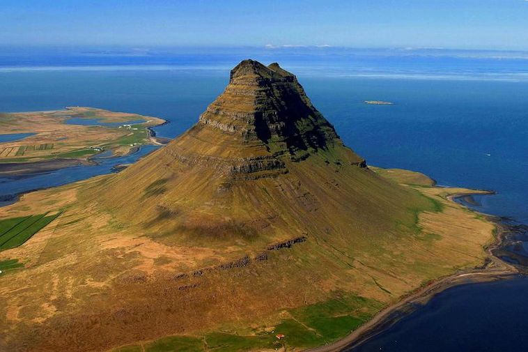
Mt Kirkjufell (463m). The most photographed mountain in Iceland, it sits alone on a peninsula – all shades of emerald green split by many bands of dark cliffs. A diorama describes the geology: a base of tertiary lava, and then 10 alternating bands of sandstone and the cliffs of quarternary lava (reverse magnetism) deposited in the warm periods between ice ages. The top is tuff. It looks like a difficult climb up the south/southwest ridge to negotiate the cliff bands, some at least 10m high but is possible – the down climbing may be more difficult than going up. A 3-hour walk goes around the base.

The fishing village of Grundarfjöđur sits across the bay. It is the capital of whale watching for the Snæfellsnes. The stone sculptures of the artist Liston are dotted all over town.
Olafsvik. This pretty little town has a stunning church with a slanted tapering steeple and a separate bell tower.
Hellissandđur. The Maritime Museum has 2 turf houses. It is also known for its street art.
Saxhóll. This chocolate brown crater was formed 3-4000 years ago and is 109m above sea level. Climb the clever metal stairs to the top – a round metal disc points to all the surrounding mountains and points of interest. It sits in a large plain of rough, old ah ah lava and a similar crater is a few hundred metres north.


Saxhóll has the start of the best route up Snæfellsjökull. Begin on a trail that disappears in the lava but the way is obvious. It is 5 km from the start of the glacier. Travel on the glacier is discouraged unless accompanied by a guide because of crevasses.
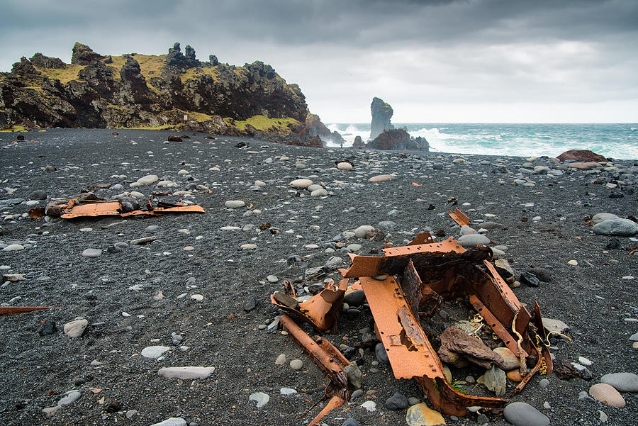
Dritvik. This black sand/cobble beach was the largest spring fishing station in Iceland in the mid-16th to the mid-19th centuries. 40-60 boats employing 200-600 men (farm labour working seasonally in the fishery) worked here in the February to late May season. Four large stones are weighing 23, 54, 100, and 154kgs used to test the strength of prospective rowers in the fishery. The beach is littered with many pieces of rusted metal from the remains of the British trawler Epine which was wrecked in 1948. 14 of the 19 crew died – the only ones who survived had climbed the mast.
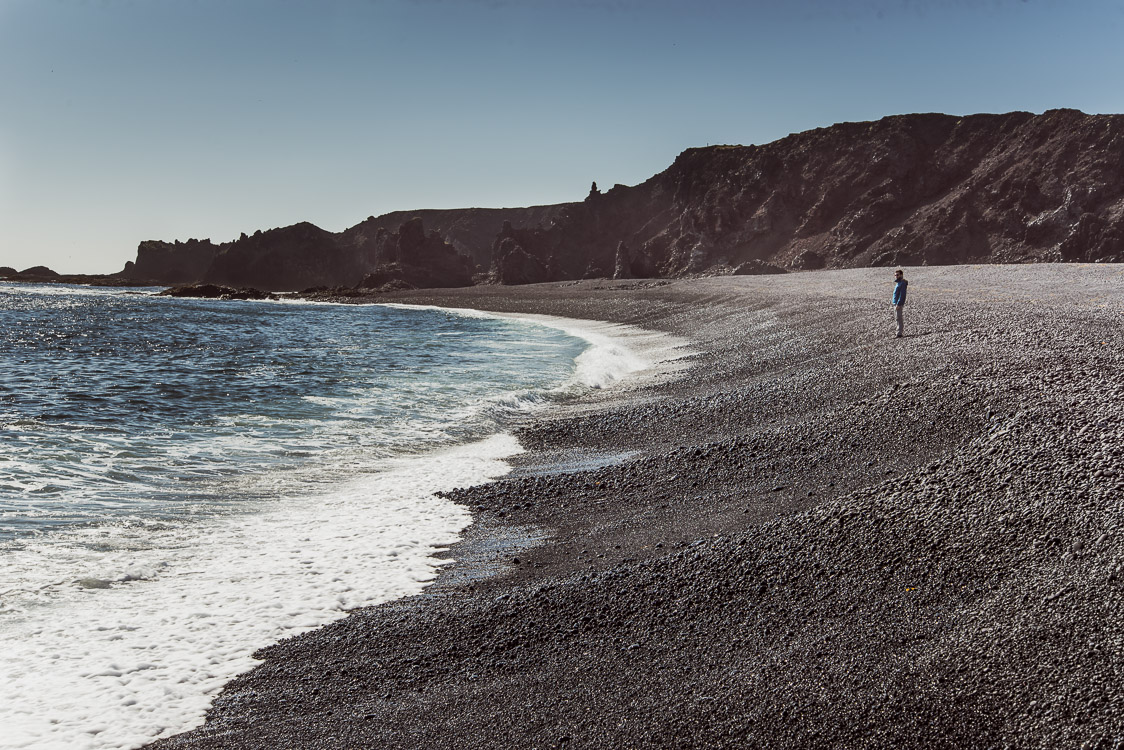
On the way down to the beach, pass rugged lava walls, one with a hole, and two deep pools (Djúpatonsssanđer). This is a busy tourist magnet.
Vatnshellir (The Cave). This commercial operation (ISK37.50) has hourly tours of an upper cave and 3 lower caves with a 200m long, 10m high lava tube. I didn’t do this – the price is extreme.
SNÆFELLSJÖKULL NATIONAL PARK
On the west end of the peninsula and extending to the sea, this 170 sq. km park (formed in 2001) surrounds the dormant volcano Snæfell (3 summits the highest is 1440m) known for its large glacier – in 1900 it was 23km2, retreated during the warm period from 1925-66, expanded until 1996 and since has retreated significantly to 12km2 in 2002 and 9km2 in 2012. The mountain was first climbed in 1754. Outside Iceland’s main volcano zone that crosses the centre of the island, the volcano has erupted 20 times (3 powerful eruptions, the last 1800 years ago) in the last 11,000 years. All the lava fields surrounding the mountain are post-glacial and mostly covered with Icelandic moss, a constant yellow tan, and most likely an exuberant type of lichen.
The Gestastofa National Park visitor centre is at Hellnar and has excellent displays on the mountain and fishery. There are two 71 and 63m high volcanic plugs just to the east. There is a lovely lighthouse close to the visitor centre.
Jules Verne’s novel Journey to the Centre of the Earth is about 2 Germans and an Icelander who go down a crater on Snæfellsjökull to reach the middle of the earth and are finally carried by a volcanic eruption to Stromboli, an active volcano off the north shore of Sicily.
Laugarbrekken. Just east of the park visitor centre, this is an old farm site where Guōriöir Borbjainasdötter was born. With her parents, she made an unsuccessful attempt with Eric the Red to reach Vinland (North America) via Greenland and then finally with her second husband led by Lief ‘the Lucky’ Eriksson settled in L’anse aux Meadows on the north tip of Newfoundland in about 1000 AD. There she was the first white European woman to give birth in North America. There were many difficulties with the local indigenous tribes and she returned to Iceland with her son Snorri. She subsequently made a pilgrimage to Rome and back and eventually returned to Rome where she became a nun. She was the most traveled Icelandic woman until the 20th century.
At the old farm (abandoned in 1881) is a memorial to her with a lovely statue of her and Snorri.

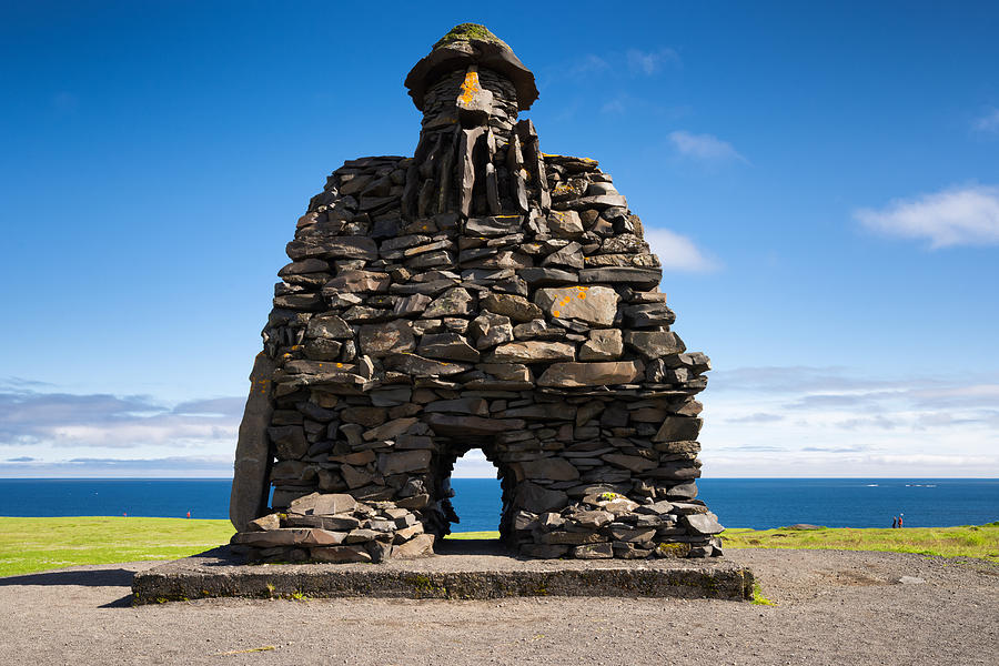
Arnarsstapi. East of the park, this tiny community has a great stone statue of Bárđur Snæfellsás (a mythical figure from the sagas). Walk past the statue to the edge of the cliffs and a lovely walk along the coastal lava field.

Rauđfelđar Canyon. Hike up to this narrow cleft in the rock face with a flowing stream. I was stopped about 30m into the canyon by a 5-foot waterfall topped by a large plug of snow.
The drive along the south coast of the peninsula passes several waterfalls, the most spectacular of which is Bjarnarfoss which drops off the top of a cliff.
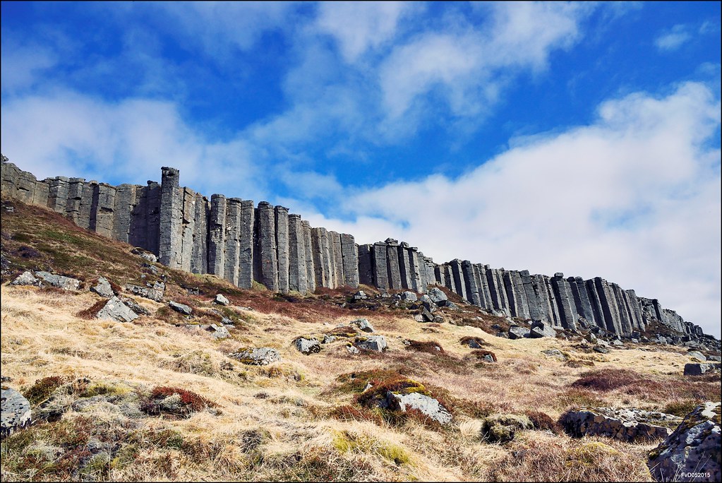
Gerđuberg, just north of Road 54, is a magnificent basalt column wall about 3m high.

I slept just off the road at a quiet layby flying 3 flags. I would have written the name down but it had too many letters.
Day 6
Old Arkranes Lighthouse. Arkranes was the first town to show signs of becoming an Icelandic fishing village when Bishop Brynjólfur from Skalhot started fishing in 1650 and started selling fish products to Europe. In this way, he acquired revenue to fund the Scalholt school. Arkranes is still a flourishing fishing village.
I had a long drive south continuing on Road 54 through the small city of Borgarnes, crossing Borgarfjörđur on a long bridge. Continue south until Melahverfi where there are two possible routes through West Iceland to the Reykjavik area. N1 jogs south and goes through a tolled (ISK 1000) 5.7 km-long tunnel under Hvalfyörđur. Road 47 goes the long way around the east end of Hvalfyörđur, adding several kilometres if going to Reykjavik. I took the tunnel. But as Pingvallir and the Golden Circle were my destinations, taking Road 48 south from the middle of the south side of Hvalfyörđur would not have been much farther and I would have saved ISK 1000.
Day 6 continues in the Reykjavik / Golden Circle post.