
DONEGAL COUNTY May 13-14
INISHOWEN PENINSULA. In the NE of Donegal, it has beaches and towering headland bluffs (Malin, Inishowen, Dunuff and Dunree), mountains in the middle (Sileve Snaght) and the most northern point in Ireland at Malin Head.
Dunaff Head. North of Dunree village, cross the bridge to the Mamore Gap, from the top of which has spectacular views to Dunaff Head. East of the head is the 1.5km Tullagh Strand.
Doagh Famine Village. This outdoor village recalls the struggles of the 1840s.
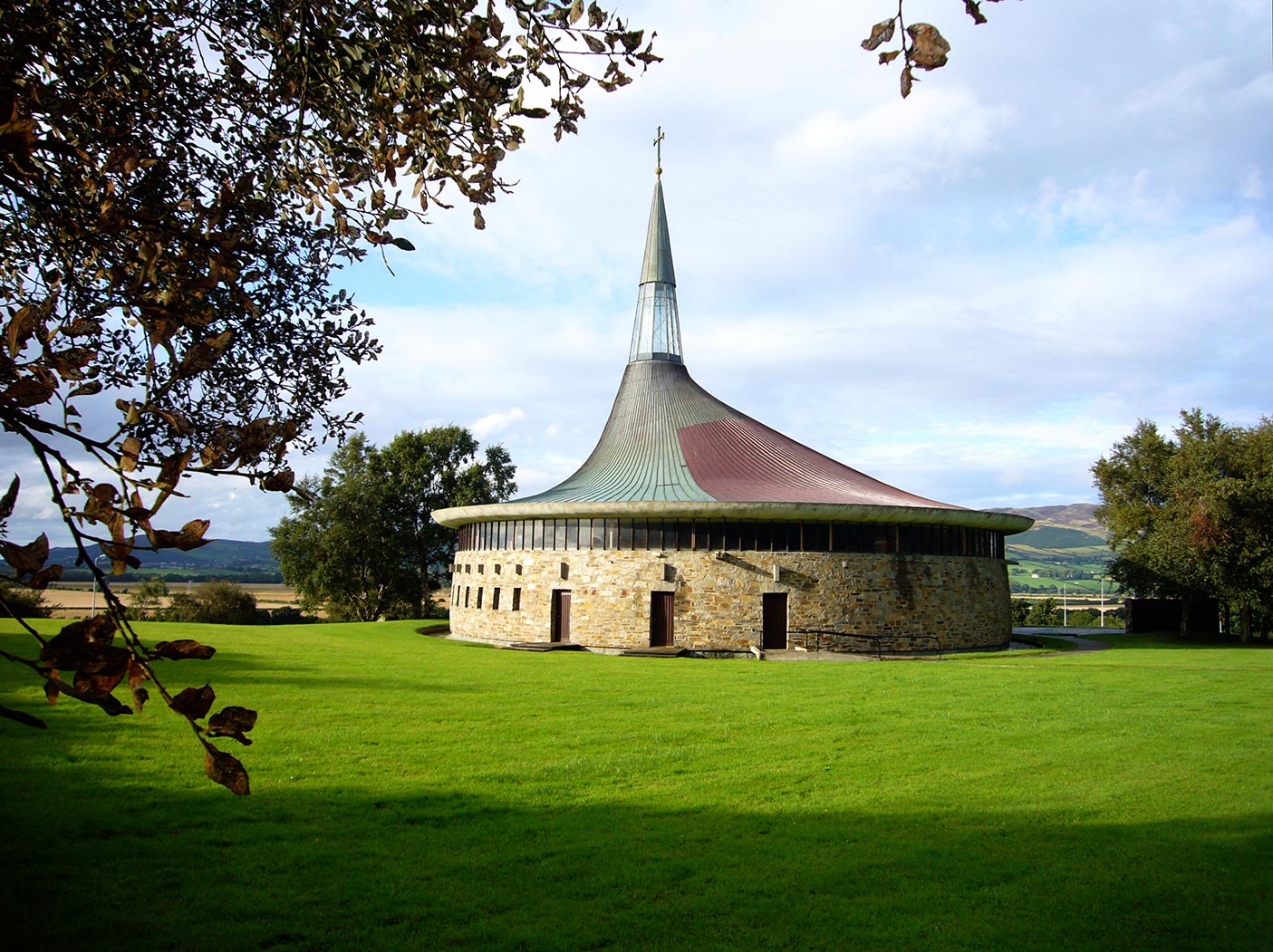
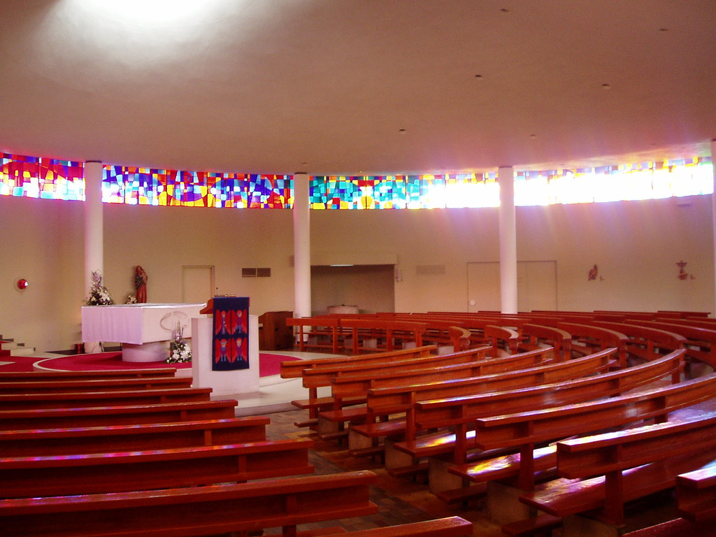
St Aengus Church at Burt. Don’t miss this, the most beautiful church in all Ireland (voted Ireland’s building of the 20th century by a survey of Irish architects) – a new building designed by Liam McCormack. Perfectly round, it has a tall conical spire of glass rising asymmetrically. Inside, the seating is set concentrically and the ceiling rises in a vortex to allow sunlight to beam down directly onto the altar. An equally spectacular meter-high stained glass window caps the entire rock walls. The carved wood Ways of the Cross are as lovely as the church. It is on the N13 Letterkenny-Derry road.
3kms up the hill from Burt Church is Grianán Ailigh, dating from 1700 BC, the base for various northern Irish chieftains, visited by St Patrick in 450, sacked in the 12th century and reconstructed in 1870, it offers great views.
Letterkenny. The largest city in Donegal, I came through here to see Colaiste Ailigh, in the Nomad Mania series, modern architecture. Coláiste Ailigh. This is the VEC’s third all-Irish school first housed in Sprackburn House in Letterkenny. Opened in 2000, it caters not only to pupils from the Letterkenny area but also has pupils from as far away as Fanad, Carrigart, Downings, Creeslough, Termon, and Strabane. In 2013, they moved into their beautiful modern new school building in Knocknamona, the first school under Donegal ETB’s remit to be built under the Public-Private Partnership scheme. The Taoiseach, Enda Kenny performed the official opening of the school in May 2014. The new school has many facilities, including a fully equipped gym, sports hall, cafeteria, and full-sized Gaelic pitch. The school was built to hold 350 students. The school currently has approximately 270 students.
Awards were presented based on achievements in placing PE, physical activity, and sport to the forefront during Active School Week and the school year. It also takes part in the BT Young Scientist of the Year competition and has won many prizes. For example, in 2010 they won second place in the junior group’s category for Biological and Ecological sciences and second place in Senior individual Social and Behavioural sciences. Students are offered a high standard of education through the medium of the Irish language.
Glenveagh National Park. The main attraction here for most visitors is Glenveagh Castle dating from 1873. It was built by George Adair who cruelly evicted 244 people on a cold April day in 1861 to make room for sheep – most ended up in a workhouse. It has nice rhododendron gardens and a view trail above. It is accessed only by shuttle buses from the visitor’s center and by guided tour. I didn’t go. The visitor’s center has great displays. But the real reason to come here is the scenic drive along the A251 through the desolate moor and mountain.
Continue down the Atlantic Way on A56 and R261 highways to Adara. I slept outside of Ardara on a lovely stone pier jutting into the inlet.
Slieve League. If it had not been raining and overcast, this would have been a great mountain to climb. Accessed from the town of Teelin it gives stupendous views of the cliff Amharc Mór. On a clear day, one can see ⅓ of Ireland from the summit.
Instead, I drove to Killeybegs, a fishing port with one of the few deep-sea ports in the country and thus able to host cruise ships. Dunkineely has a memorial to the worst fishing tragedy of Ireland in 1813 when 40 fishermen lost their lives. St John’s Point has a castle with good views over Donegal Bay.
SLIGO COUNTY
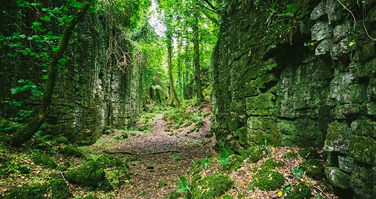
The Glen, Sligo. This was the only Nomad Mania entry for all of Sligo County and it sounded and looked very pretty, so I was determined to find it. Pardon my Scottish? Irish? but I thought a glen was a small running body of water – what we might call a creek, stream, or small river. My father’s name was Glenn and before coming to the British Isles, that was the only glen I knew. But I doubt that this has ever had running water in it, at least not for the last several hundred thousand years. The bottom is flat with short rises of land. It’s a gap about 20m wide running perfectly straight between two immense vertical rock walls. The rock is so vertical and even looks man-made, but it isn’t. I guess that it follows a geological fault line.
Finding it is not easy although Google Maps will bring you to the correct spot. It is on the west side of Mt. Knocknarea. I finally obtained clear instructions from a very pleasant woman in one of the houses along the road. The Glen is on private land and the beginning of the trail is unmarked. Park at the lay-by uphill at a sign “NO DUMPING – MAX. FINE £1900”. I walked 256 paces down the road to the trail heading downhill and going back along the road. Opposite the beginning is a 1m round cement structure that was a water trough for animals.
The trail initially follows an old stone wall with a cement cap that curves to the right at the beginning of The Glen itself. I walked on top of the stone wall to avoid mud. Go slightly left and follow the route between the impressive rock walls for about 15 minutes to where everything ends at a massive tangle of impenetrable bush and more mud than previously. There were a lot of fresh tracks above that stopped here. The trail is very muddy with many braided routes trying to skirt the mud. At about 5 minutes pass through a lovely dry flat area with a large fire pit and two rope swings. There is also a fair amount of tree fall that must be skirted, ducked under, or climbed over.
The magic is the rock wall draped with ivy, large trees, and complete solitude.
After visiting the glen, consider going back via the seaside resort town of Strandhill and Dolly’s cottage, a tiny thatched dwelling with crafts.
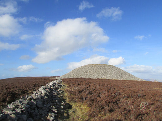
Medb’s Cairn. This massive cairn on the summit of Knocknarea Mountain – 55m wide and 10m high, and surrounded by a 3 m-high earthen bank – is so large it is visible from everywhere around the base of the mountain. It has not been excavated and no one knows who is buried here. It is a 4km climb to the summit from the south but well worth seeing the cairn up close and for the wonderful views north to Donegal and west to Mayo.
Carrowmore Megalithic Cemetery. 4 km west of Sligo town, this site has some 30 megalithic passage tombs, easily the biggest prehistoric graveyard in Europe. They are spread out over a field on both sides of the road. Excavations have uncovered cremated remains and jewelry carved from bones and antlers. £3.50
Skreen Church of Ireland Graveyard. 25 km west of Sligo town along N59, this graveyard has 23 box tombs created by a family of stonemasons, the Diamonds, between 1774 and 1886. The most impressive is that of Andrew Black who had a tomb made for his father in 1825 that has an ornate carving of a plowman, atypically dressed in top hat and tails.
This church is hard to find. Coming from the east, the first graveyard on the road is Catholic. Just west of the signed turn to the north to Aughris, there is a turn to the south for the Ox Mountains and a separate unsigned road that parallels the highway. Take it and the church and graveyard are on the left. The chain on the gate is not locked. Free
MAYO COUNTY
Down Patrick Head. This sea stack is visible from Ceide Fields but is best seen up close. It is neatly layered and tufted with grass. According to legend, this is the severed head of the last snake that St Patrick chased from Ireland.
Ceide Fields. Isolated on the edge of the dramatic cliff on the north coast, this out-of-the-way 5,000-year-old agricultural landscape was miraculously preserved under at least 2m of peat and undisturbed by later farming.
Originally there was a birch/oak forest here that thrived under conditions about 2° warmer than today. Then humans arrived and cut or burned down the forest to raise cattle – they were pastoral people. They constructed houses and miles of stonewalls as corrals – in the area around the museum, they used 250,000 tons of stone lying around after the last ice age. The walls kept some fields intact allowing year-round grazing. Each field was about 3-4 acres in size and the walls extended up and across the hill over about one square kilometre – there were a lot of walls. Other smaller communities and burial tombs were also constructed. There is no evidence of conflict and thus no defensive structures. Then after about 500 years, the climate became colder and rainier and they abandoned the site.
With no trees to absorb the moisture, sphagnum moss started to grow on the base of poorly draining iron pans and charcoal produced from burning the forests. This moss retains water and removes the oxygen from the water so that bacteria can’t survive and the dead plant matter is not broken down in the anaerobic environment – this is how peat is formed in a waterlogged environment. With the increased rain, the peat layer grew steadily – .3m by 2000 BC, .6m by 1000 BC, .9m by the time of Christ, 1.2m by 1000 AD, and today it averages 1.5m in thickness. Peat that forms on hills with some drainage is called blanket peat and is thickest on the top of the hills. Peat that forms in lakes and flat terrain is bog peat and can easily attain thicknesses of 10m. The dry stone structures left by the farmers collapsed and were eventually covered completely by the peat.
In the 1960s, a local farmer discovered some of the walls, and archaeologists arrived. Over the next decade, the walls and houses were mapped by the laborious method of using long probes. Several walls and houses were uncovered completely.
The present lovely museum was built in 1993. It is round with a center that rises to a cone that can be entered for great views around. It has won many awards over the years and recently got the Italian International Carlo Scarpa Prize.
A great guided tour is given on the boardwalk above the museum. After an overview of the terrain, the interpreter gave lots of information. These people were all lactose tolerant, as are most northern Europeans who all kept cattle – milk from the cows was a staple of the diet – and this trait is advanced genetically. He also explained the genetic evolution of fair skin that increases in incidence the further north one goes – fair skin absorbs UV light more effectively allowing for better vitamin D metabolism and calcium absorption. At the top of the field, a demonstration area showed how the probing was done to map the walls.
A diorama in the museum explained climactic cycles and variations in temperatures over hundreds of thousands of years. The earth’s orbit changes from circular to elliptical and back over cycles lasting 96,000 years. The earth’s axial tilt changes from 24.5° to 21.5° over 42,000-year cycles. The earth wobbles on its axis and this varies over 21,000-year cycles. The result is that over the last 700,000 years, the earth has on average been colder than today. Periods of higher temperatures have been relatively short. This explains the main periods of glaciation when plants migrate northward every 10-20,000 years.
Ballycroy National Park. This large 100,000-hectare park is all blanket bog and mountain covering a vast uninhabited and unspoiled wilderness dominated by the Nephin Beg Mountains. Its boundaries are all over the place with several pockets separated from the main mass. It receives 2000mm of rain per year. It is a paradise of alpine heath, grassland, lakes, and wildlife and Slieve Carr (721m) is the highest mountain in the park. The 30km Bangor Trail crosses it from north to south. The Visitor Centre is in the village of Ballycroy between Mulranny and Bangor. We stopped to look at all the displays and had a great introduction by a ranger.
After the small town of Bangor, I picked up a hitchhiker, something that I do at every opportunity, but this was only my second chance in 3 months – people don’t hitchhike and nobody gives them rides. Thomas was a 27-year-old Czech fellow living in Manchester.
ACHILLE ISLAND. He was going to Achill Island (also my destination) to climb Croghaun (665m), the second-highest mountain on the island. This is just above the beautiful Keem Bay with its strip of white sand. I was keen to get some exercise so joined him. Thomas is about 4 inches taller and weighs 50 pounds less than me. Then he left carrying nothing so that he would have less weight. My pack had gloves, a toque, a buff, puff jacket, a rain jacket, and a litre of water – all things I always hike with. Needless to say, I slowed him down some – maybe a lot. But he was pleasant about it and kept to my slow, steady pace. The day had started wet with dense overcast, but by the time we left at 4 pm, it was sunny with little wind. It was a gorgeous climb on the bog and heather. There is supposed to be a trail but we never found it and simply headed straight up following the occasional sheep trail or patches of grass. The small summit was perched above a vertical cliff plunging into the ocean and views to everywhere were sublime.
We descended along the cliff edge and were back at the car in 3½ hours.
Thomas set up his tent on the grass out of the wind and had a supper of a few nuts. I had taco chips and salsa, salad, sausages, and mashed potatoes.
Westport. On the shores of Clew Bay, the town center has an octagonal square and canalized Carrowberg River flanked by a tree-lined mall.
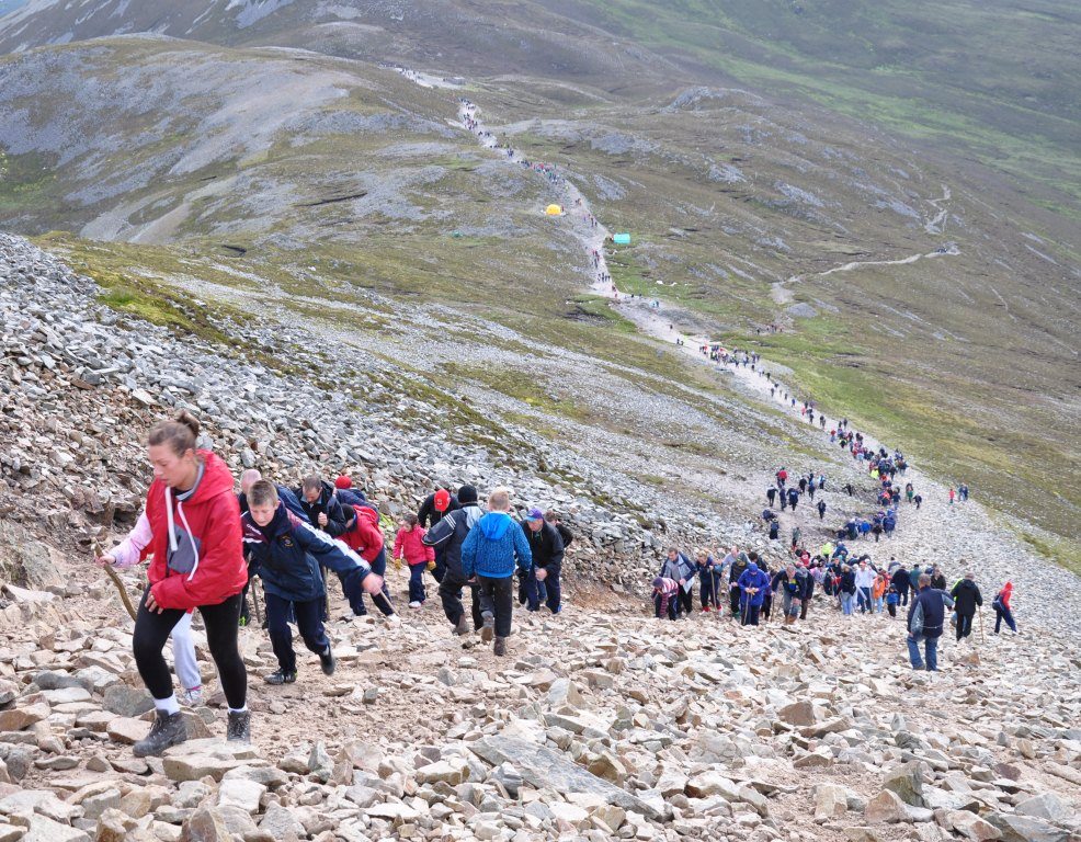
CROAGH PATRICK (764m; Croagh is pronounced “croak”). Halfway between Westport and Louisburgh, this is the holiest mountain in Christian Ireland and easily the most climbed. St Patrick is supposed to have passed the 40 days of Lent alone on the mountain in 441, finding time to hurl all Ireland’s snakes to their deaths over the precipice. This association makes it the focus of major pilgrimages 3 times a year: March 17 (St Patrick’s Day), August 15 (Assumption Day), and the main event, on the last Sunday in July (Reek Day that coincides with the pagan harvest festival of Loughnasa) when tens of thousands of pilgrims attend mass on the summit, some fasting and barefoot. Most nights religious Catholics sleep in the small chapel built in 1905.
The trail. Start at the disappointing visitor center (doesn’t open till 10 am and is really just a private restaurant – only customers can use the bathrooms and the advertised showers cost €5). It offers no information and was understandably empty when I was there at 1 pm. The water in the public restroom near the parking area is not drinkable. Go figure. Maybe the Catholic church should some money into this place.
I got into a huge, but congenial argument with some 20-something Catholic men over abortion and morality. “The Bible is the only objective moral code” and he couldn’t get past the word ‘killing’ in his argument. The abortion issue is coming to a referendum on May 25. Posters plaster every lamppost – again the no vote’s only campaign is “stop the killing”.
For all of its use, this is possibly the worst trail I have ever walked on. After passing through the gate, it is 20m wide, very rocky, and braided all over the place. That improves some above, then pass the saddle and prepare yourself for the steep ascent at the end straight up a very rocky 10m wide path. The only good place to walk is a tiny alley on the side cleared of rocks. Frightened women descend this on their bums. The top has wonderful views north of the water with its multitude of sandbanks and islands and Slieve League in the distance. South are fields and the Twelve Bens.
There were hundreds (thousands?) climbing it on a Thursday in May – mostly kids on school trips and foreign tourists. A priest in his full smock was carrying a backpack to spend the night in the chapel. You would think they would fix the trail by switchbacking it properly, installing water bars, and removing all the rock (look at Walter’s Wiggles in Zion National Park that ascend a cliff). After descending about ⅔, we took the gentler hiker-made ‘heather trail’ to avoid some to the rock but I wouldn’t bother. Despite the sun, it was a cool, very windy day.
After Croagh Patrick, Thomas wanted to climb Mt Mweelrea. So I let him off at the south end of Doo Lough at the side of the road under the seemingly vertical NE face. This whole experience shows what a great experience picking someone up. He was good company and got me climbing some mountains. I plan on seeing him in Manchester at the beginning of June.
GALWAY COUNTY
CONNEMARA. Comprising all of Galway west of the city, it is cut off from the rest of the county by the 40km-long Lough Corrib. It contains two mountain ranges, Maam Turks and the Twelve Bens bordered by the deep fiord of Killary Harbour to the north. The coast is a maze of little islands, winding roads, bogs, and hills where it can be hard to tell small loughs from the sea. Inlets. Clifton is the main town.
Thinly populated and isolated, rural traditions and the Irish language persist. The radio and TV stations are broadcast in Irish and language, and singing and dancing classes are available.
Connemara National Park. This small park covers the northwest corner of the Twelve Bens. The entire park is centred on climbing to the top of the Diamond (445m) or walking the three shorter nature trails across its lower slopes through some natural woodland and over bogland. Six of the Bens form the east and south borders of the park, but can only be easily climbed from that side.
The visitor center has good explanations of the area. The Irish red deer has been introduced after being extinct for 150 years and a herd of the domesticated Connemara pony is also kept in the park.
GALWAY CITY. With few tourist sites, it is the capital of the Gaelic West – it’s the only city in the country where you might hear Irish spoken on the streets. The National University of Galway and the Institute of Technology draw students. Galway is the only coastal city in Ireland that really seems to open up to the sea. Masses of youth were sitting around the harbour.
Galway City Museum. Down by the river and next to the 16th-century Spanish Arch, it traces the city’s history. The highlight is a 9m hooker boat suspended from the ceiling.
Galway Cathedral.
Dunguaire Castle, near Kinvarra on the shores of Galway Bay, is an intact 4-story tower house built in 1520. The name comes from Guaire, the 7th-century king of Connacht who was so renowned for his generosity that his right arm was said to have grown longer than his left.
Galway Cathedral (Cathedral of Our Lady Assumed into Heaven and St Nicholas). This Roman Catholic church is one of the largest and most impressive buildings in the City of Galway. Construction began in 1958 on the site of the old city prison. It was completed in 1965, making it the last great stone cathedral to be built in Europe. The dome and pillars reflect a Renaissance style. Other features, including the rose windows and mosaics, echo the broad tradition of Christian art. The cathedral dome, at a height of 44.2 meters (145 ft), is a prominent landmark on the city skyline. During a controversial interview on Telefís Éireann’s The Late Late Show in 1966, Trinity College, Dublin student Brian Trevaskis referred to the building as a “ghastly monstrosity”. He also accused the then Bishop of Galway Michael Browne of “extortion” over how funds for the new cathedral were raised and implied that the Bishop was a “moron”. More recently, it was described in an Irish Times article concerning “ugly” Irish buildings as a “squatting Frankenstein’s monster” and “a monument to the hubris of its soft-handed sponsors”.
