
ANTRIM & DERRY
North of Belfast, Antrim includes the east and north coast of N Ireland. Derry is simply west of Antrim.
Carrickfergus and Carrickfergus Castle. This has guarded the approach to Belfast Lough since 1177. Beseiged by Scots, Irish, English, French, and Americans (for one battle involving John Paul Jones), it saw activity right up to WW II. The town walls are the oldest and best-preserved in Ulster, surrounding the town center.
The castle was built in 1180 by the Anglo-Norman invader John de Courcy and sits on a rocky promontory above the harbor. It is one of the oldest, largest, and most intact castles in Ireland.
Larne and Larne Museum & Art Museum. With its good port, this is where the P&O Ferry (£119) from Cairnryan Scotland lands – 2 hours. The Stena Ferry, also departing from Cairnryan, lands in Belfast (£155).
The local Museum is housed in the original Carnegie Free Library from 1902 (Carnegie, the American steel magnate finance libraries all over the world), this small museum is typical of most municipal museums. There was an exhibition of Irish dancing dresses. Free
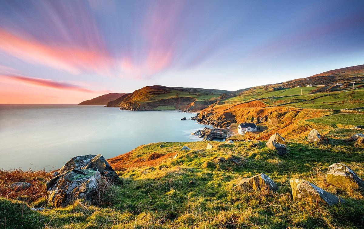
THE GLENS OF ANTRIUM
Northwest of Larne, these nine small rivers descend from rough moorland with lovely seaside villages at their mouths. They are best explored from the Causeway Coastal highway, built-in 1842, and a major feat of civil engineering of the 19th century. 30,000 cubic yards of the cliff were blasted away.
This drive is one of the world’s most scenic following the Causeway Coastal Road. A rock wall is what separates you from the ocean. On the land side is either vertical cliff and rock, steep sheep-infested pasture ending in a cliff, or a patchwork of fields and hedgerow rising partway up the high hills. Every village has a marina, a lovely picnic area on the water, a spate of churches, and a park of some sort lining the glen.
The glens are known for the vibrancy of their Irish culture. It was traditionally easier to get to Scotland by boat than nearby towns by land and it was more often said ‘give me a sail” than “give me a lift”.
Glenarm. Southernmost of the Glens, this small town on the east coast of NI is basically a two-street village. The Glenarm Estate with its walled garden borders the north side. A significant part is the 180-hectare Forest, originally part of the Estate but leased to the NI government since 1928 and managed by the forest service. The one street in town enters the forest at its west end and you immediately enter a tranquil mature forest surrounding the Glenarm River full of birds, animals (including one of the last places with red squirrels, endangered because of the larger grey squirrel), and wildflowers. An unusual plant is a pendulous sedge that can grow to 5 feet. The main trail is the 3.5km ‘Sculpture Trail with four wood carvings of a squirrel, salmon, an 8-foot totem pole, and the ‘spirit of the forest’.
Besides a few shops, there are 4 churches in town.

Carnlough. Sitting on Glencloy, it was based on limestone quarries until the 1960s and its main feature is its sturdy limestone buildings dating from the mid-19th century. A solid stone bridge once carried a railway bringing material down to the impressive harbour. An entertaining diorama discusses the local shinty (or shinny as it is called here) teams. Shinty is like field hockey.
Waterfoot and Glenariff. Waterfoot is a short strip of houses with a few bars. Upstream is Glenariff Forest Park with 4 waymarked trails. the Waterfall Trail has a series of cascades skirted by a timber walkway. Glenariff sits in a wide, lush, flat-bottomed valley that is abruptly cut off by the sea and steep cliffs.
)
Cushendall. 26 miles north of Larne is much more spread out as it sits on three of the nine glens. With wide football fields, a caravan park, and colour-washed buildings grouped on a spectacular shore. The Heart of the Glens festival in the middle of August has music, and sporting events and culminates in a huge street ceil on Sunday.
Cushendun. 5 miles NW of Cushendall, it was a commissioned town built from 1912-1925 with rugged, rough-cast whitewash and slate roofs that weather sea storms efficiently. Much of the town is National Trust Property.
Torr Head. Don’t miss taking the wide single-track road that snakes out to Torr’s head. The main road heads NW to Ballycastle inland passing rough moorland and Loughareema, a lake that drys up in hot weather. The Torr Head road passes Knockacarry and Cushendun at the water then deviate inland to high above the water. A 2-mile loop road detours out to the head with a fairly modern building sitting on its summit. The views back to the coast are stunning. Gorse was in full bloom. It appears to be as much a problem here as on Vancouver Island where it is invasive and controllable only when forest grows over it cutting off the necessary sun. Here they cut it back to form some of the hedgerows. Sheep must also play a role in keeping it under control, one thing we don’t have.
Murlough Bay and Fair Head. The bay is the most spectacular of all the bays on the northern coast with a series of wildflower meadows. Fair Heads 200m headland offers stunning views across to Scotland – the Mull of Kintyre and further to Islay and the Paps of Jura, a proximity that has confused land ownership between Ireland and Scotland. Ballycastle. This is the most northerly of the glens sitting on Glenshesk and Glentaisle. A Franciscan friary was here from 1229 to 1790. The first railway in Ireland was built in 1721 to carry coal to the harbour in 1742. This enterprise came to an abrupt end when the entire deposit caught fire and burned for several years. Other exports included salt, leather, glass, window sashes, and wheat. In 1898 Marconi sent the world’s first wireless signal Ballycastle to East Lighthouse on Rathlin Island.
The best time to visit is for the Auld Lammas Fair, Ireland’s oldest dating to 1606 and held on the last Monday and Tuesday in August. There are sheep and pony sales, dulse and yellowman, a tooth-breaking toffee that’s so hard it needs a hammer to break up.
RATHLIN ISLAND
In 795 Rathlin was the first place in Ireland to be raided by Vikings. In 1575, the mainland MacDonnells sent their women, children, and old people to Ratlin for safety from the English, but he didn’t stop them from slaughtering the entire population. In 1642 a later generation of the MacDonnells was then butchered by the Campbells, causing Rahlin form to be deserted for many years afterward.
This small, 3,500-acre island sits off the coast east of Ballycastle, It is 6 miles by ferry but Rue Point on the island is only 2.5 miles from Fair Head on the Ireland side and also just 13 miles from the Mull of Kintyre in Scotland. With a population of only about 110, it is mostly farms, sheep, cattle, and 4 donkeys in a slightly rolling landscape (the highest point is 447 feet). The tiny village east of the harbour has few businesses other than craft stores.
The passenger-only ferry – £12 return – (cars are only possible if living on the island or by special permission) runs several times a day. With room for about 100 passengers, it was totally booked when I arrived just before the 10 am sailing. But 7 spots appeared. The crossing takes 50 minutes so I had over 4½ hours on the island before my reserved 3:30 return. In that time, it would be possible to walk almost all the trails especially if the bus were taken one way to near the West Lighthouse.
The main attraction is viewing seabirds and the 7 walking routes, The most popular leading from the village to West Lighthouse 4 miles away. Three loops come off the road to follow more natural paths. But it is not wilderness: the route is all on a tarmac road with 2 lumbering buses, local traffic, bicycles, several farms, and a lot of people. But I was there on a Saturday in mid-May, the first nice day in a while. I can only imagine what it might be like in the summer.
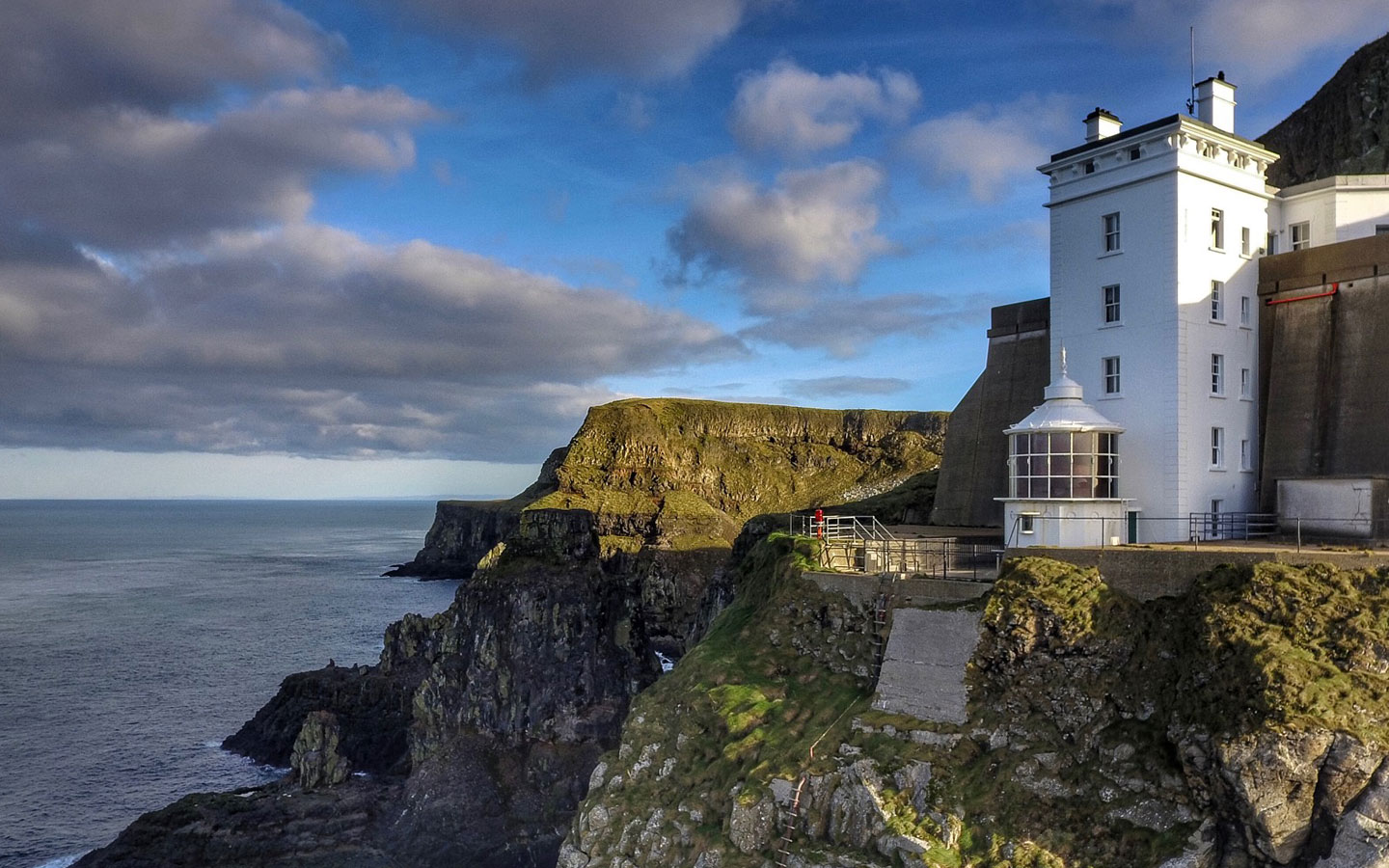
The West Lighthouse is the only upside-down lighthouse in Ireland. There are 5 stories of accommodation/kitchen and then the light, 62m above the water – the perfect height to be seen by ships and usually be under the fog. A massive foghorn audible 20 km out to sea is driven by 2 engines filling 4 massive air storage tanks. The lighthouse was built in 1912 using 62 million kilograms of cement all mixed by hand. Descend a sloping walk and several stairs down to the lighthouse.
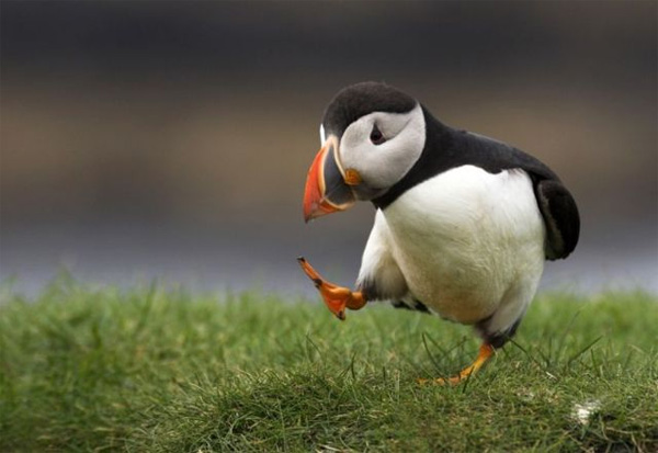
Seabirds are a big draw with puffins always seen between May and July. The RSPB (Royal Society for the Protection of Birds) runs the West Light Seabird Centre where five volunteers man the deck of the lighthouse providing a spotting scope for close-up views of the puffins. About 200 pairs nest here in their ground burrows on the grassy slope just above the water. I could see them easily with my binoculars. Chicks are common in July.
Other hikes are to East Lighthouse and Rue Lighthouse on the southeast tip.
CARRICK-A-REDE ISLAND ROPE BRIDGE. In 1755, salmon fishermen started stringing this rope bridge across to Carrick-a-rede Island to check on their nets. The nets were attached on one end to land and set by boat. In its heyday in the 1800s, up to 100 fishermen worked here. Now salmon have declined to the point they are endangered.
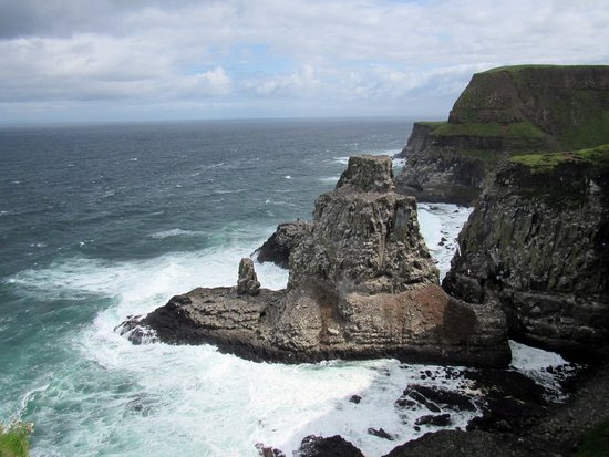
The bridge itself is a little underwhelming it is so short, only 60 feet, but it hangs over a 100-foot chasm, the mouth of an ancient volcano, with the sea below. There is a short walk on the island itself. The real draw is the 1.4km walk along the vertical limestone cliff edge with stupendous views of the cliff, beach, and across to Rathlin Island (with similar limestone cliffs but overlaid by basalt). The bridge is only the gimmick.
The bridge is about 4 miles north of Ballycastle. Avoid the steep £8 fee by coming out of hours when the bridge is inaccessible. This is a hugely popular tourist attraction as evidenced by the large parking area on top and one three times its size in the limestone Larrybane Quarry below. Walk to the headland past the quarry for great views of Stackaboy Island and Rathlin.
Dunseverick Castle. This was once the capital of the old kingdom of Dalriada that spread over north Antrim and Scotland, and the terminus of one of the five great roads that led from Tara, the ancient capital of Ireland. It is possible to walk up to the narrow promontory from the road to the ruins of a 16th-century gatehouse sitting on a very narrow rocky spur, all that remains.
Two men were flying drones here. One took about 100 pictures to make a composite 3D video. Another flew all over the promontory – in the early evening light, you could see the remnants of walls, a round tower, and fields hidden under the grass. Drones have become valuable to show archaeological features not visible from the ground.
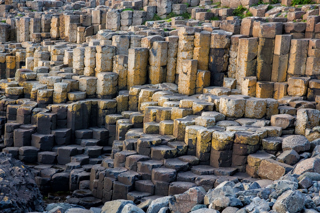
GIANT’S CAUSEWAY
This was first publicized as one of the great wonders of the natural world in 1663 – it has been a major tourist attraction ever since. Highly romanticized pictures were circulated throughout Europe in the 18th century. But not everyone is impressed though, especially with the tourist hype and promotion. It is Unesco-listed and attracts hundreds of thousands of visitors annually.
Chimney Point, a formation further north, persuaded the crew of the Girena, a ship of the Spanish Armada in 1588 to think it was Dunluce Castle and shipwrecked at Port-na-Spánaigh, just before Chimney Point. Its treasure was recovered by divers in 1968 (seen in Belfast’s Ulster Museum and Derry’s Tower Museum).
It is not the height of the black basaltic columns that is impressive (most are flat and well less than a meter high), but the sheer number – an estimated 37,000 – that narrow from about 100m wide on one end to then slowly disappear into the ocean. Giant’s Causeway is the result of a subterranean explosion some 60 million years ago that stretched from the causeway to Rathlin Island and beyond to Islay, Staffa (where it was responsible for the formation of Fingal’s Cave) and Mull in Scotland. A huge mass of molten basalt was spewed out onto the surface, which on cooling solidified into these polygon-shaped crystals – usually hexagonal but sometimes five-sided and sometimes up to 10-sided.
The tallest are best seen from their back (east side) – the 12m-high ‘Organ Pipes’. Other fanciful names (Camel, Wishing Chair, and Granny) have been given to other formations by the guides who plague the site. From this high point, the columns rapidly decrease in size as they disappear into the water.
Giant’s Causeway Visitor’s Experience. This pretty basalt visitor’s centre opened in 2012 for £18.5. Sunken into the ground and covered by grass, it blends into the landscape and provides details on the geological and scientific nature of the site. Look online for the same information and avoid the £11.50 expense – the actual causeway is free 24 hours a day – just walk through the underpass at the corner of the center and descend the gentle kilometre road down the hill.
I would strongly recommend another approach: climb the short stairs at the back of the center onto the top of the overpass and consult the sign that shows the trails – take the one that follows the cliff above the causeway and descend the switchback. If you incline, continue on this trail around to the dramatic headland across the bay. It passes a group of columns set into the cliff face. Then return and see Giant’s Causeway itself.
There are three large car parks and at busy times a park and ride in Bushmills. It is even possible to take the £1.50 shuttle from the visitor’s center down the road. But I would think only disabled people should do that. The walk is grand with a dramatic cliff, ocean, and rocks. The best way to come and avoid the crowds is early in the morning or in the evening when the car parks are empty. I could even have driven my car down the road and stayed the night, but don’t do that.
I arrived at 8:20 pm and walked down in 10 minutes. There were still many people there including a large group of photographers from Chili. I was impressed as all were using half-grad filters to deal with the exposure contrast (rather than taking multiple exposures and stitching in Photoshop). The sun didn’t set until 9:30 and there was still lots of light to have returned at 10. I wished I had arrived by the route over the top of the cliffs. Evening light is best.
COLUMNAR JOINTING
A structure that forms in rocks (most commonly in basalt) consists of columns (mostly commonly hexagonal) that are separated by joints or fractures in the rock that formed when the rock contracted, most often during cooling. Columnar jointing forms in lava flows, sills, dikes, ignimbrites (ash-flow tuffs), and shallow intrusions of all compositions.
Columnar jointing is always a joy to observe in rocks in the field. Stumbling upon perfectly geometric columns of rock can only be described as magical. And it can easily be explained with a little bit of physics.
Most commonly, columnar jointing is observed in basalt. Basalt is an igneous, volcanic rock. “Igneous” means that the rock formed from a melt and “volcanic” means that the melt erupted at the Earth’s surface as lava before it cooled to form the rock. After lava erupts onto the Earth’s surface, it cools. However, lava may take a while to cool, and as it cools there may be a temperature gradient. Most commonly, the top of the lava flow will be cooler than the bottom of the lava flow. Most columns are straight with parallel sides and diameters from a few centimetres to 3 m. Some columns are curved and vary in width. Columns can reach heights of 30 m.
When the lava cools, it contracts. This is because hot things generally take up more space than cool things. When objects contract, they often crack or fracture. When contraction occurs at centers that are equally spaced (see the above diagram), then a hexagonal fracture pattern will develop. If the contraction is not evenly spaced, then other geometries of fractures, such as 5-sided or 7-sided fractures, may occur. Once the crack develops it continues to grow. The growth is perpendicular to the surface of the flow.
Contraction may not be equally spaced if, for example, the thickness or composition of the lava flow varies. The fracture pattern that forms at the cooling surface will tend to be propagated down the lava as it cools, forming long, geometric columns. Thus, as lava cools to form basalt, it may crack in a hexagonal (or other) shape and form columns. These columns form in a variety of sizes– some are fairly small, and some are wider and much taller than people.
Water can play a role in the formation of columnar jointing in lava flows – significantly enhancing it. Where water cooling has played a significant role, often when lava flows are ‘ponded’ in river valleys and are cooled by river water flowing over them, a predominantly two-tiered set of columns can develop, known as entablature and colonnade.
The entablature is probably the result of cooling caused by fresh lava being covered by water. The flood basalts probably damned rivers. When the rivers returned the water seeped down the cracks in the cooling lava and caused rapid cooling from the surface downward. The division of colonnade and entablature is the result of slow cooling from the base upward and rapid cooling from the top downward.
The colonnade columns rise straight up from the basal cooling… whereas the ingress of water in the upper parts of the flow sets up a variety of different angles of cooling fronts. This leads to an irregular and sometimes hackly jointing called entablature in the upper parts of the flow.
Columnar jointing isn’t restricted to basalts. This structure can also form in other types of rocks that undergo cooling and contraction. For example, there is some columnar jointing in the Bishop Tuff of the Long Valley Caldera in California.
There are other conditions (other than cooling of igneous rocks) that lead to the formation of columnar jointing in rocks? Could, perhaps, contraction related to the drying out of a sedimentary rock lead to columnar jointing? Mudcracks, for instance, are often hexagonal in shape.
Classic examples:
Giants Causeway, County Antrim, Northern Ireland
Fingals Cave, Staffa Island, Scotland
Columbia River flood basalts of Oregon, Washington, and Idaho, USA
Devils Postpile, California, USA
Devils Tower, Wyoming, USA
Columnar jointing in Sheepeater Cliff, Yellowstone National Park.
Lesser known examples:
Rosette in the volcanic neck at Rock and Spindle, St. Andrews, Scotland
The Massif Central, France (described by Baron Leopold von Buch)
Moraine Mountain trail, Lake Louise and Banff, Alberta, Canada
Makuopuhi Crater, Kilauea, Hawaii, USA (now buried)
Craters of the Moon, Idaho, USA
Dunsmuir, California, USA
Bishop Tuff ignimbrite, California, USA
Orange Mountains, New Jersey, USA
San Anton, Morelos, Mexico
Cerro Galan ignimbrite, near Antofagasta de la Sierra, Argentina
The intrusion at Rosslyn Bay, Bluff Point National Park, Queensland, Australia
Millstream Falls National Park, Queensland, Australia
The Organ Pipes, in the valley of Jacksons Creek, near Bulla, New South Wales, Australia
Barfold Gorge, along the Campaspe River, New South Wales, Australia
Don Heads, Doctors Rocks, and Burnie, Tasmania, Australia
Shag Head Rock, Avon-Heathcote Estuary, Lyttelton Volcano, South Island, New Zealand
Quail Island, South Island, New Zealand
Mount Bradley, Lyttelton volcano, South Island, New Zealand
Mount Holmes, near Otago Harbour, South Island, New Zealand
Some Observations on Northern Ireland
1. Driving and the Roads. They love traffic circles and get carried away with them – so much so that tiny 2m circles are in every intersection. They are a pain in the ass on major dual carriageways (what we call 4-lane-divided highways in North America) when, especially around cities, they occur every few kilometres forcing you to slow down from 110km/hour to 40 to negotiate the circle. Every side road seems to deserve a circle. This may work well when there is a lot of side-road traffic. In North America, side roads access major roads using stop signs and traffic lights so they don’t impede the speed of major highways.
And on minor intersections with tiny circles, they create the odd situation of cars turning in front of you having the right-of-way as they enter the circle before you – all vehicles in the circle have the right-of-way.
And then on busy circles, they add lights – seems to contradict the idea of having traffic circles at all.
2. Holiday Parks (sometimes called Caravan Parks). These are common and in scenic locations. They consist of ugly mobile homes in semi-permanent locations. Usually single-wides, they sit by the hundreds on blocks side-by-side in endless rows and streets. There are no trees and no attempt to make the site attractive. I guess they answer the poor person’s desire to have a holiday home. They could not be less attractive.
3. The Northern Irish are nice. Their accent is easy to understand. They are very low-key hikers and don’t seem to venture into the mountains much.
Duluce Castle. Just past Bushmills, this promontory has been inhabited since 1500 BC. Converted from a fort to a keepless Norman castle in 1305, it was a Jacobite castle lived in by the clan MacDonnell during the 16th century and abandoned in 1660 after part of it collapsed into the ocean in 1639 during a storm.
I slept just past the castle at a wonderful large pull-off with views of the entire north coast to Donegal.
Coleraine. I only came here as it is a Nomad Mania ‘small town’. A maze of one-way and pedestrianized streets, I had difficulty escaping, but ended up driving around a lot. It sits on a pretty river though.
DERRY
Portstewart. This large coastal resort is full of Victorian boarding houses and is best known for the Portstewart Strand, a long sand beach firm enough to drive on, which the locals delight in doing. Walk the cliffs between the town and the beach.
DERRY CITY
At the foot of Lough Foyle, roads from all cardinal points arrive here. It sits just east of the Ireland/Northern Ireland border. It was a major point of emigration from the 18th century onwards, an exodus that reached tumultuous proportions during the Great Famine. Derry is the fourth largest city in North Ireland. It has a different atmosphere from Belfast, being 2/3 Catholic.
The city appears on maps and road signs as Londonderry or L’Derry. It presents an attractive picture with the River Foyle and two hills topped by stone spires of the ever-present religious denominations and is mostly enclosed within its seventeenth-century completely intact stone walls.
Medieval Walls. A mile in length, they enclose Derry’s compact center. Four gateways allow easy access but an iron screen gets in the way of clear views.
Tower Museum. A reconstructed medieval tower, it has good displays and galleries recounting Derry’s history. £2
Museum of Free Derry. This museum focuses on the decade following the origin of the civil rights movement. On a Sunday, I arrived at 10 am but it wasn’t open till 1 pm. I went to the Tower Museum, ate and slept but it never did open. Very frustrating.