
Isle of Mull & West Highlands May 2-5, 2018
ARGYLLSHIRE
OBAN (pop 8600)
Oban is the gateway to both the Outer and Inner Hebrides (along with Mallaig and Uig on Skye). I arrived here by ferry from Castlebay. Oban is a nice waterfront town on a delightful bay with good views out to Kerrera and Mull. In summer it is mobbed by tourists heading for the islands. It is known for its seafood restaurants.
I had a much-needed free shower at the public facility near the visitor information centre.
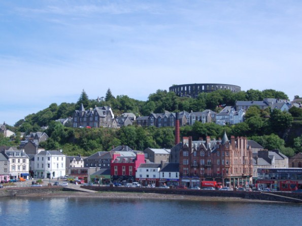
McCaig’s Tower. On top of the hill above downtown, is this Colosseum-like dark stone structure built in 1890 by John McCaig with the philanthropic intention of providing work for the unemployed stonemasons. Climb the stairs from Argyll Street for great views.
ISLE of MULL (pop 2800)
This large island across from Oban has some of the best scenery of the Inner Hebrides: rugged mountains, basalt crags, white sand beaches and granite. Add in Iona, one of the major monastic sites in the world.
Take the ferry from Oban to Craignure (£17.80 every two hours). I slept near the ferry terminal near a rocky pier. After the previous nice day, May 3rd was grey, heavily overcast and raining all day.
Duart Castle. The ancestral seat of the Maclean clan sits on a spectacular outcrop overlooking the Sound of Mull. Originally built in the 13th century, the Macleans supported the Jacobites and the castle was taken over in 1745 after the disastrous Battle of Colloden by the Campbells who abandoned it and it fell into ruins. It was finally purchased by a Maclean in 1905, restored and reopened in 1912. There are dungeons, a courtyard, battlements with great views and a lot of clan history. It details Lachlan Cattanach, who took his wife on an outing to an island in the strait, then left her there to drown when the tide came in.
The castle is reached on a 3km single-track road off the A849 west of the ferry terminal.

After the castle, the single-track A849 is truly desolate – high mountains, barren moor, rocky creeks, no farms and not even a sheep – until passing the turnoff to Salen when farms become frequent and you drive along the rocky shores of Loch Stridain all the way to Iona. On the long peninsula of the Ross of Mull, pass through the tiny hamlets of Bunesson and Uisken to Fionphort to catch the ferry over to Iona (£5.20 return every 30 minutes).
IONA (pop 200)
This holy island and burial ground of kings is famous for the Iona Abbey. St Columba sailed from Ireland and landed on Iona in 563, establishing a monastic community with the aim of Christianizing Scotland. It was here that he wrote the Book of Kells – the prize attraction of Dublin’s Trinity College. It was taken to Ireland for safekeeping after the Vikings started to raid at the end of the 8th century.
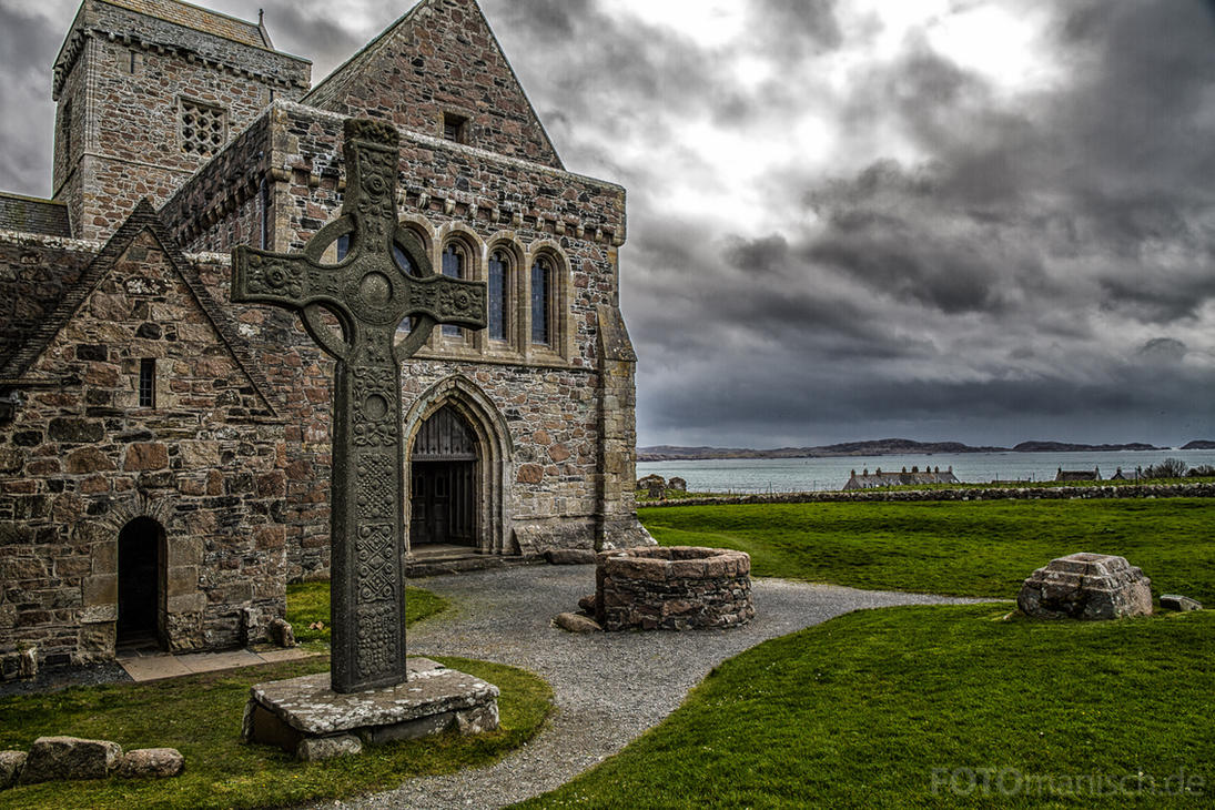

The community was re-established in the early 13th century and prospered until its destruction during the Reformation. The ruins were given to the Church of Scotland in 1899, and by 1910 a group of enthusiasts called the Iona Community Council had reconstructed the abbey. It’s still a flourishing spiritual community offering regular courses and retreats.
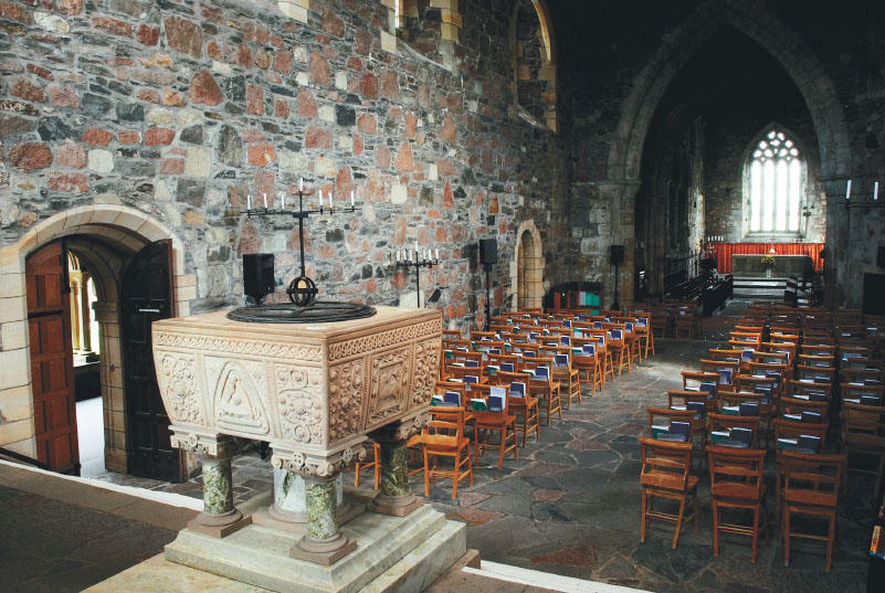
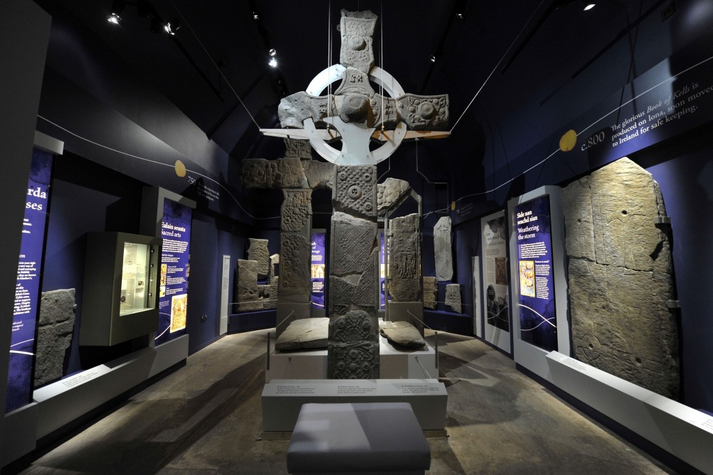
The nave of the abbey is dominated by Romanesque and Gothic vaults and columns. Next door is the beautiful cloister with wonderful carvings on the columns and grave slabs lining its walls. The museum displays fabulous carved high crosses, statues of knights and inscribed stones. A replica of the intricately carved cross of St John stands outside the abbey. The graveyard has a chapel and mound that marks the burial place of 48 of Scotland’s early kings including Macbeth. The ruins of the nunnery nearby was established at the same time as the Benedictine abbey.
Also, visit the Iona Heritage Centre with the history of Iona and crofting.
Climb Dun I, Iona’s highest point, an easy 15-minute walk on a path past the abbey. There are great panoramic views.
Carsaig. I had read about the nice sea arches here and decided to drive the 4-mile road to see them on my way back from Iona. The sign “Weak Road” lived up to its reputation: very narrow, few passing places, potholes and grass growing down its centre. Pass through wonderful mature forest and moss-covered walls at the beginning and end.
As you approach the water at the road’s end, pass a stunning waterfall, some big houses down on the water with “No Public Access” signs, and take the road to the Power House, now a BnB. Continue the steep descent to the pier and park at a small parking area. I was tempted to remove the steel post in the centre of the track and sleep on the pier. I went for a walk along the road hoping to see the arches, passing the Pier Cottage and The Library (both rental properties) and turned onto the Coastal Path. Muddy in places, I walked for 10 minutes to a headland with no signs of the arches, stopped in at the Library and asked where the arches were – “The other direction”.
It was 7 pm so I camped there and had a lovely night with the crashing of the surf outside. On the return drive, the Carsaig Estate had two big houses and ruins. Four nice waterfalls cascade from the cliffs above. There were 7 big red deer in the field on my way out. I never did see the arches.
Back at the road, I turned north on the ‘Scenic Road’ to Salen in the overcast and rain. If you have the opportunity, don’t miss taking this narrow single-track as it is unbelievably scenic hugging the coast and passing numerous waterfalls and glens for most of the way. In the early morning, there was no traffic and I dodged more cattle and sheep than cars. OMG the lambs are cute – little black faces and legs – they are the most aggressive nursers, jabbing at mom’s teats before latching on.
I arrived at the Craignure ferry to return to Oban at 08:25 – the ferry had arrived at 08:20 but had loaded all the cars and lifted the gangplank. All the passengers then walked off and then all the boarding passengers walked on. They refused to let me on and gave me a big lecture that I should have made a reservation and took great relish in telling me that the next four boats were fully reserved and that I had to wait in standby. They picked up the ferry timetables and said it’s easy, just make a reservation. I said I didn’t know when I would return for sure and never make reservations on the ferries at home. Rude assholes. I went in and made a reservation for the 13:30 ferry to ensure a spot and got another big lecture that everyone knows to make a booking.
Despite all the islands in the Inner Hebrides that can be visited – Coll and Tiree west of Mull, the intriguing-sounding Rum, Eigg and Muck to the north, and Colonsay, Jura and Islay to the south, I elected to turn along Loch Linnhe northeast from Oban to visit Fort William and Ben Nevis, Scotland’s highest mountain.
WEST HIGHLANDS
This region extends for the bleak blanket-bog of the Moor of Rannoch through Glen Coe and Fort William west to the coast and includes the southern reaches of the Great Glen. It was designated the Lochaber Geopark in 2007, an area of outstanding geology and scenery.
FORT WILLIAM (pop 10,000)
At the inner end of Loch Linnhe, this is the only sizable town in the area and set amongst magnificent mountain scenery, earning it the reputation of the ‘Outdoor Capital of the UK’. It has one of the highest rainfall records in the country and it didn’t disappoint when I was there.
West Highland Museum. This small museum is packed with Highland memorabilia. Some highlights were the display on the Commandos, an elite army corps. Look for the secret portrait of Bonnie Prince Charlie (after the Jacobite Rebellion, all things Highland were banned) and this tiny painting looks like nothing more than a smear of paint until viewed in a cylindrical mirror that reflects a good image of the prince.
Glen Nevis. It begins near the north end of town (only an hours walk from the town centre) and wraps itself around the southern flanks of Ben Nevis. The Visitor Centre is 1.5 miles up the glen. Drive past here for an excellent 1.5-mile walk through the gorge to Steall Meadows and a 100m bridal-veil waterfall.
The glen is popular with movie makers and parts of Braveheart, Rob Roy and the Harry Potter movies were filmed here.
Ben Nevis (1354m). Britain’s highest mountain, it is climbed by 100,000 people every year. The summit often has snow and is obscured in cloud 90% of the time. The tourist track (originally called the Pony Track built in the 19th century to carry supplies to the meteorological observatory on the summit used from 1883 to 1904 and now in ruins) starts from the Visitor Centre and climbs gradually before steep switchbacks ascending the 700m cliff surrounding the mountain to the summit plateau (8 miles return, 6-8 hours). There are two other possible starting points: Achintee Farm or the footbridge at Glen Nevis Hostel.
Road to the Isles. The 46-mile road from Fort William to Mallaig marks the beginning and end of Bonnie Prince Charlies doomed attempt to regain the British throne in 1745-6. Instead of the new fast road, opt for the more scenic Alternative Coastal Route. North of the road lies Scotland’s ‘Empty Quarter’ – Knoydart and Gleneig.
Ferries depart from Mallaig to the small isles and one to Lochboisdale on South Uist in the Outer Hebrides.
My original ferry from Lochboisdale was supposed to arrive in Mallaig but the ferry used was too large for the Mallaig berth and instead went to Oban so I was unable to drive this road.
Coin-operated laundromats are a rare commodity in Scotland and I was desperately in need. Caol Laundrette is an excellent one about 3.5 miles from downtown Fort William in the Caol Shopping Centre. Washing machines in Scotland are unbelievably expensive – the one in Kirkwall was £6 and this one was £5 but the dryers were a reasonable £1.50. I met a couple here from California who had done the Coast-to-Coast Walk and had just finished the West Highland Way (they used baggage carriers for both).
I also was able to buy all the Lonely Planets for the rest of Europe – Belgium & Luxemburg, Netherlands, Scandinavia and Eastern Europe. They are a big expense but one that is invaluable in seeing anywhere. I mark and make notes on all the Nomad Mania sites in them and mark them on the maps so that I have everything in one convenient place. Combine these with Google Maps and finding anything, missing little is relatively easy.
GLEN COE. On my way to Glasgow, I drove SW down the A82 along Loch Linnhe for 20 miles and turned SE up Glen Coe. Glen Coe is Scotland’s most famous glen and one of its grandest, even in bad weather. Past Glen Coe Village, it passes deep gorges, waterfalls and magnificent mountain scenery into the upper glen over the Pass of Glencoe. The south is dominated by the 3 massive Three Sisters, mountains, and the north side by the continuous steep wall of knife-edged Aonach Eagach. Two miles before the ski hill (Scotlands first in 1956), consider turning SW along peaceful and beautiful Glen Etive 12 miles to the head of Loch Etive. The river has several pools on a hot day and numerous picnic sites.
To explore the desolate area within Ben Lawer National Nature Reserve west of the A82 between it and the A9, consider the following drives accessed from the A85 and then the A827 between Crainlarich and Ballinluig that goes on the north side of Loch Tay.
Loch Tay. This is the heart of the West Highlands. Ben Lawers (1214m) looms over the loch and is the highest peak outside the Ben Nevis and Cairngorms regions.
Glen Lyon. The longest, loneliest and loveliest glen in Scotland, the 32 single-track miles of stone bridges, woodland and heather-clad hills ends at the dam on Loch Lyon. There are no villages and only majestic scenery. Pass the memorial to Robert Campbell (1808-94), a Canadian explorer and fur trader who was born in the glen.
If heading east on the A827, turn north past the west end of Loch Tay and take the steep and spectacular road crossing the hills to meet the Loch Lyon road at Bridge of Balgie where there are a few houses. If coming from the east, access the Loch Lyon road at Fortingall.
LOCH LOMOND
This is Britain’s largest loch and after Loch Ness, the most famous. Only 30 minutes north of Glasgow, it gets crowded in the summer. The West Highland Way follows the eastern shore and the west shore has a busy, but slow, very winding road. North of Luss, it is narrow occupying a deep trench gouged out by glaciers with 900m mountains on both sides. The south is broad, full of islands and fringed by woods and meadows.
Loch Lomond is the heart of Loch Lomond & Trossachs National Park, Scotland’s first in 2002. Because of the length of Loch Lomond and the Trossachs are on the east side, the park can only be accessed from the north via Crainlarich or the far south at Drymen.
A cycleway links Glasgow to the south end where it joins another path that continues for 10 miles to Tarbet.
Cruise boats are common and offer trips to Rob Roy’s cave and Arklet Falls. Canoes can be rented to explore the islands.
Climb Ben Lomond (974m) from Rowardennan, a popular and relatively straightforward climb. Take a boat across the lake and if you have the energy, then hike 9 miles of the West Highland Way.