
The drive along Scotland’s far northern coastline is one of the world’s finest road trips. Cross desolate moorlands, mountains, stunning coast, and white sand beaches. The round trip from Inverness is roughly 500 miles and has been dubbed the North Coast 500. Most will drive more to reach coastal vistas at the end of dead-end tracks.
After getting off the ferry from Orkney at Gills, I turned west to head along the north coast.
Dunnet Head. This is the most northerly point on the British mainland (3.5 miles further north than John O’Groats and only 6.71 miles from the south end of Hoy Island in the Orkney. Dramatic cliffs drop into turbulent Pentland Firth. It is seabird heaven and has another Stevenson lighthouse built in 1831.
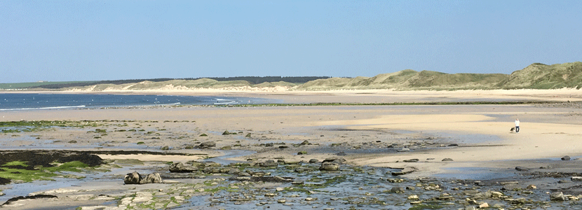
Dunnet Bay. Just west of the headland is this huge curving chunk of sand, one of Scotland’s finest beaches.
Thurso (pop 7600). Britain’s most northerly mainland town, it has a pretty beach and riverside trails. Ferries for Stomness on Orkney leave from Scrabter, 2.5 miles to the NW.
It is 80 winding – and most spectacular coastal miles from Thurso to Duness. Initially, the sun was out and views across the green fields down to the ocean were spectacular. But the cloud soon returned.
Although you might think this would be a good secondary highway, from Bettyhill to Tongue, most were one-lane making for very slow driving. You don’t want to meet another car at speed on the twisty road with no sightline. But it was beautiful – hills covered with brown heather, yellow-flowered gorse lining the road, small lochs, open range with shaggy highland cattle and sheep, and occasionally openings to panoramas of a coastal cliff, bays, and beach. Coldbackie Bay was particularly gorgeous. The diorama on the lay-by was written by a real wordsmith. To the south were craggy mountains with snow patches and hidden by sheets of rain. Rare farms with green fields laced with rock walls added some colour. The only trees were small patches of plantation forest. Scoured granite punctuated the brown heather.
The drive around Loch Eriboll (actually a large inlet from the ocean) was stunning, again on a single-track road that rarely allowed speeds over 50km/hour. Everyone passed gives a friendly wave. The road opened up high above a wonderful beach on the west end of the inlet. The Golden Eagle Zipline crosses over the east end of the beach (£12) but there was no one there to run it. An Arctic tern posed on a rock in front of the van.
Smoo Cave. At the eastern end of the tiny village of Duness (pop 400), is this large limestone cave with stairs leading down to it on either side. Used as long as 7000 years ago, there is a midden, stone house from the 18th century used by fishermen, and a winch to haul boats above high tide. The Norse were here 800 years ago (smoo is derived from the Norse smúga) and fishermen used the inlet for fishing in the 20th century. A tannin-stained stream coming down from the large Loch Meadaigh well above disappears in the back of the cave and then produces a waterfall into a pool accessed by a short walkway at the side of the cave. The inlet is long, narrow, and flanked by steep granite cliffs. Tours for £5 cross the pool and enter the third part of the cave. There are no tours in heavy rain or with a strong SW wind that drives water down the lake.

Cape Wrath. This is the remote northwest point of the British mainland. To get here, turn NW just south of Duness and take a passenger-only ferry (£4.5) across the Kyle of Duness that connects with the Cape Wrath Minibus (£12 return) that runs the 11 miles to the cape in 40 minutes. The ferry runs erratically twice daily from April to September. The Cape is crowned by another Stevenson lighthouse and close to the seabird colonies of Clo Mor, Britain’s highest coastal cliffs. I didn’t do this as it was very late in the day.
DUNESS TO ULLAPOOL
The drive 69 miles from Duness to Ullapool is perhaps Britain’s most spectacular road – A838 that goes southwest of Duness goes through a stunningly beautiful landscape – stark grey Lewisian gneiss, drab brown heather and strips of yellow grass – all punctuated by glens and lochs, mostly small but some large. The grey skies and cloud/mist-covered hills and mountains (Foinaveb and Arkle mountains are to the southeast) add to the sombre colour palate. Geologically, this is the oldest rock in Britain. Further on pass other through the Torridonian sandstone mountains of Assynt and Colgach including Suilven (732m) and Stac Pollaidh – the area has been named the Northwest Highlands Geopark.
At about 55kms above Ultapool, the road finally becomes two-lane again. Large fiords with stunning views are passed at Loch Laxford and on A894 at Scourie. Splotches of yellow gorse appear at lower elevations. At 7 pm I decided to stop, eat and sleep at a large parking area just before the lovely curving Kylesku Bridge (built in 1984 and opened by the Queen; it replaced a ferry that had operated since the 19th century) crossing signed Caolas Cumhann (Loch á Chairn Bhain and Glencoul on the map), one of the largest fiords on the west coast.

As I was writing this sitting in the front seat, two big stags walked into the parking lot and ate 10 meters in front of my vehicle – grey with a white rump and a brown shaggy neck, long legs, and 4 prongs on each antler on the larger, 3 on the smaller. This caught me totally by surprise – you just don’t expect to see wildlife in Europe, but this was a truly desolate country. It is always surprising how oblivious wildlife is when you are behind glass. When I opened the window to have a smoke, Pink Floyd made them disappear over the bank and descend to the water. Later, just before dark, another male and a female were also below the bank and another big stag was on the bluff across the road.
Eas a ‘Chuil Aluinn. Five miles SE of Kylesku in a wild remote country is this 213m high waterfall, Britain’s highest. Hike to the top of the falls from a parking lot at a sharp bend in the main road 3 miles south of Kylesku. Cross a veritable swamp at the beginning and cross the outlet stream of the loch on rocks. The trail across the north of the loch is likewise very wet. Scan ahead for the easily located trail that becomes quite rocky. Eventually, another loch is reached and the trail levels across the north end. On reaching the top of the ridge, the underwhelming waterfall appears across a gorge. I descended partway to an elevation roughly equal to the top of the falls rather than go all the way down to the side of the gorge. It was only possible to see the top of the falls. They are fed by a small loch from above and are more of a cascade than a free-falling waterfall. The falls are apparently better seen by boat from the end of Glencoul. A bothy (free hut) is near the bottom of the falls.
Assynt. Just past the bridge, take B869 for 23 miles on a narrow road to see this area of isolated peaks and lochan. Glaciers sculpted the hills of Suilven (731m), Canisp (846m), Quinag (808m), and Ben More Assynt (998m). Reach the lighthouse of Stoer with a 1-hour cliff walk to the Old Man of Stoer, a spectacular sea stack. South is Lochinver, the main settlement and busy fishing port.
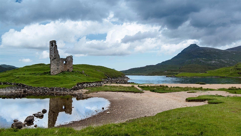
Ardvreck Castle. On a peninsula extending into a large loch are the ruins of this 4-story castle built in the latter half of the 15th century by the Macleods. Their ownership of Assynt ended after a 12-day siege from the MacKenzies. The end of the castle occurred when struck by lightning in 1795. There are all sorts of old findings here including a horizontal grain mill and a millstone. A 9-hole golf course, now disappeared, was built here during WWI.
Colgach. South of Assynt and west of A835 from Ledmore Junction to Ullapool is this area of wilderness. Get there by driving south of Lochinver on a scenic backroad so narrow and twisting it’s nicknamed the Wee Mad Road. This road reaches a T-junction on a road that heads west of A835 along Loch Lurgainn. Mountains include Cul Mor (849m), Cul Beag (769), Ben More Colgach (743m), and Stac Pollaidh (613m). The main settlement at the end of the road is Achitibuie with the gorgeous Summer Isles just off the coast.
At Ledmore Junction, I turned SW on A835 heading to Ullapool.
ULLAPOOL (pop 1500). This pretty port on the shores of Loch Broom (another fiord) is the largest settlement on the northwest coast. The harbour served as the emigration point during the Clearances, with thousands of Scots leaving mostly to Nova Scotia, Canada. The Ullapool Museum emphasizes this and has a genealogy section to trace your roots. I chatted for quite a while to the very pleasant and helpful man in the information center.
ULLAPOOL TO KYLE of LOCHALSH
Coastal Road. Although it is less than 50 miles as the crow flies between these two, it is more like 150 miles along the coast – remote bays and beaches are backed by mountains all the way. 12 miles south of Ullapool, turn NW on the A832. I didn’t drive this way but included it for completeness’s sake. Gairloch (pop 1000). The main town on the coast at the end of Loch Gairloch is comprised of 3 villages. Whale watching, beaches, trout fishing, and bird watching are the main tourist activities. Loch Maree. This is considered one of Scotland’s prettiest lochs. Hike the Beinn Eighe Mountain Trail 4 miles to a platform on the side of Beinn Eighe (start from a carpark 1.5 miles from the Beinn Eighe visitor center).
Torridon. The wonderful scenery is shaped by steep, imposing mountains. Meet the sea at Torridon village.
Falls of Messach & Corrieshalloch Gorge. Just west of the above junction are these 45m falls that fall into the narrow gorge. Descend a switchbacking path to a bridge directly over the falls and walk west for 250m to a viewing platform that juts out over the sheer canyon.

Kyle of Lochalse (pop 700). Before the bridge was built in 1995, this was Skye’s principal mainland ferry port, but now most visitors breeze through town. The train from Inverness (2½ hours) is marvellously scenic.
Eilean Donan Castle. On an offshore islet linked to the mainland by a stone-arched bridge, it is a re-creation inside but is very photogenic.
SKYE (pop 10,000)
The Isle of Skye takes its name from the old Norse sky-a, meaning cloud island, a reference to the often mist-enshrouded Cuillin Hills. It’s the second-largest of Scotland’s Islands, with 50 miles of mountain, moors, lochs and sea cliffs. It is the third most popular tourist destination in the UK but the crowds stay in Portree, Dunvegan, and Trotternish. The weather can be very changeable.
A bridge was built onto Skye but ferries still operate between Mallaig and Armadale and also on the short Kylerhea to Glenelg crossing.
Drive the Trotternish Peninsula by a loop road from Portree passing through Uig.
Walking. Skye offers some of the finest and sometimes the roughest walking in Scotland. There are many guidebooks available and this may be all you need.
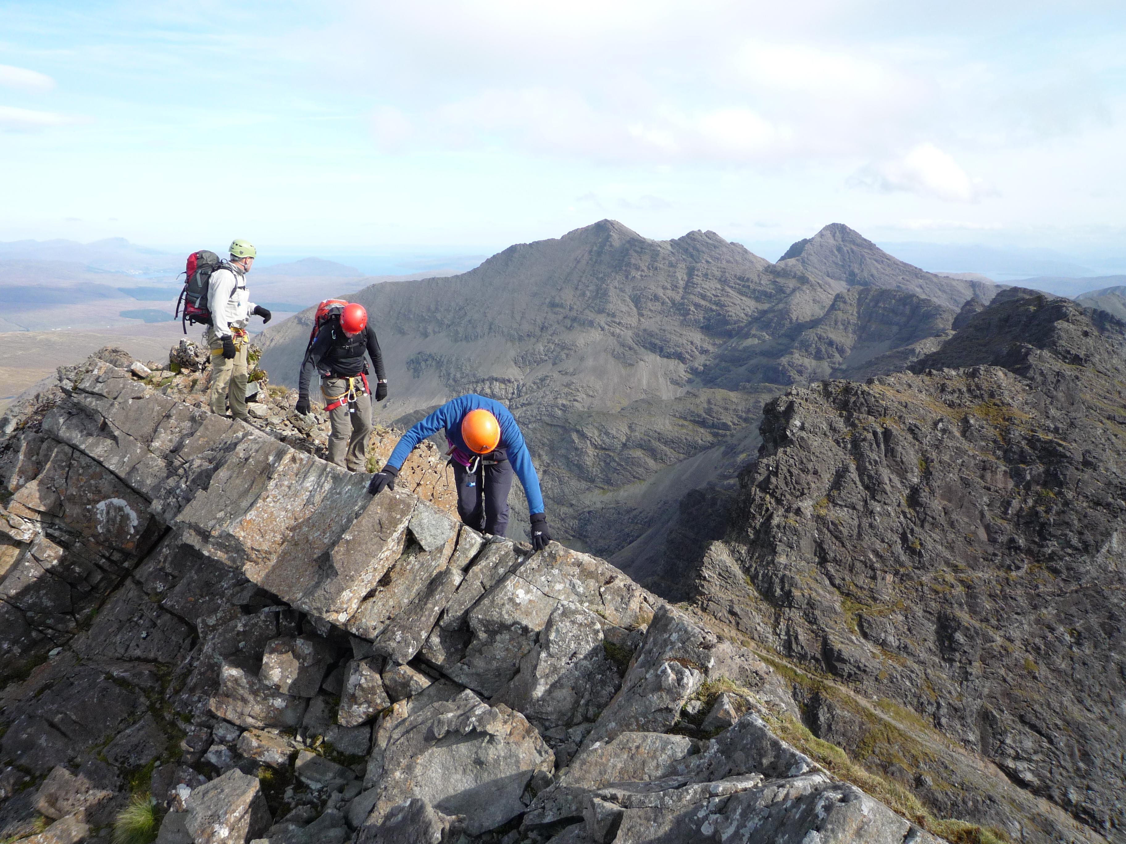
Cuillin Hills. From the old Norse kyöllen meaning ‘keel-shaped’, the Cuillins are Britain’s most spectacular mountains. Though the highest peak Sgurr Allasdarii is only 993m, the peaks are near-alpine with knife-edge ridges, jagged pinnacles, scree-filled gullies, and naked rock. A paradise for experienced mountaineers, there are still good low-level hikes: 1. Coire Lagan – from Glenbrittle campsite it is 6 miles round trip with a lochan and cliffs. 2. Loch Coruisk – remote loch ringed by the highest peaks of the Cuillin, accessible by boat from Eigol or a 5.5-mile hike from Kilmarie. There are two main bases for exploring the Cuillin – Sligachan or Glenbrittle.

I slept on the road above Uig, high above the north end of the Trotternish Peninsula for a gorgeous sunset. I took the ferry from Uig on Skye to Tarbert on North Harris (£37 for driver and car) for 2 ½ hours and started driving north towards Lewis.