
FORTH BRIDGE. A Unesco World Heritage Site, this is one of the finest engineering achievements of the 19th century. Completed in 1890, after 7 years of work, its three large cantilevers span 1447 meters and used 59,000 tons of steel, 8 million rivets, and the lives of 58 men.
FALKIRK
Falkirk Wheel. This fabulous piece of engineering is a boat lift that raises a tourist boat 39 meters up from one canal system to another short canal. Tours are only one hour long. Raising the boat is unbelievably efficient using only the power of 8 steam kettles for one lift.
The Kelpies. These two beautiful horsehead statues are located at the end of the canal. Constructed of stainless steel, they are lit up at night in a variety of colours. We parked here to see them at night and then tour them the next day.
STIRLING (pop 36,000)
Stirling is the crucial strategic point dividing the Lowlands from the Highlands. Scotland’s two most important independence battles were fought here: William Wallace’s victory over the English at Stirling Bridge in 1297, followed by Robert Bruce’s triumph at Bannockburn in 1314 – both established Scottish nationhood. The Old Town is crowned with the ramparts of its impressive castle.
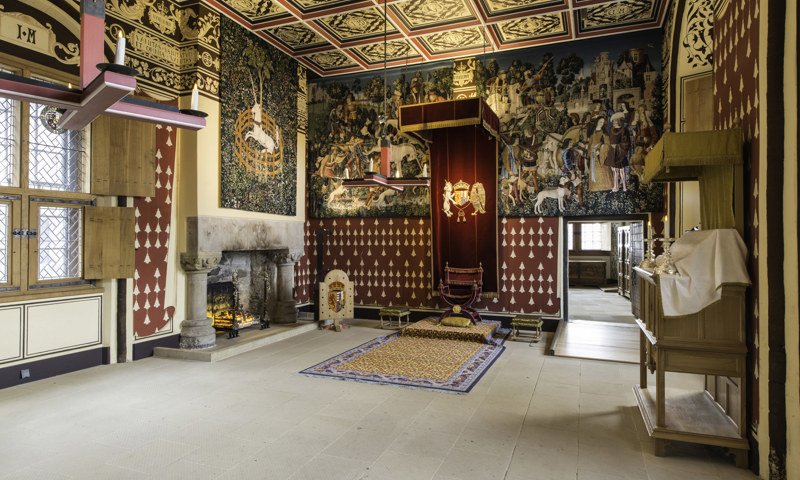
Stirling Castle. Hold Stirling and you control Scotland. This maxim has ensured that a fortress of some kind has existed here since prehistoric times. The current castle dates from the 14th to the 16th century, when it was a residence for the Stuart monarchs. The Royal Palace was constructed in the 16th century by French masons under the orders of James V. Notable are the Stirling Heads, painted oak roundels, and the Stirling tapestries depicting the hunting of a unicorn. The palace exterior is studded with beautiful sculptures.
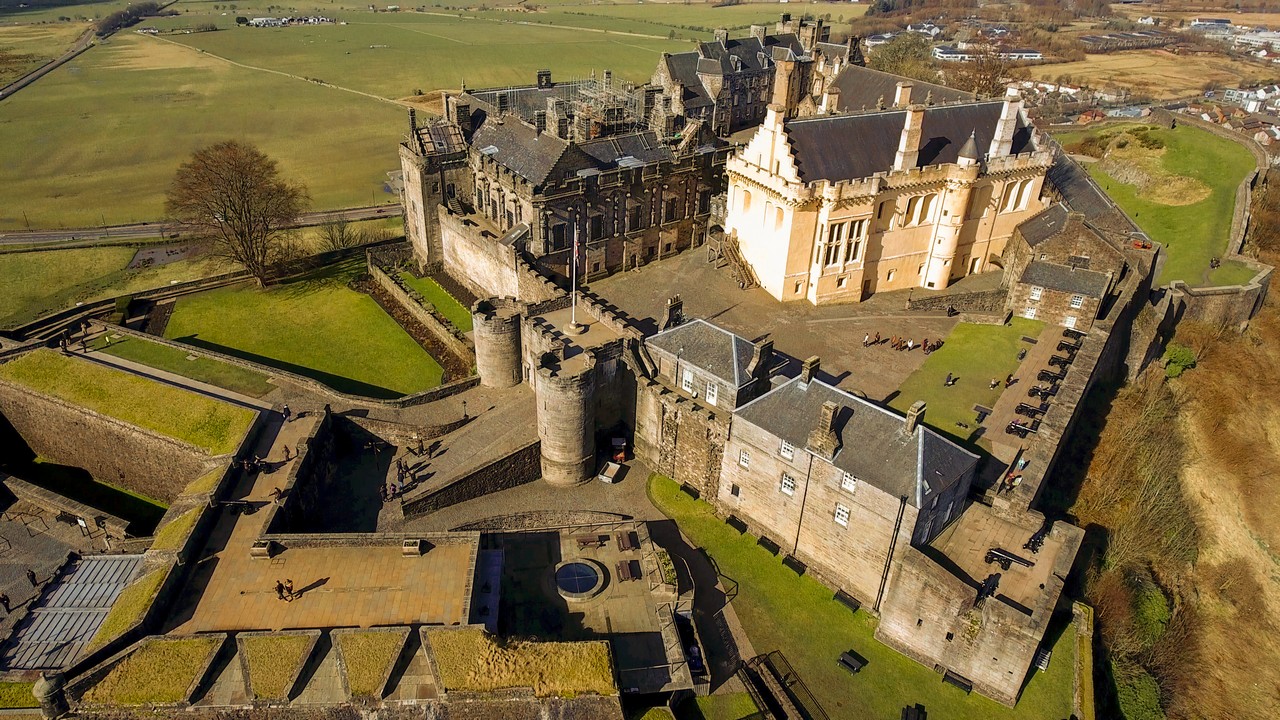
Other buildings are the Great Hall (James IV), the Royal Chapel (James VI), Great Kitchens, and the Argyll & Sutherland Highlanders Regimental Museum.
Great views of the surrounding countryside can be had from the ramparts.
National Wallace Monument. Perched high above Stirling is this Victorian 4-story tower commemorating Wallace, the hero of the bid for Scottish independence depicted in Braveheart. Climb up through galleries including the Hall of Heroes with Scottish luminaries, and Wallace’s 66-inch broadsword.

DRIVING TOUR of the FIFE COAST
Castle Campbell & Gardens. At Dollar, just NE of Stirling is the castle ruin set on a glen high above the town.
Dunfermline Abbey & Palace. In the city of Dunfermline, this abbey was founded by David I in the 12th century as a Benedictine monastery. Malcolm III married the exiled Saxon princess Margaret here and Robert the Bruce was buried here in 1329. What is left are the ruins of the three-tiered refectory and the old church adjoining the 19th-century church with Robert’s tomb. The palace was once the abbey guesthouse converted by James VI and his ill-fated son Charles I was born in 1600.

Below the abbey is Pittencrieff Park gifted to the city by a local boy made good, Andrew Carnegie (1835-1919) of US steel industry fame.
Going east along the north side of the Firth of Fife are the towns of Aberdour, Kirkcaldy (where we slept above the beach), Elle (sandy beaches and coastal footpaths), St Monan, Pittenweem, Anstruther, and Crail, all fishing villages on a very slow, winding road. This was certainly the long way to get to St Andrew’s.
ST ANDREWS (pop 17,000)
For a small town, St Andrews pulls its weight, first as a religious center and place of pilgrimage, then as Scotland’s oldest university, and then as the birthplace of golf.
History. It was founded by St Regulus who arrived from Greece in the 4th century, bringing with him the bones of St Andrew, Scotland’s patron saint. The town soon grew into a major pilgrimage center and later into the ecclesiastical capital of Scotland.
St Andrews Cathedral. Founded in 1160 and consecrated in 1318, it was pillaged in 1559 during the Reformation. All that’s left of Britain’s most magnificent medieval buildings are the ruined fragments of wall and arch. The museum has superb 17th and 18th grave slabs and the late 8th-century sarcophagus of St Andrew, Europe’s finest example of early medieval stone carving.

St Andrews Castle. The ruins sit on an evocative coastline.
St Andrews Golf Links. This is Europe’s largest golf facility with 7 different courses, all available for public play. The Old Course is the oldest and most famous golf course in the world. Golf has been played since the 15th century and in 1457, James II banned it as golf was interfering with his troop’s archery practice. The exclusive Royal & Ancient Golf Club does not own the course.
Booking to play the Old Course. Play for the subsequent year is opened in August the previous year. No bookings are taken for September or weekends. A ballot is held at 2 pm, two days before, but it is heavily subscribed. Singles are not eligible for the ballot and should queue at least by 5:30 on the day of play and may be slotted into available spots. A certified handicap (less than 24 for men and 36 for women) is an absolute requirement. Green fees are £175 in the summer (£145 when I was there in March).
Other courses are the Castle, New, Jubilee, Eden, Strathtyrum, and the 9-hole Balgove. The courses are right next to the west side of town. Nearby is the West Sands beach, made famous by the film Chariots of Fire.
It is possible to take guided tours or walk the perimeter footpaths of the course.
British Golf Museum. Across the road from the Old Course, this provides an overview of the game and the role of St Andrews. The huge collection has the oldest set of clubs from the late 17th century to modern clothing, equipment, and trophies. £7
DUNDEE (pop 147,000)
Scotland’s fourth-largest city lies in Angus, a fertile farming region stretching north to the Highland border. This was the Pictish heartland of the 7th and 8th centuries.
Dundee sits along the north shore of the Firth of Tay and during the 19th century, grew from a trading port to an industrial center with shipbuilding, whaling textile, and railway engineering. In the 19th and early 20th centuries, Dundee was one of the richest cities in Britain, but the textile and engineering industries disappeared leading to high unemployment and urban decay. Since the 1990s, it has reinvented itself as a tourist destination and center for banking, insurance, and high-tech. It has more university students (1 in 7, more than any other town in Europe except Heidelberg).
Verdant Works. Dundee firms owned and operated most of the jute mills in India and the city’s textile industry employed 45,000 people earning it the name ‘Juteopolis’. This marvellous museum explores the history of Dundee’s jute industry, from the raw material in India to the manufacture of sacking, rope, covered wagon covers carpet, and linoleum. Housed in a restored jute mill, it has all the original machinery in working order – a spry 79-year-old woman was my guide for this portion and she operated every machine showing every step in the process. An original James Watt steam engine was also operated. £8.75 reduced


The James Watt steam engine
McManus Galleries. Housed in a wonderful 1867 Victorian building, this great museum covers the history of the city and has an extensive art collection. Free
GLAMIS CASTLE
Just 12 miles north of Dundee, this has been a royal residence since 1372 the home of the Earls of Strathmore and Kinghorne and the home of the Queen Mother, Elizabeth Bowes-Lyon (1900-2002). Princess Margaret (1900-2002), the Queen’s sister was born here. Significantly altered in the 17th century, 10 of the 100 rooms including the royal apartments, are toured in a guided tour. The most interesting are several photos and letters of Elizabeth’s.
I am particularly tired of castles and this one was typical with a lavish dining room, lots of old paintings, and stag heads.
DUNNOTTAR CASTLE
South of Stonehaven, this castle occupies the most evocative position of any castle in England on a grassy promontory surrounded by 50m cliffs on all sides. The original fortress was built in the 9th century and is all ruins except for the chapel and drawing room restored in 1926. A few soldiers held out here for 8 months against Cromwell’s army.
Walk 20 minutes down a path, descend downstairs to water level and then climb up into the castle I slept here and was beat to the viewpoint by several photographers.
ABERDEEN (pop 195,000)
Since medieval times, Aberdeenshire and its northwestern neighbour Moray have been the richest and most fertile regions of the Highlands. It is famed for its many castles, Aberdeen Angus cattle, and the ‘granite city of Aberdeen.
Aberdeen is the powerhouse of the North Sea petroleum industry but is still a center of shipbuilding and trade.
Aberdeen Maritime Museum. This is centred on a 3-story replica of a North Sea oil production platform. Shipbuilding, whaling, and fishing are all covered and there are models of ships that you would never want to see again. Sleek, speedy Aberdeen clippers were the 19th-century shipyard specialty used by British merchants for the importation of wool and opium to Britain and on the return journey, emigrants to Australia. Free
Gordon Highlanders Museum. This military museum details the wars this group of soldiers has been involved in for centuries, with special emphasis on WW I when it sustained 29,000 casualties. £8
Instead of driving around the northeast coast of Moray, I turned west to the Cairngorms.
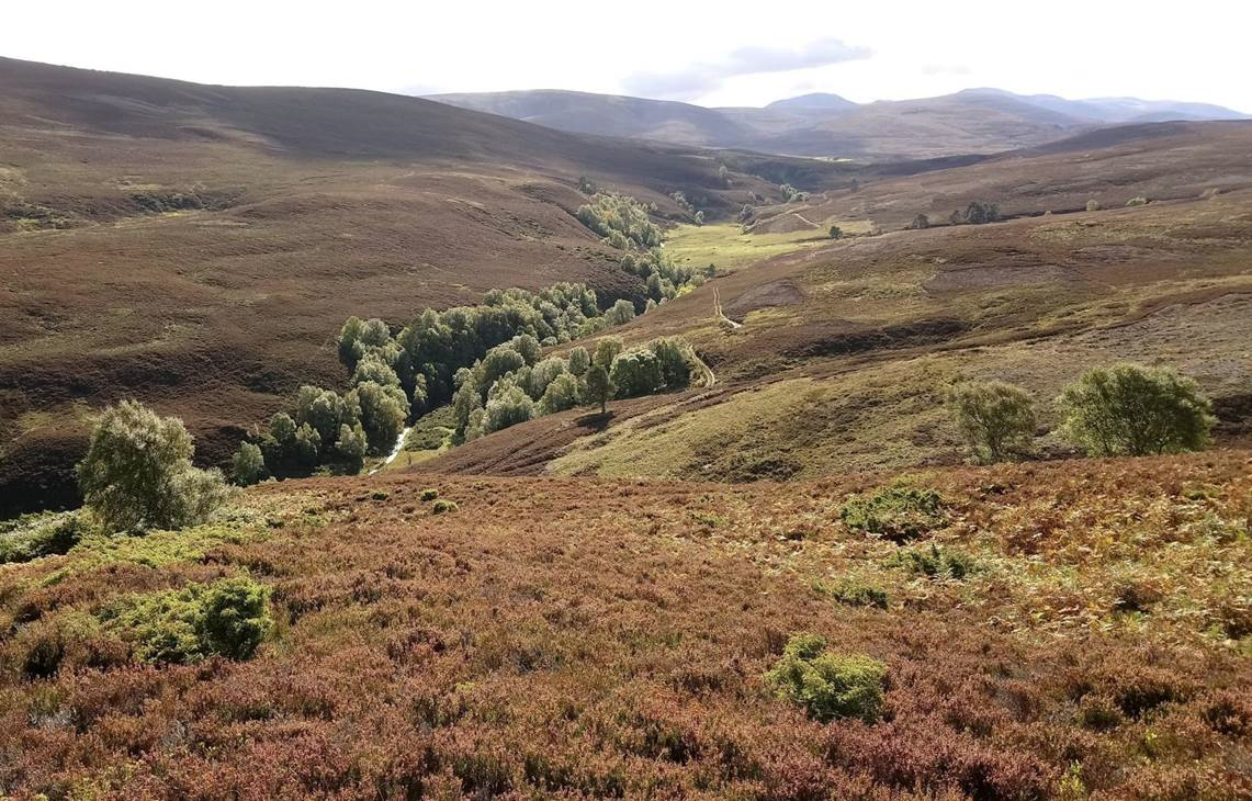
CAIRNGORMS NATIONAL PARK. The largest national park in the UK, it is more than twice the size of the Lake District. It also encompasses the highest landmass in Britain – a broad mountain plateau with an average altitude of over 1000m and including 5 of the highest summits in the UK. It is riven only by the deep valleys of the Lairig Ghru and Loch Avon. This mountain landscape of granite and heather has a sub-Arctic climate supporting alpine tundra vegetation and high-altitude birds. Lower down are open forests of native Scots pine. It is prime hill-walking territory. The Cairngorm Mountain Railway toes up to the edge of the plateau.
Balmoral Castle. Built by Queen Victoria in 1855 as a private residence for the royal family, it is built in the Scottish Baronial style of architecture. The ticket only sees one of the 69 rooms, the ballroom, but instead concentrates on the gardens and fruit trees. As this was late April, there was not much to see at the ten stops. The castle is open only from April through July when the vegetable garden is in full swing.
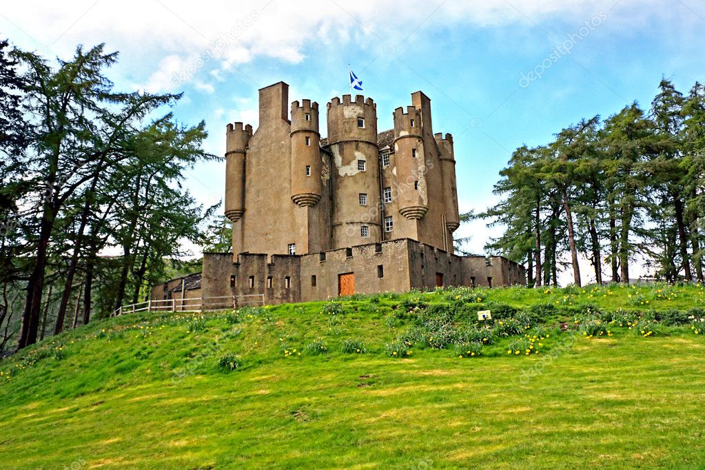
Braemar Castle. Just west of Balmoral is this castle dating from 1628 that controls vital passes. It was used as a government military garrison after the 1745 Jacobite Rebellion. It has now been taken over by the local community since 2007 – most of the original furniture was left. It is surrounded by walls and has 6 round turrets on the outside. The footprint is small but it is 4 stories high with all rooms part of the tour.
Just south is the village of Braemore well known for its highland games festival, the Braemar Gathering held in the first week of September runs continuously since 1817 and attended by monarchs since the late 1800s.
The drive from Braemar south goes through the spectacular countryside with no human or sheep presence. The scenery is only broken at the pass by a ski hill. The high hills covered by brown heather and riven with pretty glens were a delight. I turned west to Pitlochry, the narrowest two-lane road in the world. Pitlochry is a pretty town on the route to the highlands and can be busy in the summer. Just north is Blair Atoll. I drove around south of the castle to Old Blair and slept in a lovely forested parking area next to the creek with trails going everywhere.
Blair Castle. This is popular despite its exorbitant price (£29). The seat of the Duke of Atholl, head of the Murray clan and home to the Atholl Highlanders, the only private army in Britain. Parts date from 1269 but it was significantly renovated in the 18th and 19th centuries. t is a big white building set amongst forested slopes with 30 rooms open to the public. It shows upper-class highland life from the 16th century. Highlights include the drawing room, tapestry room, dining room, and ballroom with the usual paintings of rich folk, oak panelling, and hundreds of stag antlers.
NEWTONMORE
This town is on the west edge of Cairngorms NP on the way to Speyside and its hundreds of whisky distilleries.
Highland Folk Museum. This is an open-air museum spread along a 2+ km long road and path with a collection of mostly historical buildings and artifacts representing highland culture and lifestyle. Laid out like a farming township, it starts at the one end with a community of 17th-century thatched homes, sawmill, curling shed next to a pond, travellers tent, combined clock, and bicycle repairman, joinery, schoolhouse, 1850s house, 1930’s house, shinty clubhouse (this game like field hockey gave the name of shinny to hockey played outside on small rinks in Canada), store with a post office, sheep-shearing shed, smokehouse and a farm. It is quite enjoyable. Free
ELGIN (pop 23,000)
The capital of Moray for over 8 centuries, it has been an important town since medieval times. Moray is an ancient Celtic earldom and is famed for its mild climate and rich farmland. The barley fields supplied the raw material for Speyside whiskey, one of the main attractions for tourists.
Elgin Cathedral. The ruins are some of the most beautiful and evocative in Scotland. The octagonal chapter house is the finest in the country. Consecrated in 1224, it was burnt down in 1390. Climb the spiral staircase in both towers visiting galleries showcasing all the wonderful carving. At the top get panoramic views of the city and surroundings.


THE GREAT GLEN
This is a geological fault running arrow-straight across Scotland from Fort William to Inverness. The glaciers of the last ice age eroded a deep trough along the fault line, which is now filled by a series of lochs – Linnhe, Lochy, Oich, and Ness. General George Wade built a military road along the southern side of Loch Ness in the 18th century and in 1822, the various lochs were linked by the Caledonian Canal to create a cross-country waterway. The modern A82 road along the glen was completed in 1933.
INVERNESS (pop 62,000)
Inverness is the capital of the Highlands and the jumping-off point for the central, western and northern Highlands, the Moray Firth, and the Great Glen. The River Ness goes through Inverness at the north end of the Great Glen.
History. The city was founded by King David in the 12th century but few buildings of any age survive – most date from the completion of the canal in 1822.
Ness Islands. The main attraction in Inverness is the walk along the river to the Ness Islands. Start south of the castle. The islands have mature Scots pine, fir, beech, and sycamore and are linked to the banks of the river and each other by Victorian footbridges. Start on either side and return on the other.
When I walked it, there were several anglers in waist-deep water fishing for salmon. A fellow on the bank deplored the lack of fish and suggested it was due to seals that came upriver with the tide. I think it is due to overfishing, both commercial and recreational. No fish can be taken before June and only 2 are allowed per year.
Wynd Castle & Museum and Art Gallery. The castle is relatively modern and is the sheriff’s office but has good views of the older parts of town. Next door is the museum with good historical displays and the usual unappealing modern art. Free
Culloden Battlefield. 6 miles east of Inverness, is the site of the Battle of Culloden in 1746, the last battle ever fought on British soil that saw the defeat of Bonnie Prince Charlie and the end of the Jacobite dream when 1200 Highlanders were slaughtered by the government forces in a 68-minute rout. The Duke of Cumberland, son of the reigning King George II and leader of the Hanoverian army earned the name ‘Butcher’ for his brutal treatment of the defeated Jacobite forces. The battle marked the end of the old clan system and the horrors of the clearances soon followed.
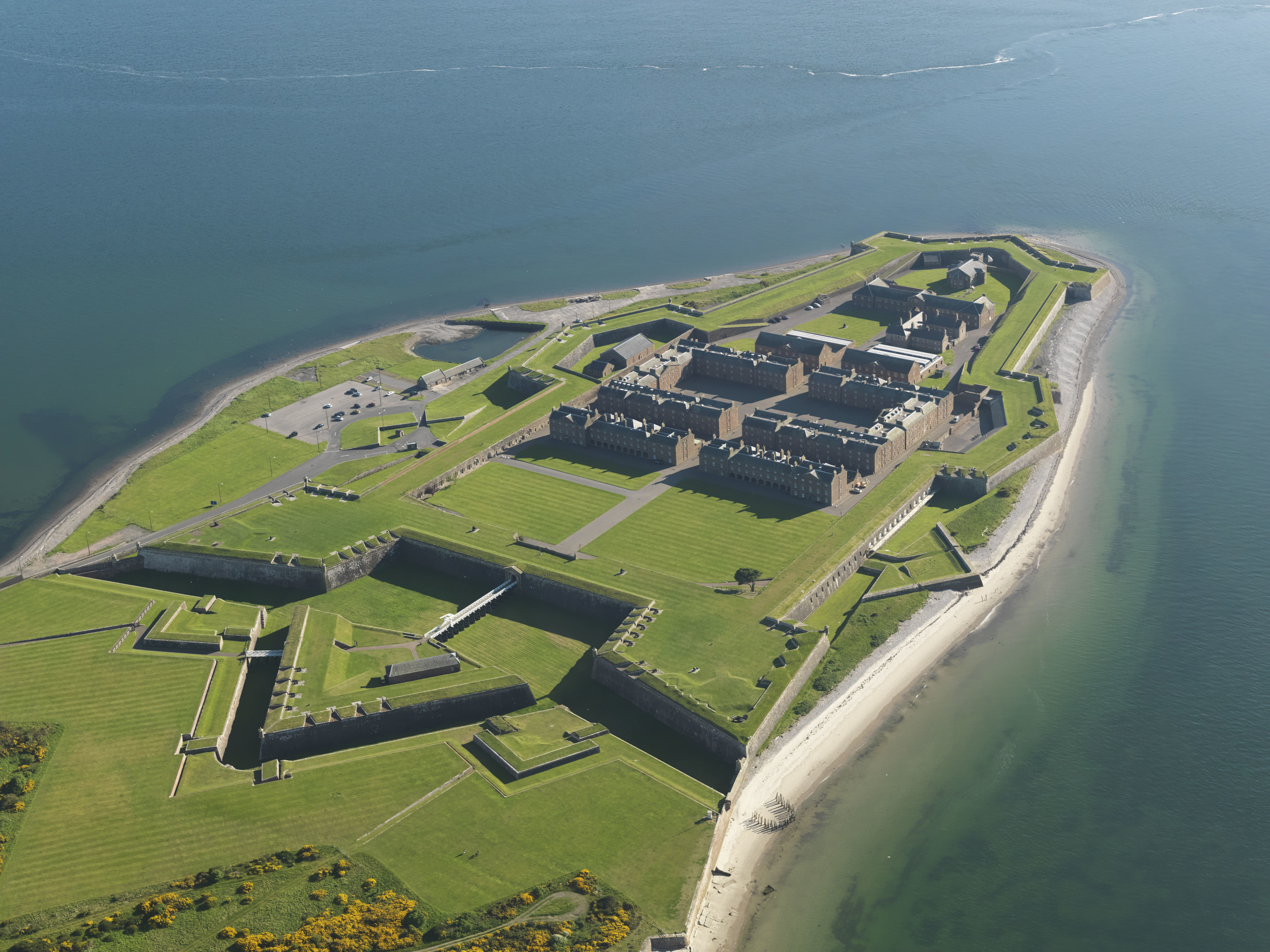
Fort George. It was established in 1748 in the aftermath of the Battle of Culloden as a base for George II’s army of occupation in the Highlands. By the time of its completion in 1789, it had cost the equivalent of £1 billion. Although it sits on the sea, it was built to withstand an attack from the land. It still functions as a military barracks. Several great videos tell the story and lots of places to visit. The mile-plus walk around the ramparts offers fine views out to sea and back to the Great Glen.
The fort is 11 miles NE of Inverness off the A96 on the way to Elgin. No public transport. £8.50
LOCH NESS. Long and narrow, it stretches for 23 miles between Inverness and Fort Augustus. The origins of the monster date to 1933 when a couple recounted the sighting of a creature rolling and plunging for a full minute. The story was taken up by the London press and sparked a flurry of sightings including the famous 1934 photograph taken by a supposedly reputable man, but since admitted to as a hoax. The rest is history. Sightings peaked in 1996-7 after the Hollywood movie Loch Ness was released, but reports have tailed off in recent years. A mini-industry of tour boats depart daily from Tomnahruich Bridge for the 3-6 hour cruise +/- coach tour.
Loch Ness Circuit. I drove the 70-mile complete circuit of the lake. Starting on the NE side, drive along the water and head inland at Forers over the single-track roads high above the lake. I walked down to the lovely Falls of Foyers that cascade down to a big pool. There are several nice walks around the falls. On top, pass a lovely loch and then descend to Fort Augustus.
Continue south by Loch Oich, turn west at Invergarry and then continue on A87 along the north side of Loch Garry to the famous Glengarry Viewpoint – through a quirk of perspective, the lochs to the west appear to form the map outline of Scotland.
Turn north on the A87 and A887 and return to Loch Ness at Invermoriston.
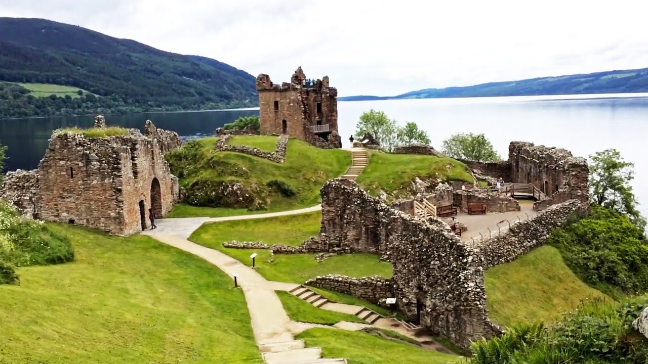
Urquhart Castle. On the shores of Loch Ness, this medieval castle was visited by St Columba in the 6th century, fought over several times, and finally abandoned in 1692. The ruins occupy an iconic setting and are a popular tourist stop, especially for Loch Ness tours.
EAST COAST
The twisting A9 road follows the coast with rolling farmland extending to the Sutherland Mountains the backdrop to the west. The last cheap gas is in Dingwall.
Dornoch (pop 1200). This attractive old market town is all elegant sandstone. The last witch to be executed in Scotland was boiled alive in hot tar here in 1722 and Madonna married Guy Ritchie here in 2000. Dornoch Beach stretches for miles. I camped on the beach next to hole 16 of the famous Royal Dornoch golf links, one of Scotland’s most famous.
Dunrobin Castle. A mile past Golspie, this castle dates to 1275 but most that you see was built between 1845-50. It was home to the first Duke of Sutherland notorious for some of the cruelest episodes of the Highland Clearances and is the Highland’s largest house. I stopped early in the morning and wandered out to the back balcony for nice views over the geometric gardens and fountains.
Lybster. The spectacular coastline goes through villages established on the shoreline when communities were evicted from the interior in the Clearances. Lybster is a purpose-built fishing village dating from 1810. In its heyday, it was Scotland’s third busiest port but now has only a few boats. I drove down to the picturesque harbour surrounded by grassy cliffs. It just happened that the weekly catch of crown crab (16 trays with 35kg each and a few lobsters) was being picked up by a seafood company.
Whaligoe Steps. At Ubster, 5 miles north of Lybster, don’t miss descending these spectacular stairs cut into the cliff down to a tiny natural harbour. A flat bench supported by a massive stone wall supports a ruined house and lots of evidence of past fishing glory. Turn off the highway opposite the sign ‘Cairn of Get’ and drive down the minor road to a parking area marked for locals only. A café is at the top of the stairs.
Grey Cairns of Camster. Dating from 4000 BC, these burial chambers are hidden in long, low mounds. The Long Cairn measures 60x21m and enters by crawling into the Round Cairn first. Turn off a mile east of Lybster on the A99 and drive 4 miles north.
John O’Groats. Almost the most northerly point on the British mainland, it is the endpoint for the 874-mile trek from Land’s End in Cornwall and a passenger ferry to Burwick in the Orkney.
Ferries to Orkney. I drove 5 miles west to Gills Bay to catch the Pentland Ferry to St Margaret’s Hope on South Ronaldsay Island on Orkney (£54). This is the cheapest way to get to Orkney. The Northlink Ferry from Scrabster (north of Thurso) goes to Stromness on Mainland Orkney and costs about £80. It does pass the Old Man of Hoy, a sea stack on the west coast of Hoy.