
Outer Hebrides and St Kilda April 27-May 2, 2018
The Western Isles are a 130-mile-long string of 119 islands off the NW coast of Scotland. The five main inhabited islands are Lewis and Harris (two parts of a single island although often described as if they are separate islands), North Uist, Benbecula, South Uist and Barra. The middle three are connected by road-bearing causeways.
The Outer Hebrides mark an important cultural divide – more than a third of the registered crofts are in the Outer Hebrides and no less than 60% are Gaelic speakers. The rigours of life in the black houses are within living memory. Religion still plays an important part in public and private life, especially in the Protestant north, where everything is closed on Sundays. The Roman Catholic South is a little more relaxed.
All listed ferry prices include the driver and are for a vehicle less than 6m long.
Hebridean Way. Over 252 km (156 miles) long, this long-distance walking route goes the length of the Outer Hebrides. It starts on Vetersay Island, at the south tip of the archipelago and crosses 10 islands, 6 causeways and 2 ferries to end at Stornoway on Lewis. It covers beaches, wildlife, mountains, past innumerable lochs and machair (machair is a Gaelic word meaning fertile plain and is formed by the sand from the beach, the remains of crushed-up shells being blown inland onto the naturally peaty soils). It is necessary to carry most of your food as cafes and shops are few and far between. A guidebook is essential as are a good waterproof jacket and trousers. Have bus schedules and taxi numbers. Don’t do from June to the end of August as the midges will drive you crazy.
The distance by islands is:
1. Vatersay and Barra: 24 km, moderate. Ferry 40 minutes from Barra.
2. Erisksay and South Uist: 57kms, easy/moderate.
3. Benbecula and Grimsay: 26kms, moderate.
4. North Uist and Berneray: 36kms, moderate. Ferry 1 hour on Sound of Harris.
5. Harris: 61kms, difficult.
6. Lewis: 48kms, moderate/difficult.
Tips for the Outer Hebrides
1. On Sunday EVERYTHING but a few businesses in Stornoway and the hotel in Tarbert are closed. Be prepared by buying all you need on Saturday. Even the golf course on Harris is closed on Sunday. This reflects the religious-based ‘blue laws’ on these very religious islands. When the ferry started to operate on Sundays, they were heavily picketed (even though it was a Sunday).
2. Get the Calmac Ferry Timetables with detailed departure/arrival times and costs for the 28 ferry routes servicing the outer and inner islands. In the summer (and it seems that all locals always make a reservation), it would be wise to book and pay for your ferry times at 0800 066 5000. There are a dizzying variety of ways to access the islands – from Ullapool, Uig, Mallaig and Oban. The long routes (Ullapool, Mallaig and Oban) take up to 6 hours, are usually only once per day and are expensive. Calmac is the only ferry company and has subsidized rates.
3. There is good free wi-fi service on some of the ferries and at the visitor centres in Stornoway and Tarbert.
4. The only grocery stores with a large selection and the best prices are in Stornoway and two-thirds down South Uist at a Co-op store. Buy gas before arriving on the Outer Hebrides at the Co-op service station at Broadford on Skye.
5. Buy a book on walks for the Outer Hebrides. I purchased ‘The Outer Hebrides – 40 Coast and Country Walks” (£6.99) which was more than adequate.
LEWIS
The north part of Lewis is dominated by the desolate expanse of the Black Moor, a vast, undulating peat bog with many lochans. The best scenery is the west coast from Barvas southwest to Mealista also with the best historic sites.
STORNOWAY (pop 5700)
This is the capital of the Outer Hebrides and the only real town in the whole archipelago. Set on a nice natural harbour, the town doesn’t win prizes for beauty or atmosphere. It also has the only businesses possibly open on Sunday.
Lews Castle. Across the harbour from Stornoway, it was built in 1840 by the Matheson family, then owners of Lewis, and gifted to the community in 1923. It holds the Museum of the Isles covering the history and island life. It also has 6 of the original Lewis chessmen (the others are in the British Museum). Free
The grounds host the Hebridean Celtic Festival, 4 days of folk, rock and Celtic music in the second half of July.
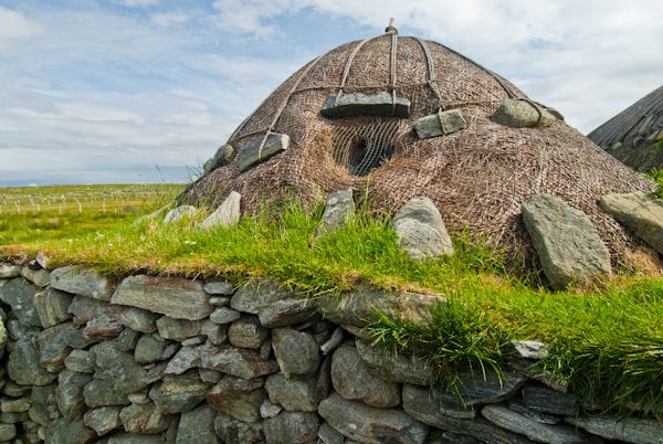
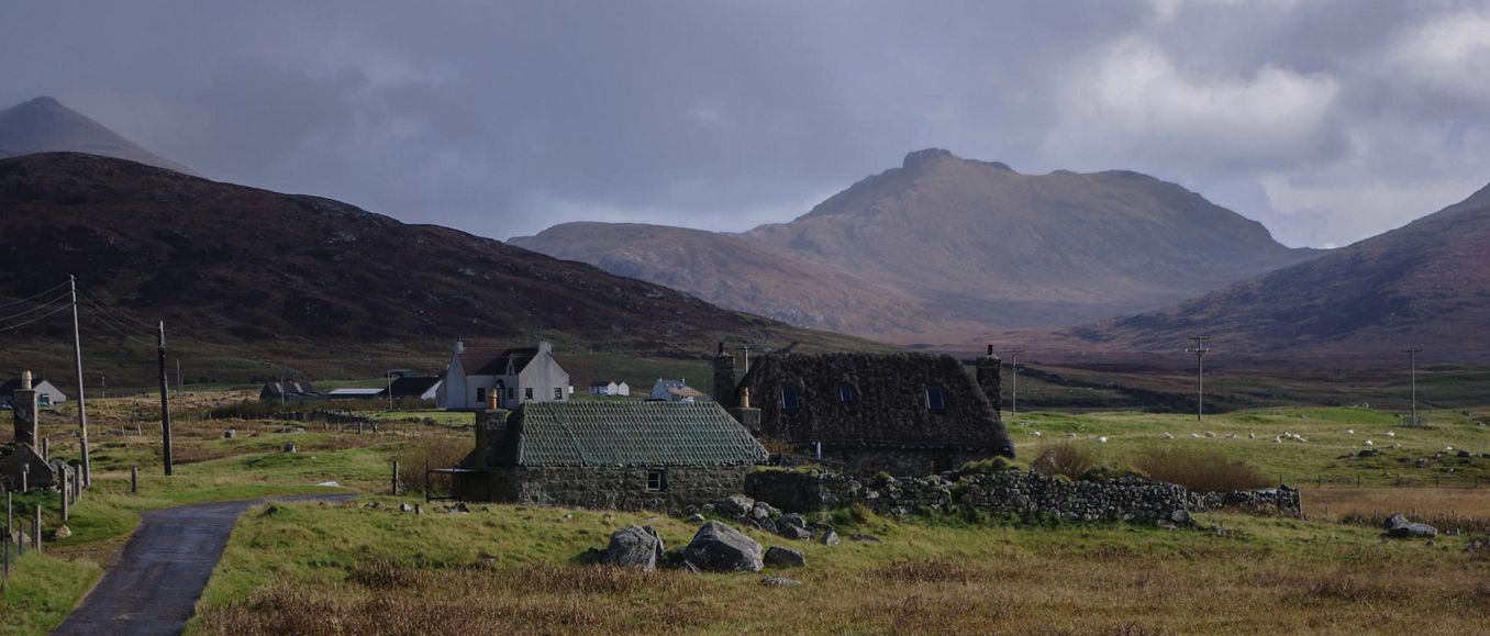
Arnol Black House. Black houses date from the Iron Age 2000 years ago, well before the Norse came. Similar dwellings are seen at L’Anse O’Meadow in Newfoundland and on Baffin Island Canada, and Jarshul in Shetland. The one here was built in 1885 and was still occupied until 1964. It is 3 miles west of Barvas.
They were remarkable for several reasons: they had a thick insulation layer between the two stone walls forming the perimeter. Animal quarters were inside the black house (added warmth and made the buildings cheaper to build). The roof was timbered (driftwood or even whale bone), then turf, covered by straw thatch and held down by rope netting. There was no chimney and the peat smoke had several advantages: killed bugs, tar coated the timbers preserving them, the smoke-filled straw made good fertilizer and fish and meat could be smoked. Apparently, the smoke did not decrease life expectancy as the two old women who lived in this black house lived to 89 and 102.
They are called black houses as later houses were limed and called ‘white houses’ and this name distinguished them.
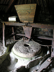
Norse Water Wheel and Kiln. About 5 miles south of Arnol (across from the large wind turbine) is this reconstructed horizontal water wheel. First described in China and probably common before the Vikings arrived, this one was called the Norse water wheel as they were especially common here after they arrived. Park at a large loch and cross the outlet stream, the water source for the wheel. It is about a 10-minute walk to the lower end of the stream that had a water race constructed above to divert water well above the wheel. The kiln and wheel are in lovely reconstructed black houses. The grain was dried in the kiln next door and fed from a large hopper into a hole in the centre of the grinding stones. The water turned horizontal paddles at the bottom of a metal post that turned the stones. The waterwheel was used by the entire community.
Dun Carloway. This 2000-year-old dry stone broch is a mile south of Carloway village. It has double walls with an internal staircase and stands to a height of 9m testifying to the engineering skills of its Iron Age architects.
Callanish Standing Stones. These are some of Scotland’s most atmospheric prehistoric sites. On the west coast and reached south of Arnol or by the other end of the loop road 15 miles from Stornoway, there are three sets of stones, all of the banded Lewisian gneiss (‘sparkling’ in Old Norse, composed of the minerals quartz, feldspar and hornblende). 5000 years old, they date from a warmer time when a pine/hazel/birch forest covered the ground and was subsequently replaced by peat bog (peat occurs when the plants don’t rot because they are waterlogged). They were discovered in 1857 when metres of peat were removed uncovering the stones.
Callanish I. 13 large stones are arranged around a 4.5m tall central monolith and 40 smaller stones radiate from the circle in the shape of a Celtic cross. 5 generations later, a chambered tomb was built in the center of the circle.
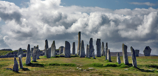
To reach Callanish II and III, return to the main road and go east. The circles are visible from the road.
Callanish II. Six standing and two fallen stones.
Callanish III. Eight standing stones and three fallen stones around four smaller stones in the shape of a cross.
HARRIS
To the south of Lewis and on the same island, Harris is the scenic jewel of the Outer Hebrides with rugged mountains, pristine beaches and barren rocky landscapes. The isthmus at Tarbert splits Harris in two. North Harris is dominated by mountains rising out of the peat moors to the south of Stornoway. Clisham (799m) is the highest point. South Harris is lower-lying, fringed by beautiful white-sand beaches in the west and a convoluted rocky coastline in the east.
Tarbert (pop 480). This harbour village is tucked into the narrow neck of land that links North and South Harris. It is the main ferry port from Uig on Skye and where I landed. The Hotel Hebrides is open on Sunday and is filled with rowdy islanders watching football in the bar.
I slept at a gravel pull-out on the side of the large inlet just north of Tarbert. As I was emailing to arrange a trip to St Kilda that was only available on a Monday, I hung around the visitor centre in Tarbert and mooched wi-fi from outside. Also in the lot was a couple from England with a VW van converted into a camper in England. The setup was much more custom than mine and much cheaper (£37,000), but I doubt as well designed.
Ascent of Clisham (An Cliseam). The highest mountain in the Outer Hebrides, this is a pathless 5.25km walk taking about 4-5 hours. Park at a lay-by on the A859 north of Tarbert a short distance south of the Maraig turnoff where the Abhainn Mharaig flows down from the mountain. Start at a path on the south side of the stream and ascend the straightforward route directly to the summit.
The Eagle Observatory. More than 20 pairs of golden eagles make their home in the mountains of North Harris and this is one of the best places to see them. Binoculars are necessary for the best views. Walk 5.25 km round trip.
Take the B887 between Tarbert and Huisinis park at an interpretation panel at Glenn Mhiabhaig near a bend in B887 and walk up the track up the glen. Soon the impressive rocky buttress of Sron Scourst comes to dominate the view up the glen. The North Harris Trust has built a hide. Sea eagles have broad wings and a large protruding head and beak; golden eagles have a less protruding head with a smaller beak and a longer tail. The walk can be extended up the glen to Loch Scourst or even farther to the heart of the North Harris mountains.
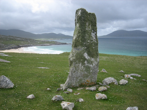
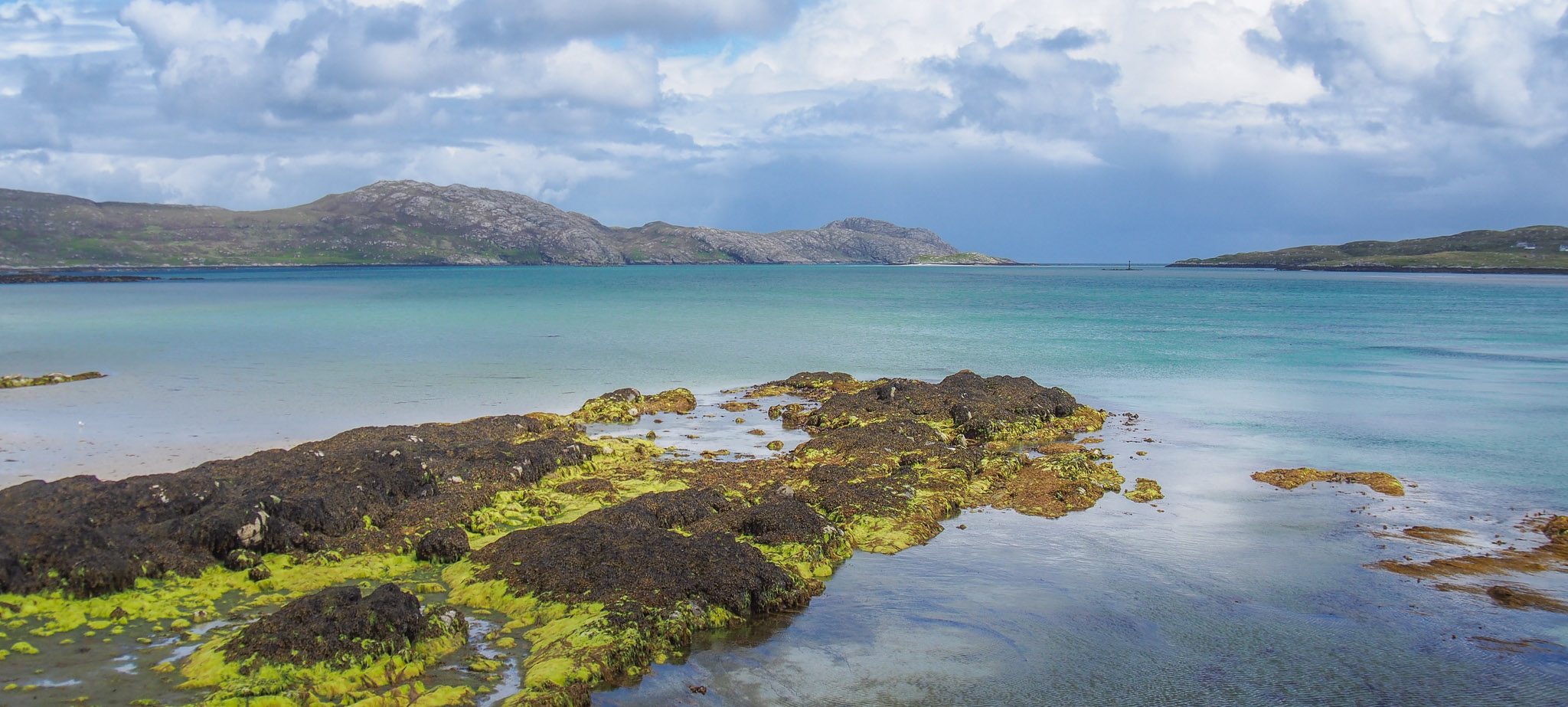
Macleod’s Stone & Traigh Iar. This 2.5km, 1-hour walk crosses a sandy beach and climbs up to a lovely standing stone on the west side of South Harris. Park at the south end of Traigh Iar (no sign), walk the entire length of the beach and climb up to the 3 meter-high stone. It stares directly out to Taransay Isle. Taransay became briefly famous as the base for the reality TV show Castaway but is uninhabited except for the annual Taransay fiddle festival. On the equinox, the sun sets exactly due west over St Kilda from the stone.
Then walk over the summit behind the stone and along the fence to a road that joins A859 and return to your car.
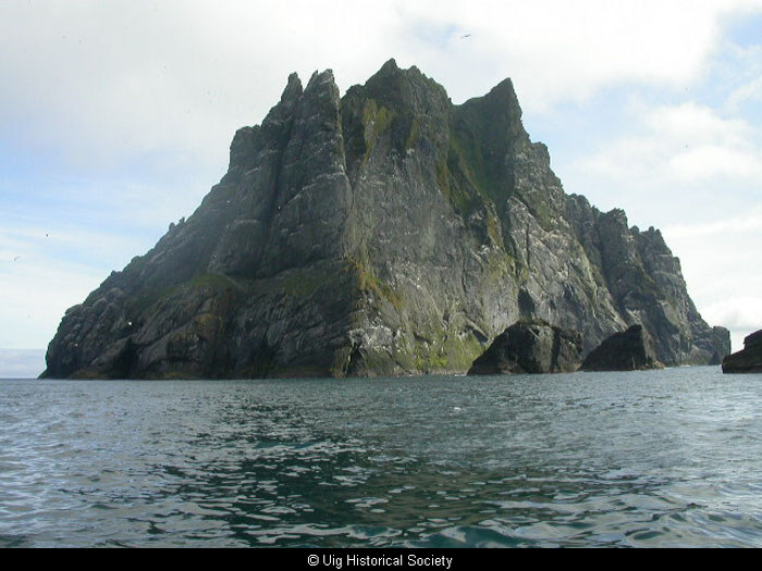
ST KILDA
The archipelago of St Kilda is in the Atlantic Ocean about 65km from Aird an Runair, the closest point on North Uist and 88 km from Leverburgh on Harris. The remnant of an ancient volcano comprises 4 islands: Hirta, Boreray, Soay, and Dun. In addition, there are 3 impressive sea stacks: Levenish guards the entrance to Village Bay on Hirta and Stac an Arnin and Stac Lee on the NNW and West of Boreray respectively. The isolated islands are all that remain above the sea of a large volcano thought to be active 60 million years ago. The rocks – granite, gabbro, and dolerite – have been scoured by glaciers, frost, rain, and coastal erosion with winds to 70mph and every 50 years or so, waves of more than 35m. On a clear day, Hirta and Boreray appear as dark silhouettes on the distant horizon from the Outer Hebrides. While the whole archipelago has been intensively exploited at one time or another, the focus of settlement has always been in Village Bay on Hirta.
It is renowned for its dramatic landscape and scenery, sea bird colonies, a subspecies of woodmouse and wren and 2 unique breeds of sheep (native sheep brought to the islands in ancient times and now a subspecies. Above all, it is a lament for a lost way of life and the desertion of a landscape. The last 36 permanent inhabitants were evacuated in 1930 for new homes on the Scottish mainland.
St Kilda was donated by the 5th Marquis of Bute to the National Trust in 1956 and designated a National Nature Reserve. The UK established a military radar tracking station on Hirta soon after; the unsightly base is still there today and it remains part of a missile testing range.
It was designated a World Heritage Site on both a natural and cultural basis (only 35 of these in the world and the only one in the UK) in 1986.
St Kilda is surrounded by impressive cliffs: those of Conachair are the tallest in Britain at 430m high while Stac an Armainn, at 190m, is the highest sea stack in Britain. It is the most important seabird breeding station in northwest Europe with about 1 million birds – there are the following nesting pairs: 23,000 common guillemots, 45,000 storm petrels, 60,000 northern gannets (the 2nd largest in the world), 68,000 fulmars and an astonishing 140,000 puffins.
There is evidence of people living on the Atlantic seaboard for 9000 years and on South Uist and Harris since 7000 BC. The Outer Hebrides were well occupied since 4000 BC and the first visitors came in the summer to hunt and fish on St Kilda in about 3800 BC. Village Bay has archaeological features dating back 2000 years. All the islands were used to graze sheep and as a base for fowling, the main industry.
In 1830, the villagers were assigned crofts with their own houses and land leading down to the water in a long narrow strip that was used for crops and grazing. The fowling areas were also divided up by family, while the ones on the stacks were common property. Most lived in black houses (see above) but starting in about 1860, they started building the stone houses seen today. They were not as efficient as the black houses as animals were separate and the chimneys lost a lot of heat.
1500 cleitean dot the islands (each family had several of their own) and are used for storing fish, birds, hay, peat or manure, for use over the winter months. Barley, oats, and potatoes were planted. Eggs provided abundant fresh food in summer and fowling was the largest employer and a community exercise – in the middle of March a select group went by boat and hunted them by night. Puffins were in June and July and young gannet in early August. For the young fulmar, the men were lowered by rope for several hundred feet, wrung the fulmar’s neck, and suspended them by a girth – they then plucked them, discarded the internal fat, and slated the carcasses for winter use. Feathers and oil were kept for export and helped pay the rent. Every person involved was covered in feathers for 10-20 days in August.
A big dyke separated summer grazing and land for crops and surrounds the village ending at cliffs on the water. Large enclosures were used to protect grass from cattle and used for winter feed. Cattle and sheep went to summer pastures in the high and did not return for months.
St Kilda is best known for its evacuation on August 29, 1930. The community had initially been largely self-reliant. A sizeable efflux followed the 1727-8 smallpox epidemic and in 1852, one-third emigrated to Australia, partly as a response to disputes within the Church of Scotland. There was a continual movement of young people in search of work. An individual croft was never likely to support parents with as many as 12 children who would in turn go on to have families of their own. A limit on the amount of available land, houses and jobs meant that emigration was inevitable.
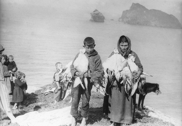
Returning from fowling

Hauling peat
Village Bay
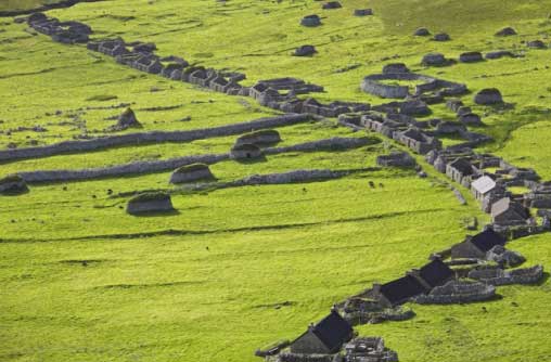
The main street

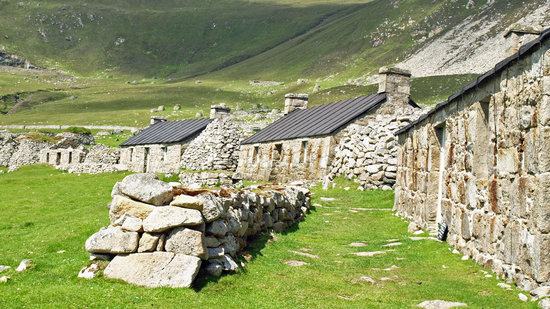
One of the 1500 cleits
The years after WWI were a tipping point when the number of able-bodied men declined to such an extent that handling a boat, cultivating fields, and harvesting the cliffs became difficult. Many infants died shortly after birth from tetanus. Remoteness from healthcare and burgeoning job opportunities elsewhere, the lure of far-off places, the opportunity for an easier life, and the difficulty in making a livelihood all contributed to the decline. In 1928, 37 people including only 7 able-bodied men were left and 36 were evacuated in 1930.
They left for the Hebrides, Glasgow, America, Canada, and Australia. By 1930, more St Kildians were living outside the islands than still resided there.
Tourists started coming in about 1800 but the first commercial vessel came in 1877, more after WW I, none during WW II, and then modern tourism started in about 1960. Originally, the locals showed their prodigious cliff-climbing skills. Tourists brought diseases and showed the locals that there was an easier life to be had.
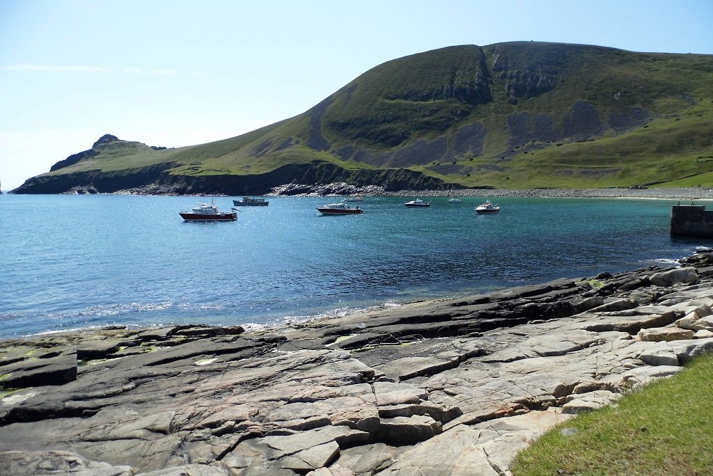
My Trip. There are several companies taking tours to the islands and mine was the first day of the season on April 30. The ones that operate from Leverburgh on South Harris are the cheapest. A company from Skye charges £260. I had originally contacted Sea Harris (£190), thought I had a trip but then there was no room. I slept overnight on the Leverburgh pier, a gorgeous spot on a lovely sunny evening with no wind. Sunset had great color.
The next morning, I met the owner of Kilda Cruises (£215) at the pier and he had one spot available. I vacillated about the price, but as the weather was so nice, I decided to bite the bullet and go. It would be my only opportunity to see this amazing place.
The trimaran left at 8 am and took 3 hours for the 80 km crossing. When you arrive at Village Bay, it is disappointing as the shore is a jumble of green flat-roofed modular buildings (the army base) and a large industrial-looking power plant.
First encountered on the far west of the town close to the shore are the Store (originally used to store feathers, bird oil and tweed with which the villagers paid their rent), and the Kirk (1820), the remnants of the original church with the schoolhouse attached. The Factor’s House (1860) was where the factor represented the laird and visited to collect the rent.
But you can see the rock walls and village behind. As food wasn’t supplied and I had brought none, I started walking towards the Gap, a low area in the eastern ridgeline. Go past all the stone enclosures used to grow winter silage and pass several cleists on the way. Cleists cover the hillsides and all open ground. Most people get this far as it gives you good views over to Boreray with Stac an Armin and Stac Lee.
I then turned north and walked the edge of the cliffs to the top of Conachair, at 376m, the highest mountain on St Kilda. From the summit, the cliffs dropped sheer to the ocean. A small cairn was on top, along with several of the local sheep. I walked down to the NW to the radar antennae and domes on Mullach Mor (361m) and then down the road to the village.
The views of the village are great from this angle showing all the fenced areas to the north that kept out the cattle and sheep and the curving Head Dyke surrounding the village to keep the sheep and cattle from the cultivated areas. There are the original black houses – with 2m walls, they sat end on to the street and after a gale that caused a lot of damage, they became byres and stores when the 16 improved stone houses were built – each with a chimney on either end and a slate in the chimney stating the last occupant of the house. The St Kilda Parliament which consisted of all able-bodied men met every day to decide the day’s activities. The graveyard behind the street is enclosed in a large oval of rock – most graves are simple and unmarked but since 1930, several St Kildans have been buried here. Houses 1-6 have been roofed and are now used by the National Trust of Scotland to house a museum and quarters for Trust employees. The House of the Fairies is behind the graveyard and was an underground store that dates from 500 BC to 300 AD. Calum Mor house is a legend that he built it in a day to prove his worth after he wasn’t chosen to go fowling on Boreray and may be over 1000 years old. Outside the dyke is Lady Grange’s house – she was exiled to Hirta for 8 years in the 1700s as her husband feared that she had heard too much Jacobite intrigue.
The boat departed St Kilda at 15:30 and we toured around the stacks and Boreray. With a turbulent sea between the islands, we had a great look at the gannet colony on top of Stac Lee and the cave the locals stayed in while fowling there. Their landing site on the stack was precarious at best.
Stac an Armin is the tallest sea stack in Britain at 190m. It also has a large colony of gannets. During the 1727-8 smallpox epidemic, the men fowling on Stac an Armin were not picked up and spent 6 months in a boursy on the north side of the stack. The cliffs of Boreray drop 143m sheer on the south side. There were two spots where boats could access Boreray, again precarious landings. We saw a colony of guillemots and puffins in the ocean on the east side. The return trip seemed overly long – coffee and cake were served.
Boreray

Boreray and Stac Lee
I slept again at the pier on Leverburgh. The weather on Tuesday was truly horrible with heavy rain and wind, quite a contrast from the day before. I took the ferry from Leverburgh to Berneray across the Sound of Harris (£17.5) and crossed the causeway to North Uist and Lochmaddy, the largest town on the island.
NORTH UIST
This island is half-drowned by lochs and is famed for its trout fishing. There are nice beaches on its north and west, and good bird watching, but less mountainous and wild than Harris. The road is a mix of single track with passing places, two-lane and causeway crossing the locks and ocean inlets.
On the drive south across the Uists, I passed about 20 cyclists, all out despite a horrendous day of rain and wind. There were even 3 walkers. I assume most were on the Hebridean Way.
LOCHMADDY. There is a small store here with limited supplies. A ferry goes from Lochmaddy to Uig on Skye (2 times per day, £37.20).
Taigh Chearsabhagh Museum and Arts Centre. This small, quaint museum has interesting accounts of the lives of several locals. The most significant occurrences in their lives occurred when electricity arrived in 1969 and the causeways were built. Many emphasized the role the rigid Free Church of Scotland played in their lives. Christmas was a pagan festival and not celebrated. Dances played a significant role in social life and most children had to leave the island for boarding schools on Skye and Inverness. The artifacts were things from my childhood.
The Plaiklelgarry Land Raid on the Balranald Estate in 1921 was in retaliation by men who had served in WWI and were promised land after the war for serving. The rebellion happened when the land transfer didn’t occur. The men were given 60 days in jail and eventually were given land.
SOUTH UIST
This is the second-largest island in the Outer Hebrides. The low-lying west coast is an almost unbroken stretch of white-sand beach and the interior has a multitude of lochans. The east coast is riven with 4 large sea lochs, hilly and remote.
South of Benbecula, cross from the predominately Protestant north half to the mostly Roman Catholic south, a religious transition marked by the granite pillar of Our Lady of the Isles is on the slopes of Ueval, the hill with the military radomes on its summit. Many roadside shrines commemorate the war dead.
A large Co-0p store has all the groceries one could need.
Kildonan Museum. This explores the life of crofters with B&W photographs and first-hand accounts of the harsh life.
Half a mile south is the birthplace of Flora MacDonald. She helped Bonnie Prince Charlie escape from South Uist disguised as Flora Macdonald’s female servant, Betty Burke to row the 24 miles over the sea to Skye in 1746 and then to France, was arrested, taken to London, imprisoned in the Tower and then pardoned. She married, emigrated to North Carolina where her husband fought for the British in the American Revolutionary War and was captured. She returned to Skye where her husband eventually joined her. The monument is a marvellous viewpoint.
Flora MacDonald Walking Route. 8kms, 2 hours. This easy walk starts at the Kildonan Museum, turns left onto the highway, visits the Flora MacDonald Memorial, returns to the road and then goes south to the next road going west and walks to the sea. Walk on the beach returning to the machair path at a gate where the shore starts to curve. Follow the path north to a good viewpoint and turn right heading inland to join a road that crosses a causeway and rejoins the highway to return to the museum.
Lochboisdale. The ferry leaves here at the south end of Uist to Mallaig departing at 7 am Monday-Friday and 06:20 Saturday-Sunday (£67.10). Mallaig is northwest of Fort William and avoided driving via Skye.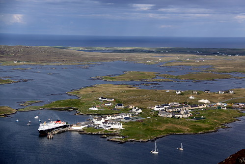
During the fierce storm, I took refuge behind a Catholic church, the biggest building around for a short snooze in the afternoon. I was woken up by the priest upset that his parishioners would be angry at someone ‘camping’ in their parking lot. I said I wasn’t camping but seeking relief from the wind but he wasn’t impressed. Ironically this is the only time I have been kicked out of any parking spot in 3 months – so much for ‘Christian’ goodwill – such hypocritical assholes.
By the evening, the storm had stopped and the sun came out. I slept on the south edge of the harbour and was at the ferry terminal at 6 am to buy my ticket to Mallaig as I hadn’t made a reservation. I arrived at the ferry at 6 to learn the ferry was going to Oban but not till 8:30. I must have been the only one who didn’t know as the rest of the passengers arrived well after 7.
Eriskay
BARRA (pop 1175)
Only 14 miles in circumference, there are beaches and rugged little hills. For a great view of the island, walk to the top of 383m Heaval, a mile NE of Castlebay, the largest village. A ferry runs from Castlebay to Oban (4¾ hours, £82.70) leaving at 07:55. On Wednesdays, it travels by Coll and Tiree Isles. I was tempted to do this but it got very expensive to stop at the two islands and see anything so it didn’t make much sense. I didn’t bother going to Barra (ferry from Eriskay 5 times/day, £13.60).
Kisimul Castle. This fortress was built by the MacNeil clan in the 11th century and requires a short boat trip to access it. It was restored in the 20th century by the 45th clan chief and gifted to Historic Scotland in 2000.