
ORKNEY
This archipelago of mostly flat, green-topped islands is one of the iconic places to visit in Great Britain. Its heritage dates to the Vikings whose influence is still strong today. It is best known for its ancient standing stones and prehistoric villages, sandy beaches, and picturesque coastal scenery. The Shetlands once had a birch alder scrub forest but no forest exists today.
The Pentland Firth is one of Europe’s most dangerous bodies of water and separates the northeast corner of Scotland for only 6 miles from the most southerly points of the Orkney.
SOUTH RONALDSAY ISLAND
The Pentland Ferry leaves from Gills Bay, 5 miles east of John O’Groats, and takes about an hour to arrive at St Margaret’s Hope on South Ronaldsay (£54 for one passenger). St Margaret’s Hope is named for the Maid of Norway who died here in 1290 on her way to marry Edward II of England, a strictly political affair as Margaret was only 7 at the time. I drove south to see that end of the island.
Stop at a good hilltop viewpoint that looks west over an ocean oil derrick to the Island of Hoy.
Tomb of the Eagles. On the south end is this Neolithic tomb where the remains of 340 people were interred 5000 years ago. Walk about a mile to the elaborate stone construction entered on a trolley. There is a fire pit, indoor well and plenty of seating. Pass the Banks Chambered Tomb, included in the entrance cost.
I drove down to Burwick, the small port where the John O’Groats ferry lands. Nearby is a closed church with an atmospheric graveyard and tombstones covered in moss.
To reach Mainland Orkney and the main city of Kirkwall drive north crossing 4 islands (South Ronaldsay, Burray, Glims Holm and Lamb Holm) joined by the four kilometers of the Churchill Causeways built on concrete blocks after a German U-boat sank the battleship HMS Royal Oak in 1939 with the loss of 833 lives. The causeways are on the eastern shore of Scapa Flow with several rusting wrecks of blockships. 84 ships of the German navy were interred here after WW I in 1919. The Germans ended up scuttling most of the ships in Scapa Flow.

Italian Chapel. This is all that remains of the POW camp that housed the Italian soldiers who worked on the Churchill Causeways. They built the chapel in their spare time from two Nissen huts, scrap metal, and considerable artistic skills. One returned in 1960 to restore the paintwork. It is on Lamb Holm.
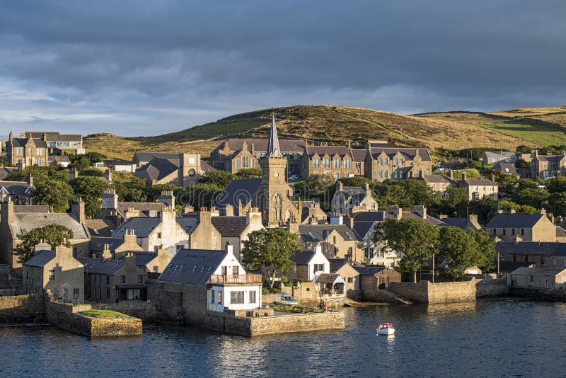
KIRKWALL (pop 7000)
This is Orkney’s main town and commercial center. Founded in the 11th century, the original part is one of the best examples of an ancient Norse town. It is set well back from the wide bay.
St Magnus Cathedral. Built in the early 12th century to commemorate St Magnus who was betrayed by his cousin, It is constructed of red sandstone and added onto over several centuries. The excellent written guide gives great insight into the wonderful interior. The pillars lean west giving an interesting slant. Large sandstone grave markers were moved from the nave and line the walls. Interpretations of the written inscriptions tell the seriousness of 16th and 17th-century bereavement. Most have skull and crossbones, hourglasses, and the shovel of the gravediggers embellishing them. The ship’s bell from the Royal Oak is here. The most interesting memorial is to Dr. John Rae, one of the best (and least appreciated) Arctic explorers of Canada. Over 5 voyages to the Arctic between 1844-54, he determined the fate of Sir John Franklin’s ill-fated last voyage and was the real discoverer of the Northwest Passage. His success was due to traveling with a very small band, hunting on the way, and wearing native clothing. Rae was born at Ophir near Stromness and his grave is at the back of the huge graveyard next to the wall. Lady Franklin never stopped cheering for her husband and denigrating Rae’s efforts.
Tours of the upper levels of the cathedral run on Tuesdays and Thursdays.
.jpg)
Orkney Museum. This excellent museum is an overview of Orkadian history and prehistory, including Pictish carvings and a great bit of Viking heritage. It is a maze of rooms and staircases, with the last showing 19th and 20th-century social history.
Orkney Wireless Museum. It has a great display of radios, domestic and military.
Bishops and Earls Palaces. Across from the cathedral, these ruins are best in the Earls Palace, once considered the finest example of French Renaissance architecture in Scotland, started in 1601 by Patrick Stewart and eventually bankrupted him, a scoundrel hanged for treason in 1615.

The Ba’. Every Christmas and New Year’s Day, Kirkwall holds a crazy ball game known as the ba’. Two enormous teams, the Uppies, and the Doonies, fight their way, no holds barred, through the streets, trying to get a leather ball to the other end of town. It can be violent especially when combined with alcohol and can last hours.
HEART OF NEOLITHIC ORKNEY
This group of World Heritage Sites has four sites, the most important Neolithic sites in Western Europe giving a graphic depiction of farming culture some 5,000 years ago. It is thought that this culture gave rise to the people who built Stonehenge, Avebury, Carnac in Brittany, France, and the Bend of the Boyne in Ireland.
Maes Howe. This burial tomb is entered through a low tunnel. Some of the stones making up the round structure are 3×9 meters in size weighing up to 4 tons and brought from several miles away. At head height, they slowly overlap each other producing a corbelled roof. There are large chambers on 3 sides. The tomb was entered by a boatload of Vikings in 1153 where they spent three days weathering out a blizzard. They threw out all the bones found inside and may have also removed treasure. At least 33 sets of runes were scratched into the stones inside both by men and women showing them to be a literate bunch. Showing that graffiti never changes, they wrote ‘Olaf was here’ and ‘Thorni bedded Helga’. They entered through the roof that was further destroyed in the 1870s when the first archaeologists examined the tomb. It was replaced by a farmer using double arches (now painted white) and has never been waterproof since. The setting sun of the winter solstice shines up the passageway for a few weeks.
Entrance is only by guided tour from the Maes Howe Visitor Center and involves a short bus ride and a 10-minute walk. £6

Standing Stones of Stenness. Four mighty stones remain of what was once a circle of 12 stones. The tallest is 5.7m tall. In the center is an altar of 4 smaller stones. They sit on a narrow strip of land separating the Harray and Stenness lochs and the site of a large settlement inhabited throughout the Neolithic period (3500-1800 BC). Nearby is the Watchman Stone and near it was the removed Odin Stone. A farmer was prevented from taking down a stone in 1814. Free
Barnhouse Neolithic Village. Alongside the Stenness Stones are the excavated remains of a village thought to be inhabited by the builders of Maes Howe. The houses are well preserved and similar to Skara Brae with their stone furnishings.
Ring of Brodgar. With only 36 of the original 60 stones still standing, it is still an imposing site as some of the stones are over 5m tall. In a circle 104m in diameter, they are surrounded by a ditch but no henge. There are also 13 Neolithic and Bronze Age mounds around it along with the Comet Stone. The ring is a mile north of Stenness. Free
Skara Brae. Situated on a sandy bay 8 miles north of Stromness is Northern Europe’s best-preserved Neolithic village. Even the stone furniture – beds, boxes, and dressers have survived 5000 years. It was hidden until 1850 when the waves of a severe storm eroded the sand and grass below the beach, exposing the houses underneath. The excellent museum has a reconstructed house. Then walk out to the site itself to see the village on walkways above the houses. There are earlier homes with the later houses built into the midden.
The joint ticket also gets you into Skaill House, a mansion built for the bishop in 1620 and now showing 1950s décor. £7.5

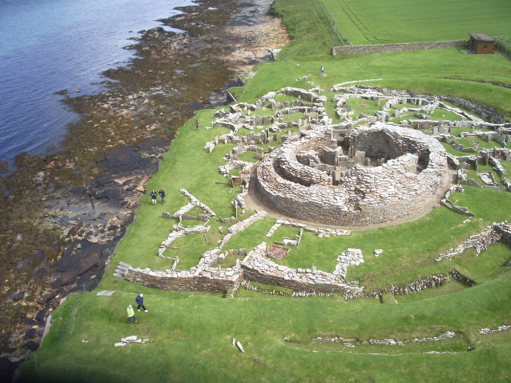
Broch of Gurness. This Iron Age settlement sits on the shore of Eynhallow Inlet 14km north of Kirkwall a few km off the A966. There is a massive broch (a dry stone defensive tower common all over Orkney) tower and a village defended by two rock-cut ditches and a rampart, clearly a place of power. £6
Brough of Birsay. 20km NW of Kirkwall off the A966, this small round island has prominent cliffs and can only be reached by a causeway at low tide. There is a Pict stone, a Viking settlement, a ruined medieval Romanesque church (a place of pilgrimage), and a lighthouse on the far shore. Unfortunately, the tide was in and couldn’t be reached – it looked like an awesome place for a hike. £5
STROMNESS (pop 1800)
On the SW corner of the Mainland, this was a busy staging port for ships avoiding the English Channel during European wars and was the start point for whalers and explorers to the Canadian Arctic. Drive into town on a very narrow one-lane main street (that has two-way traffic) between grey stone houses down to the waterfront. It has changed little since the 18th century. Leave town on the upper two-lane road.
Stromness Museum. It has maritime and natural history exhibits on whaling, the Hudson’s Bay Company, and the sunk German fleet. £5
The car ferry from Scrabster and the passenger ferry to Moaness on Hoy leave here. The car ferry to Lyness on Hoy departs from Houton, a few miles east of Stromness. Bookings are essential.
HOY (pop 400)
Orkney’s second-largest island has the lion’s share of the archipelago’s scenic beauty with massive sea cliffs on the west coast and peat moors cover the highest hills.
Old Man of Hoy. This 137m high sea stack juts from the ocean off the tip of an eroded headland. Walking to it passes most of Hoy’s best scenery. The easiest approach is from Rachwick Bay, a 5-mile road walk from Moaness Pier where the passenger ferry docks through the beautiful Rackwick Glen. Pass the 5000-year-old Dwarfie Stone, the only rock-cut tomb in Scotland.

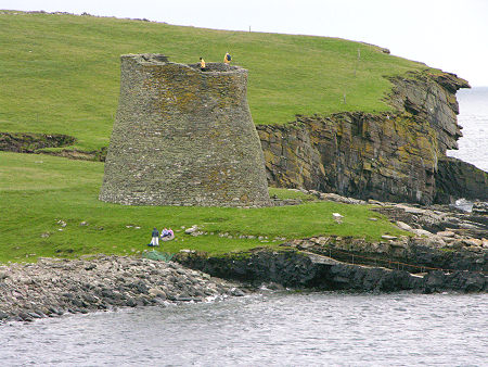
Hackness Martello Tower and Battery. On the SW corner of Hoy, this is a defensive installation built-in 1813-14 to protect British convoys during the Napoleonic Wars. The tower has views of Scapa Flow a naval anchorage in both world wars.
NORTHERN ISLANDS
The several islands north of the Mainland are a haven for birds, archaeological sites, and white-sand beaches. The landscapes are also flattish green farmland running down to the coastland. Orkney Ferries visits all of them. In the summer, get a pass (£41) from Orkney Ferries that covers only passenger service to all of them for one week.
Rousay (pop 200). It has several prehistoric sites. The ferry leaves from Tingwall. Visit the Midhowe Cairn, a burial tomb covered by a protective stone building.
Westray. The largest of the northern islands, it has rolling farmland, sandy beaches and great coastal walks.
Papa Westray. This tiny 4×1 mile island has a 5500-year-old Knap of Howar, the oldest domestic building in Europe.
I took the Northlink Ferry from Kirkwall to Lerwick in Shetland. It begins its journey in Aberdeen and stops at Kirkwall 3 times a week departing at 23:45 and arriving in Lerwick at 07:30 (£20.5/passenger one way). It then leaves Lerwick at 17:30 to return to Kirkwall at 23:00 on the same day giving you about 10 hours on Shetland. There are about 115 cabin beds, pod beds and reclining seats plus room for 600 passengers. The vessel, built-in 2002, is very attractive with a big restaurant and 3 lounges. I had a shower (£3 for a quick 5 minutes) on my way back to Kirkwall.
SHETLAND
Close enough to Norway geographically and historically, the Shetland are Britain’s most northerly outpost. Shetland was under Norse rule until 1469 when it was gifted to Scotland in exchange for a dowry for a Danish princess.
A Unesco Geopark, it has larger hills and cliffs than Orkney and many voes, large sea inlets that cut deeply into the islands. Offshore oil makes it a busy, well-healed place with excellent roads. Birdlife is spectacular.
LERWICK (pop 6800). Built on the herring trade and modernized on oil, Lerwick is Shetland’s only real town, home to ⅓ of the island’s population.
Shetland Museum. Another excellent museum, it has 5000 years of culture, geology, and fishing history with many full-scale boats. Free
Shetland Textile Museum.
I arrived, stowed my pack in left luggage in the ferry terminal, and started hitchhiking north. Trying to maximize my 10 hours, I got a little ambitious. After about 120 cars passed me (I learned later that it is not part of Shetland culture to pick up hitchhikers), I was finally given a ride by a friendly school teacher on a day off and going for a drive. He gave me an excellent tour and took me right to the ferry terminal at Toft where I took the 20-minute ferry to Ulsta on Yell Island. I soon realized I had bitten off too much, had other more important things to see, and reboarded (one fee covers all ferry traffic north of here). But I got to Yell.
SHETLAND HORSES. Small ponies have been in Shetland for at least 2000 years but archaeological evidence suggests that they have been in domestic use since the Bronze Age.
The smallest ponies thrived best in Shetland’s harsh winters when there was very little to eat, and this natural selection process has resulted in the famous diminutive size and hardiness of the species we see today. They eat seaweed along the shore and still do to augment their diet, not to ensure survival.
Ponies kept on the croft were used for pulling plows, carrying peat, and as a means of transport. When the 1800s Mines Act prohibited women and children from working underground, they changed to Shetland ponies who were small enough to work in the cramped conditions and strong enough to pull the carts. A Shetland pony can pull twice its won body weight, so they were in great demand, especially males over four years old.
There are many different colors, and sizes vary from miniature (34 inches in height or less when fully grown) to standard (up to 42 inches high).
Shetland has over 100 Shetland pony breeders and they are common by the roadsides. They are friendly but feeding is discouraged as it encourages bad behavior. The trade has gone through peaks and troughs but the annual sale in Lerwick, the oldest in the country, continues as an online sale where anyone in the world can bid at the Lerwick sale and help ensure the future of the Shetland pony and pony sale in Shetland. Visit www.shetlandponybreeders.com or email to see more information.

THE NORTH ISLES. Yell, Unst, and Fetlar are connected to each other by ferry free after your passage from Mainland to Yell. All are great for nature watching. Each island has an excellent brochure available on the ferry that lists every possible activity available.
YELL. (pop 1000). I crossed from Toft to Uista, realized that I didn’t really have the time to see anything, and returned on the same boat, but I at least stood on Yell. Visit the Old Haa Museum in Buravoe, the Lumbister Nature Reserve to see birds and otters, and several enticing looking walks.
UNST (pop 600). Scotland’s most northerly island, this is more rugged and prettier than Yell with bare hills. Visit the Hermaness Nature Reserve on a headland on the north end of the island for the 4.5km walk to see cliffs with birds and the rocks of Out Stack and Muckle Flugga with a Stevenson lighthouse. Beware of the great skuas that dive-bomb people when their nests are approached. Simply hold up your arm but they rarely make contact.
THE ZENITH OF IRON AGE SHETLAND
This Unesco World Heritage Site has 3 components:
Jarlshof Prehistoric and Norse Settlement. There are remains of 4000-year-old Bronze Age oval houses, an Iron Age broch, Viking longhouses (blackhouses), a medieval farmstead, and the ruins of a laird’s house built around 1600. The ancient sites were unearthed during a storm that washed away the sand covering everything.
I caught bus #6 going to the Sumburgh Airport from the Lerwick bus depot (£2.8, about every 2 hours) and got dropped off at the stop for the Sumbaugh Hotel. It takes an hour to drive the 23 km. It is a short walk to the site. After seeing Jarlshof, take the coastal path to Sumbaugh Head (30 minutes).
Old Scatness. An archaeology dig with a 300 BC broch.
Mousa. Cross to this small island by ferry to see an impressive, almost intact broch. I didn’t go to Scatness or Mousa because of time constraints and access problems.
Sumburgh Head. These impressive cliffs are a seabird mecca. Visit the lighthouse, foghorn, and radar installation for an extra charge.
I walked here from Jarlshof on the coastal path (30 minutes), returned down the road, and at the parking area continued over the next hill and down to the airport for great views.
The bus stops at the airport terminal.
FAIR ISLAND,
Take a ferry 2 hours and 40 minutes from Grutness near Sumburgh Airport (Tuesday, Thursday, and Saturday (last only in summer) or fly from Tingwall Airport to this island halfway between Orkney and Shetland. It is owned by the National Trust of Scotland. The island has a population of about 60, but in the mid-19th century was home to 380. There’s a shop, post office, primary school, and two churches.
The sea’s cliffs and coastline helped those fleeing from the Press Gang as they were able to hide with their contraband in Thief’s Hol, in the face of Malcolm Head. A small boat can pass through the tunnels penetrating Sheep Craig (443’). The Kim o’Skroo is a partially collapsed cave where the sea roars in via an 80 m-long subterranean passage.
There are 240 species of flowering plants, including juniper, rare elsewhere in Shetland. Seal pups can be seen in late summer at Easter and Wester Lodge. There’s a gannet colony at Dronger and puffins at Furse in the southeast. A bird observatory is especially interesting in the spring and fall.
History. There’s an Iron Age fort at Landberg and a large burnt mount at 712-foot Houlalie.
El Gran Grifon, flagship of the transport squadron of the Spanish Armada was wrecked in 1588. 300 sailors spent six weeks on the isle causing a hospitality headache for the then 17 households. The wreck was located in 1970 and divers recovered 38 guns. In 1984, a cross was dedicated to the 50 men who died.
Copper ore was mined in the 19th century. The north and south lighthouses were built by the Stevenson family in the 1890s and the south one was the last manned lighthouse in Scotland until 1998. Ward Hill has the remains of a wartime radar station on its summit. Fishing was the main source of income until the mid-20th century.
Now it has an active crofting culture with its knitting famous for its bright patterns. Knitwear was bartered with passing ships for spirits, and tobacco. They produced many garments for the Bruce expedition to the Antarctic in 1902/4.
The George Waterston Centre and Museum have artifacts.
After returning from Shetland on the ferry, I slept in the ferry lot and got up early to catch the 07:45 Pentland Ferry from St Margaret’s Hope back to Gills Bay on mainland Scotland.
FOULA
Foula: Britain’s most remote inhabited island
By Jamie Lafferty10th December 2021
Just 30 permanent residents live on Foula, which lays claim to being Britain’s most remote inhabited island and operates on a different calendar to the rest of the UK.
I learned several new words during my time in Shetland, the distant island chain drifting between Scotland and Norway. One of them was equinoctial. It means “of or relating to the equinox”. It is frequently used to describe equinoctial gales, which can feel relentless this far north when the seasons change in spring and autumn. In a place as exposed to the elements as Shetland, they can be definitive; on its most distant island of Foula, they can act as a sort of gatekeeper.
“Things are likely to get pretty entertaining,” said pilot Marshall Wishart as we boarded his BN-2B Islander to fly from the airport outside Shetland’s largest town, Lerwick, to the airstrip on Foula, 31 miles west. Our departure had already been delayed by the gales for many hours and for a time the forecast said that no flying would be possible for several days. Instead, however, half-an-hours’ notice was given to scramble to the airport and make a narrow weather window.
In a year dominated by domestic travel, Foula has perhaps been the most extreme option available to Brits. Sometimes referred to as Ultima Thule – Latin bywords for extremely remote destinations – it is said to be the most remote inhabited British island, reached by an unpredictable ferry or the frequently hectic 17-minute flight from the Shetland Mainland. Travel due west beyond it and there is nothing but the tumultuous North Atlantic until the east coast of Greenland.
On the day I flew, the equinoctial gales were strong enough to decapitate any white horses forming below. By that point in early October, the island’s ferry hadn’t sailed for a couple of weeks and wasn’t expected to try again for several more. This meant that the 30 or so permanent residents on the island depended wholly on the vagaries of light aircraft to bring them supplies. “It could be like this until the next equinox really,” said Sheila Gear, Foula resident of almost 60 years. “It’s only really late April or May that the wind finally stops. You have to be well-stocked, but you’re used to it if you live here.”
Hardy Foula sheep roam the island along with Shetland ponies (Credit: Jamie Lafferty)
Nonetheless, there is a limited amount of tourism, with just two guest houses – The Burns and Ristie – and a few camping sites providing accommodation. The majority of visitors are birders, drawn here by the tens of thousands of birds that make this blustery island home over summer. Otherwise, Foula offers few distractions for those not interested in the outdoors: there is no wi-fi, no pubs or bars, not even a shop to buy basic supplies. Visitors must bring everything with them.
To some people this is a surprise, but it is not the only one on Foula. Before making the long journey north, I asked some Shetlander friends what to expect. Not only had none of them been before, but they also didn’t even know anyone who had.
If outsiders know anything at all about the island it is likely to be that the residents still adhere to a version of the Julian calendar, having refused to change to the more modern Gregorian calendar in line with the rest of the country in 1752. They may also know that this was the last place in the United Kingdom to speak a Norse language, Norn. However, they may not be aware that the reason the language finally died out was because of a pandemic – not Covid-19, but smallpox, lethal waves of which washed over the island in the 18th Century, killing the majority of residents. When Foula was repopulated by English-speaking Shetlanders, Norn was lost.
Many of the words that endure today are names of seabirds. There are maalie (northern fulmars), tystie (guillemots), solan gos (gannets) and many more besides. Above them all, stands the great skua, or bonxie as it’s known locally. The huge, brown gull-like birds can be difficult creatures to love.
Even Gear, who has spent most of her life around them, finds their characteristics to be challenging, bordering on disgusting. “The real problem is that fishing boats discarding catch has created an artificially high population, beyond what the natural ecosystem can support,” she told me, between bonxie stories too upsetting to repeat here. “Where’s that going to end? It’s not sustainable.”
Located in the Shetland archipelago, Foula is the most isolated inhabited island in Britain (Credit: Jamie Lafferty)
The bonxie has no claws with which to kill its prey. It does, however, have the instincts of a predator, meaning it must use its barbed beak to pitilessly peck at its victims. Lambs are not safe, and even Shetland pony foals can be targeted. One night I saw a dead rabbit on the side of Foula’s only significant road; by morning, great skuas had disassembled it to something unrecognisable. The smaller Arctic skua (skooty aalin) is hardly a shrinking violet itself, but even it loses chicks to the bonxies. The island’s sturdy crows may have larger brains and a reputation for similarly callous behaviour, but they too give way to the piratical bonxies.
Yet even these screaming brigands can’t face Foula in winter, instead flying south to Africa to scavenge, rob and kill on a whole new continent before returning in spring. “For all I’ve said about them,” continued Gear, as though trying to strike a conciliatory tone, “we’re still really glad to see them come back each time. They’re part of life here and we’re fond of them, even if we’re not so fond of their behaviour.”
Birds aside, there is extraordinary beauty on Foula, too. The majority of the settlement is on the east side of the island, sheltering from the most violent of the North Atlantic’s furies. Disparate farms are surrounded by peat moss bogs that are dutifully patrolled by mismatching Foula sheep and Shetland ponies. While these scenes can look pretty, especially with the island’s satisfying ruddy hills in the background, the north coast is significantly more beautiful.
It’s there that Garda stands, a hulking three-pronged sea stack under constant attack from the ocean. The same is true nearby at the sensational Da Kame, the site of most of Foula’s birds’ nests. They have picked an exceptionally scenic spot; among the highest cliffs in Europe, this vast avian city looks especially dramatic at day’s end when the sun’s dying rays bounce off its mighty walls as waves crash in below.
The granite landscape does a lot better here than metal – salty gales eat at vehicles, meaning they rarely last more than a few years. Up and down the road, I saw abandoned cars stripped to skeletons by the elements. When I took a walk to the island’s graveyard, I found that the same wind had feasted on headstones, leaving most of them unreadable.
Foula was the last place in the UK to speak a Norse language
I explained to Gear that while I thoroughly enjoyed my time on her island, I had no notion to move there. I would wilt in the face of its challenges. “It can be a difficult place, especially in winter,” she replied with a slight chuckle. “There’s the darkness and the continual wind and rain. Just going outside can be very difficult, and yet you can grow to miss it. The first time I went abroad was to Madeira and I found myself missing the weather. It was ridiculous.”
A hard island for hard people and even harder birds. Magnus Holbourn, owner of the Burns cottage, summed it up on one especially windy morning. “This is not a place where humanity is in the ascendency,” he said. “It’s just clinging on.”
