
FRONTIER of the ROMAN EMPIRE – Hadrian’s Wall
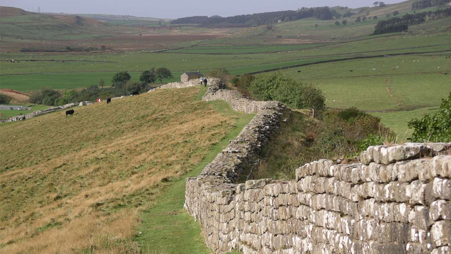
Julius Caesar first attempted to invade the British Isles in 54-55 BC but was unsuccessful. They tried a second time in about 50 AD and this time we’re able to subjugate the island. Eventually, they controlled the entire island extending even to the islands to the north of Scotland under Trajan (68-117 AD). Trajan’s adopted son Hadrian (The only emperor with a beard, he didn’t spend much time with his wife but preferred Antinous, a young man renowned for his beauty; he is known for building the Parthenon in Rome; he visited the north of England in 122) was emperor from 117-138 AD and consolidated power to an area running diagonally across the north of England and built Hadrian’s Wall between 120-128 to keep out the Picts. The defences across the north consisted of 6 forts along the west Solway coast (including Alauna at Maryport) and the wall that extended 73.5 miles (80 Roman miles) from Bowness on the Solway Firth in the west to the mouth of the Tyne at Wallsend on the east coast. Three legions (about 16,000 men) were in Britain and all took part at various times in the construction and patrolling of the wall.
Much of the western part of the wall was made from dirt, sod, and timber of which nothing presently exists, but most of the wall was substantial rock, 2 meters wide filled with rubble and dressed with stone on both sides. An elevated walkway was protected by a crenellated wall. Seventeen major forts were constructed along the wall; 80 mile castles were every Roman mile (.95 mile) and turrets were about every ⅓ mile. There was also a ditch and four bridges where rivers were crossed. The forts were in large rectangular enclosures with four gates.
Rome controlled Britain for 300 years but withdrew in about 400 AD when the Roman Empire was starting to fail. The entire area was Unesco listed in 1987 as Frontiers of the Roman Empire.
Over the centuries, most of the stone from the wall was removed and used to build local projects.
Hadrian’s Wall Path (www.nationaltrail.co.uk/hadrians-wall-path) is an 84-mile national trail that runs from Wallsend to Bowness.
Marysport Roman Museum. Settled by the Romans in the 2nd century, this was the most northerly extension of the Roman Empire. Named Alauna, the fort on the cliffs covered 6.5 acres and was garrisoned by up to 1000 soldiers from Austria, Italy, Provence France, Croatia, and North Africa, They were posted here for 3-4 years and occupied the area for 280 years. It was the military outpost on the west end of the Solway Coast to the west end of Hadrian’s Wall. The Roman Museum has 5 altars and remains of a temple.
CARLISLE (pop 75,000). On the frontier of Scotland and England, it has a stormy past on the frontlines of England’s defences for 1000 years: sacked by the Vikings, pillaged by the Scots, and plundered by the Border Reivers.
Carlisle Castle. Founded as a Celtic and Roman stronghold, it was added on by Normans and Henry II, Edward I, and Henry VIII. Mary, Queen of Scots was imprisoned here for 2 years in 1568 and it endured a month-long siege in the English Civil War by eating rats, mice, and castle dogs before finally surrendering in 1645. Both are Free with English Heritage.
Cumbria Museum of Military Life. Housed within the castle walls, it has an excellent collection of military memorabilia associated with the region’s regiments.
Birdoswald Roman Fort. This has the longest intact stretch of wall and the remains of a large fort. The east edge of the property drops vertically down to the River Irthing.

Roman Army Museum. On the site of the Carvoran Roman Fort, this excellent museum gives the most information about the construction of the wall and the soldiers who manned it with several 3D presentations. 6.7£
It is run by the same charity operating Vindolandia, a nearby fort that is the site of an active archaeological dig.
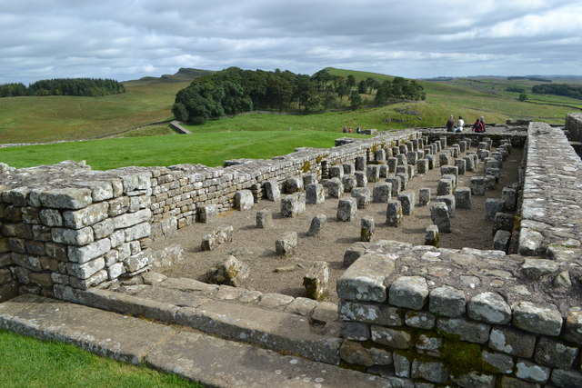
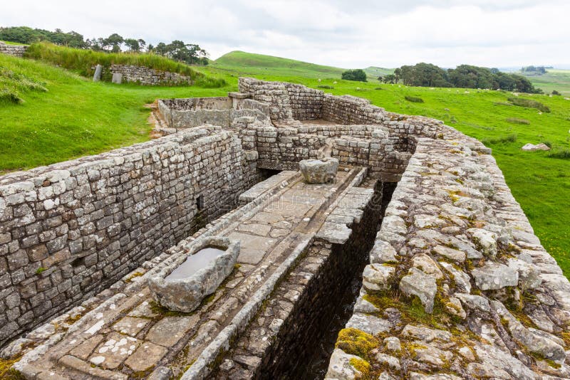
Housesteads Roman Fort. This is the best-preserved Roman fort. High on a ridge and covering 2 hectares, it has good views of Northumberland National Park and the snaking wall. It had a hospital, granaries, barrack blocks, and flushable toilets.
Chesters Roman Fort. Near the village of Chollerford, it includes part of a Roman bridge, four gatehouses, a bathhouse, and underfloor heating.