
The Earl Grey Pass is a 61km crossing of the Purcell Wilderness Conservancy between Toby and Hamill Creeks.
In 1807, David Thompson built Kootenay House for the North West Company near the mouth of Toby Creek. It was the first trading post in the region. From it, Thompson explored the Columbia River from source to mouth. Kinbasket, a chief of the Shuswap Indians, had led his people over this route in the early 1800s to their present home near Invermere. Then in 1866, the route over the Purcells to the head of Kootenay Lake was examined for a possible railway line but was judged unfeasible because a long tunnel through the divide was needed. During the late 1800s and early 1900s, this trail was an important access and supply route from the east, with cattle even being driven over it from Invermere.
During a visit to BC in 1908, Earl Grey (1904-1911), perhaps better known for his donation of football’s Grey Cup than as Governor-General, crossed the Purcell Mountains from Invermere to Argenta on Kootenay Lake by the trail up Toby Creek and down Hamill Creek. He was so impressed with the 10,000-foot peaks and extensive glaciers that he recommended the area for inclusion in a proposed national park. Not only that, he sited and paid for a public cabin near the start of the trail. The cabin was sturdily built and in good condition until the 80s. This trail and the high pass (then called Wells Pass) were later named in Earl Grey’s honour.
Public interest in the pass and trail was revived in 1972 by a group of local students who published the Earl Grey Pass Project.
NOTE TRAIL CLOSURE 2025
The West end of the trail was closed in 2025 due to the 2024 Argenta Creek wildfire. This caused a huge amount of deadfall and also affected one of the cable cars. A potential hazard was loose rolling debris (rocks/trees). The deadfall was so thick that one couldn’t walk 200 feet.
BC Parks manages the trail. [email protected] is regularly updated – the trail was closed on May 15, 2026. Contact Parks at [email protected] for the latest information. In the past, Parks has cleared all deadfall yearly.
Approaching from the east, the closure begins approximately 15 km from the pass (the Gas Creek bridge is about one km inside the closure).
The east side is better maintained until the outfitter lodge, as horseback riders also use the trail. There were over 100 deadfall to the pass, and the avalanche slide paths were overgrown with thimbleberries and alders.
Location: Purcell Wilderness Conservancy
Difficulty: D1
Elevation gain: 1525m (5000′)
Key elevations: West trail register 805m (2640′); Earl Grey Pass (44km) 2280m 7480′; East TH 1174m (3850′)
Distance: 61kms (38 miles)
Time: 3-5 days
Access: Easy
Season: early July to late September
Maps: 82K/2 Lardeau, 82K/7 Duncan Lake and 82K/8 Toby Creek
Drive:
East Access: From Invermere, drive through town towards Panorama Ski Resort. Zero odometer at the bridge where the Panorama road goes to the left. At 19km, where the forest road curves right and continues toward Jumbo Pass, look for a signed, overgrown left (south) spur. Leave vehicles near the horse corral, on a spur road west and below the trail sign.
West Access: From Kaslo: Zero odometer at junctions of Hwy 31A and 31N just west of and uphill from downtown.
0.0 Start north on Hwy 31N toward Lardeau and Duncan Lake.
28.4km Village of Lardeau.
34.5km Turn right onto Argenta Road. Starting east on Argenta Road Zero odometer.
36km Cross Duncan River Bridge. Pavement ends.
36.8km Junction. Right follow the Kootenay Lake shore curving south toward Argenta, Johnson’s Landing and Fry Creek Canyon. (left goes north up the Duncan River).
South to Fry Creek. Zero odometer
0.0 Start right to Argenta, Johnson’s Landing and Fry Creek Canyon
5.4km At the top of the hill, turn left (north) to Argenta and the Earl Grey Pass TH. Right goes south to Fry Creek Canyon.
The road goes through the town of Argenta. Continue beyond the Post Office, following signs to the corner in the logging road. With a high-clearance vehicle, drive the rough road 1km to the trailhead.
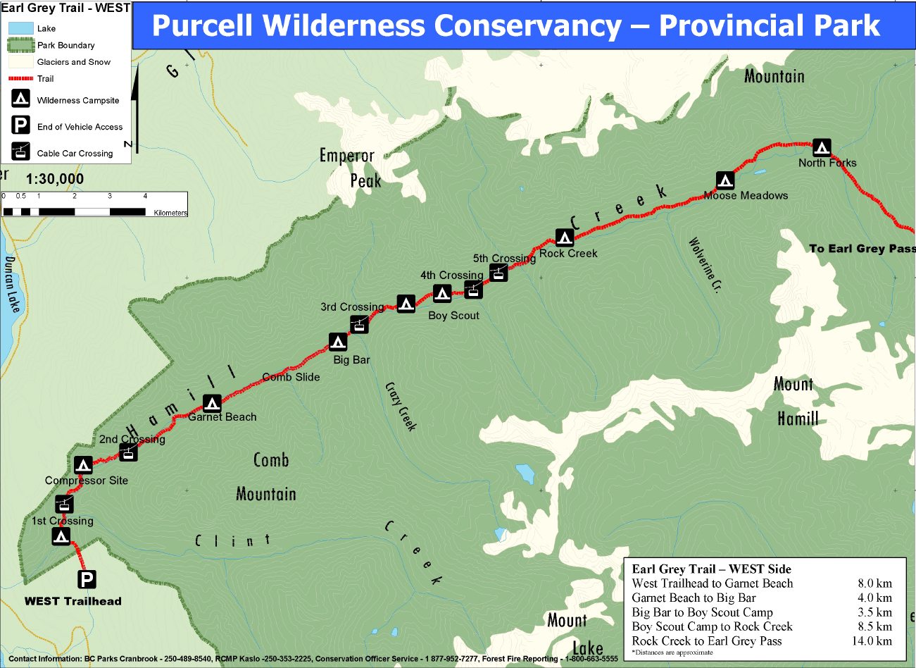
Trail: Follow the old road down to the trail which descends nearly 300m (985′) to Hamill Creek. At the bottom of the hill, the trail intersects the original wagon road that came up Hamill Creek. Take time to walk back along the moss-covered trail to the bridge site. Parts of it may still be standing. After returning to your pack, continue along the trail, crossing Clint Creek and making your way along several renewed cribbed sections. The cable car, installed prior to 1929, but refurbished since then, zooms across the creek. Remember to leave the cable car hanging free after use. There are six cable cars on the complete trail.
Soon after leaving the cable car, you reach the compressor site.
During the 1905-1906 period, a 10-drill Allis-Chalmers compressor was installed, driven by a large Pelton wheel which originally had a 35m (115′) head of water. High-pressure air was pumped 1200 m (3940′) up to the Argenta lead-silver mine on Lavina Ridge above Hamill Creek! All these materials were brought by wagon up the road/trail through the canyon, In the fall of 1907, the mine closed and soon after the lower canyon became impassable for wagons.
From the compressor site, the trail leads to McLaughlin’s Cabin, built in 1906, and the second cable car. From this point the trail follows the creek, often close to it, but sometimes well back amongst the huge cedars and hemlocks. Some old cabins exist as do remains of OFY trail maintenance camps of the early 1970s. Opportunities For Youth (OFY) was a federal government employment project that saw students working on the trail for one or two seasons. This was the first major work the trail had seen for decades. Numerous large slide paths are crossed; follow ribbons and previously cut alder and be careful at creek crossings. The BC Forest Service maintains the first 14.5 km of trail, the BC Parks maintained the remainder. Because the trail is classified as wilderness, it is not maintained as well as some trails in other provincial parks.
17km, start the climb slowly to the pass on a rougher trail.
32.5km, near the end of the valley, referred to as “north forks”, walk through an ancient cedar forest for half a day, and climb about 823m (2700′) in the final 8.5kms to Earl Grey Pass. The pass is underwhelming – below the tree line, straddling the ridge in a tiny notch with poor views. The panoramas are outstanding with chances of seeing mountain goats, elk and bears. Plan on camping at the toe of Toby Glacier below the pass for at least one night, if not two. There is a lot to wander around and see.
For encompassing views, climb Slate Peak from the pass. Fast strong day hikers can make it to Earl Grey Pass via the shorter eastern approach. Earl Grey Pass (44km) 2280m 7480′.
From the pass, one descends into the Toby Valley, passing Toby Falls. The trail follows the original route for the most part, slowly winding down the valley. Parts of the trail are used by guide outfitters and outdoor enthusiasts from the Invermere region. Often the trail is a muddy horse-tromped mess. Because of the frequent creek crossings on Hamill Creek, horses do not go on this side and the trail is better preserved. The predominately spruce forest on this drier eastern side is underwhelming. Unbridged tributaries and overgrown avalanche paths round out the adventure. Near the end of the trail a cabin is passed, built for Governor General Earl Grey. Soon after you reach Jim MacKay’s horse corral and the end of the trail.
Campsites & Milestones: There are few level spots to put up a tent. This is especially so from Rock Creek on the Hamill side over the pass and down Toby Creek. Try to reach and use the established campsites, most small with room for only two tents (keep groups down to 4 or fewer people). There are no outhouses. Leave no trace. There is no water at the pass, except perhaps from a seasonal creek 100m down the west side.
8km – Garnet Beach campsite. 910m (2980′). Creekside. Marked by a yellow blaze.
12km – Big Bar campsite. 966m (3170′). Under cedars and hemlocks.
15.5km – Boy Scout campsite. 1067m (3500′) 6 hours. Under huge cedars
23.5km – Rock Creek campsite. 1311m (4300′). Trees now are smaller spruce.
35km – north fork of Hamill Ck. Slick log crossing. Small tent site before this site. This is probably the last campsite before the pass, still 2.5-3 hours away. Last water also. Start 823m climb over 8.5 km to the pass. At 1750m, get the first good views of the trip.
44km – Earl Grey Pass – 2280m 7480′. The small grassy gap is below the tree line. Mt Hamill is SW, Mt Lady Grey, and Hyak Mt is ESE. Camping at the pass is not ideal.
Slate Peak – ascend the east side of the pass, reach a knob at 2482m (8140′), descend 43m and ascend to summit 2695m (8841′) in 1½ hours. NW is Blockhead (10,050′), and West of it is Cauldron (10,500′), backed by Quibble (10,200′) and further NW Ochre Peak (10,100′). On this side of the pass are the NE Toby Creek valley, SE is Toby Glacier, and South is Mt Toby (10,538′).
From the pass, it is 17km and about 6 hours to the east TH. After 45 minutes (2.5 km), an unsigned spur descends right to a campsite above Toby Falls.
1 hour from pass – Beside a cascade, room for 2 tents. North is Redtop Mt.
8km. McKay’s Falls, 3.5 hours below the pass.
8.2km. Creekside gravel flat campsite with room for several tents.
4.5 hours. Ford knee to thigh deep tributary.
15km. Earl Grey cabin NW at the forest edge.
16km Park boundary
17km East TH on Jumbo Pass FSR. 1174m (3850′)
Day hikes? In shoulder seasons, when alpine destinations are inaccessible, Hamill Creek is one of the best day hikes in the West Kootenay. From the west trailhead, the round-trip distance to Big Bar (the mother of West Kootenay cedar groves) is 24km.
Long day hike from east TH to Earl Grey Pass (34kms).
EARL GREY PASS GETS A FACELIFT
By Dave Quinn
May 23, 2018 KOOTENAY CULTURE MAGAZINE
In the early days of European settlement, exploration of the Kootenays was limited to the handful of established First Nations’ trails that unlocked the vast, untouched wilderness. These routes formed the lifelines of a fledgling colonization that would change the region forever. The Earl Grey Pass Trail, which traverses over a 2,256-metre pass in the Central Purcells to link East and West Kootenay, is one of the few historic routes not replaced by a road. It remains one of the region’s premier wilderness, adventure experiences.
The trail begins southwest of Invermere and travels 61 kilometres west to Argenta. Over the years, it’s been rerouted around avalanche debris and blowdown, boardwalks were built along steeper sections, and, cable cars were placed over dangerous creek crossings. And this summer, to celebrate Canada’s anniversary, Earl Grey is getting a special upgrade. Thanks to funding from the Canada 150 Program, Columbia Basin Trust and the Regional District, recent washouts will be repaired, as will damaged cable cars in Hammill Creek. Interpretive signage will also be installed to explain traditional Ktunaxa Nation knowledge of the route, along with other historical highlights.

Even with these upgrades, which will be done by BC Parks and the Kaslo and District Community Forest Society Youth Crew, the trail is a grind. It’s full of runoff debris, head-high stinging nettle, and other surprises, so hikers who complete it earn substantial backcountry cred. It’s hard to imagine one cow, let alone a whole herd, travelling this trail and arriving intact at the other end. But that’s exactly what used to happen. Here’s a look at the story behind of one of the Kootenays’ most significant byways.
The Earl Grey Pass Trail began as a well-worn, hoof-and-claw path that showed the way to Ktunaxa hunters and traders. They in turn guided early miners across the Purcells, and the trail was expanded to allow horse travel in the Kootenay mining boom of the late 1800s. The route was known as the “Beef Trail” in the early days, as cattle were driven across from the ranches in the east to feed hungry miners in the west.
The region saw its first brush with fame in 1908 when Albert Henry George Grey, Canada’s ninth Governor General and the fourth Earl of Grey, visited and fell in love with it. That summer he travelled on horseback up Toby Creek from Invermere, through the ancient forests of Hammill Creek, to the mining settlement of Argenta.
So stoked was he with the forests, game, glaciers, and towering peaks of the Central Purcells, he had a family cabin built on Toby Creek a year later. Governor General Grey even wrote to then Premier of British Columbia, Richard McBride, making the case to set the region aside as a national park. The proposal did not bear fruit, however, and for the next five decades the still remote, Central Purcells were visited by climbers, prospectors, hunters and trappers. That changed when Toby Creek’s Mineral King Mine, first staked in 1898, was substantially developed in the 1950s.
This development, along with an explosion of forestry roads into the heart of the Purcells, prompted the Invermere Rod and Gun Club along with Argenta hippies to push for the protection of the remaining wilderness. In the early 70s, Federal funds were received via the Opportunities for Youth project to reroute the trail past burned-over areas. Invermere resident Pat Bavin lead the project in 1972. “In July of that year, we took a 10-horse, pack train of dried food up to the Toby Glacier outwash, and worked for 10 days on, out for four, all the way through to September,” he says. “Restoring the trail…was quite a challenge since it was totally overgrown with numerous avalanche debris zones.”
Bavin’s crew also mapped the headwaters of Toby Creek and created a master plan for a future, alpine-protected area.
Finally, in 1974, after a first-of-its-kind, grassroots conservation effort that saw hunters and trappers united with hippy tree-huggers, an Order-in-Council literally stopped bulldozers in their tracks with the creation of the Purcell Wilderness Conservancy. The Earl Grey Pass Trail traverses its northern limits.
Hikers will still find Earl Grey’s family cabin perched at the edge of a massive avalanche path, looking west past the dramatic Pharoah Peaks to the headwaters of Toby Creek. The intervening century has left the log structure in a ruinous state, although, miraculously, much of the roof still remains. A stone hearth welcomes. Bits of beds and furniture are still visible through a mountain of packrat middens. Behind it lies the remains of an outhouse and what must have been either a log barn or servant’s quarters, or both. The essence and the romance of the wild Purcells are still strong here, carried on by the very sense of discovery and awe by the trail’s early explorers.
For more information about the Earl Grey Pass Trail, log on to the provincial government park’s website.
Dave Quinn
Born in Cranbrook, British Columbia, Dave is a wildlife biologist, educator, wilderness guide, writer and photographer whose work is driven by his passion for wilderness and wild spaces. His work with endangered mountain caribou and badgers, threatened fisher and grizzly, as well as lynx and other species has helped shape his understanding of the Kootenay backcountry and its wildlife, and help shape his efforts to protect what remains. His writing and photography has helped fill the pages of publications such as British Columbia Magazine, Westworld, the Financial Post, Backcountry, Adventure Kayak, as well as the Patagonia and MEC catalogs.
