
Angola March 9-10 & 14-28, 2017
TRAVEL TIPS
1. Angola is a black market money country. Therefore never use an ATM or credit card as it will attract the official rate 1US$ = 175AOA whereas the black market rate was 660, ie. 5X.
2. If traveling overland, and moving north to south, make sure you have a double entry visa for Angola. Crossing from the Republic of Congo to the DRC via Kinshasa is almost impossible because of all the bureaucracy. Going via Cabinda, Angola is the only reasonable way. The first entry is for Congo to Cabinda and the second is for DRC to Angola. The visa costs US$300, twice what a single entry visa costs, but worth it.
3. Have scanned copies of passport main pages and visas on separate pieces of paper. Photocopies are not generally accepted.
4. Consider rabies vaccine. We have hardly seen any dogs since Morocco, but Angola supposedly has lots – and an exceptionally high endemic rate of rabies in the dog population. There are a reported 500 deaths/year from rabies in Luanda alone, mostly because of the rarity of rabies immune globulin. The vaccine is exceedingly expensive in Canada at $C600 (3 doses at $C200 each), but as rabies is 100% deadly once established, we all need to access our risk tolerance. I elected to not have the vaccine. In fact, we have seen quite a few dogs but no worrisome interactions.
Why Go?
Oil, Diamonds & Unspoilt Coastline, it is scarred painfully by years of debilitating warfare and practically untouched by foreign visitors since the early 1970s. The country remains remote but with a unique geography and culture.
Despite advancements in infrastructure and a dramatically improved security situation, travel in Angola remains the preserve of adventurers or those on flexible budgets. But with the transport network gradually recovering and wildlife being shipped in to repopulate decimated national parks, the signs of recovery are more than just a mirage.
For outsiders, the attractions are manifold.
Capital and largest city. Luanda 8°50′S 13°20′E
Language. Official Portuguese.
Independence from Portugal 11 November 1975
Area. Total 1,246,700 km2 (23rd). 2x Texas or 5x Britain. Dimensions. Atlantic coastline 1,650kms, extends inland for 960km, ⅓ of the way across Africa.
Population. 2014 census 25,789,024. Density. 20.69/km2 (199th)
Life expectancy. 41.7 years
GDP (PPP). 2016 estimate Total $194.055 billion[2] (64th). Per capita $7,501 (107th)
MONEY – Currency new kwanza (AOA).
Because of the black market money, never withdraw money from an ATM using a debit or credit card, and do not use a credit card to buy anything including hotel rooms. You will be paying a 400% premium.
VISAS. Almost all nationalities must get a visa prior to arrival.
Congo/Cabinda, Angola border.
It took about an hour to get our Congo exit stamp and then hours to enter at Cabinda. We all had to go into an office to fill out a form where it was stressed that they all be filled in identically. This included our itinerary through the DRC and Angola proper.
Over the years, they have required photocopies of our passport page and the visa – initially, black and white was ok, then colour, then on different pages. Steve had that done beforehand. Then it took 1½ hours to type in with the one-finger method every PP number and visa number with issue and expiry dates. Whenever anyone else came along, she interrupted ours to do theirs. We had started driving in Point Noir at 6:30 and weren’t through the border till 12:30, even though the distances driven were small.
We were stopped shortly after the border at a police check. He entered all the PP and visa numbers with issue and expiry dates again, but in long-hand and it only took him ½ hour.
The drive from the border to Cabinda City was through a rural area with predominantly grasslands, bush and palm trees with some second-growth large trees. Many ditches were burned. Bananas, maize and cassava were frequent crops. The houses in the tiny villages were plastered, wood-framed and occasionally a collection of tiny 8×8 stick-built huts. Most looked poor. Garbage had reappeared after the relatively clean Congo.
The plan was to drive through Cabinda in one day, but all the hassles at the border and police checks made that impossible (the borders also close at sundown. Gas was 135 AOK/litre compared to 475CFA in the Congo.
I love looking out the windows as we drive through cities. It is great fun to interact with all the people on the street and to see their reaction to the big yellow truck full of white guys. Many waved and gave a thumbs up. I especially wave and smile at the kids who often have a great reaction. To some of the cute girls, I blow kisses and get some interesting reactions.
Cabinda had all the typical African businesses: steel doors, furniture and concrete blocks, moto-taxis, tire and car repair. Most bars had groups drinking, and these are always the most vocal. Many yelled “Americano” as most whites here work for Chevron. School kids wear long white lab coats as their school uniforms. Depressingly, every few blocks was a festering, large pile of garbage. The streams were choked.
Out of town, we had spectacular views down to a huge grass plain to the west, with the ocean beyond.
CABINDA Mar 9-10, 2017
Surrounded by the DRC and the Republic of Congo, the enclave of Cabinda is a small but extremely important part of Angola. The province and the city share the same name. Called the Kuwait of Africa, Cabinda accounts for more than half of Angola’s oil production and has rich reserves of gold, diamonds, uranium, phosphates and tropical hardwoods.
Cabinda has a travel advisory in every country in the world because of ongoing low-level insurgency which becomes more and more obvious the further inland you go – Cabinda City is relatively safe but the interior is considered off-limits by most embassies. The end of the civil war in 2002 brought peace to all of Angola but Cabinda. The main Cabinda separatists, the Front for the Liberation of the Enclave of Cabinda (FLEC), only reached a peace deal with the government of Angola in 2006, and that was conditional that money staying within the provinces borders.
History. Traditionally the heart of the N’Goyo kingdom, the Belgian and the French occupied areas along the coast in 1883 to be joined by the Portuguese in 1885 and then it was called the Portuguese Congo. Cabinda’s status as a separate entity is guaranteed by treaties.
In the 1960s, FLEC congregated in the NE jungles on the border of Congo. With the help of Zaire and the US, they were fighting for independence from Portugal and also from Angola. The MPLA government was getting support from Cuba. In 1975, just after independence, the Zairian army invaded Cabinda but was repelled by the MPLA’s Cuban-assisted fighting force.
After calm in the 80s, a disputed election in 1992 put Angola back into the conflict and Cabinda became a very dangerous place. Oil workers and other expatriates were rarely outside their heavily fortified compound in Malongo, 20 km north of Cabinda (Chevron Texaco’s compound is walled off by endless coils of barbed wire, electric fences and defensive minefields). Tens of thousands of Cabindans fled to the DRC or south to mainland Angola. After relative peace in 2006, FLEC, in 2010, attacked the Togo football team and, more recently, killed 10 Chinese in northern Cabinda. As of 2012, there was relative calm with occasional violence that could be politically motivated or of a more personal domestic nature. For security, oil companies used helicopters to get from Malongo and Cabinda City, but now they are driving.
At on time, there was the glorious incongruity of American oil workers in a communist state being protected by Cuban troops from anti-government rebels (UNITA) funded by the American government true globalization.
Largo de Ambiente. A large park in the city, used as a landmark than a site to see.
Parque Primeiro de Maio has large statues of full-sized giraffes, elephants and a gorilla.
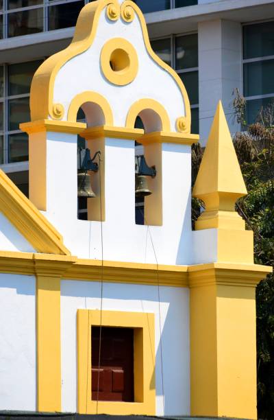
Church of the Immaculate Conception is a large pink building with a Spartan but brightly painted interior and a large statue of the Pope.
Central Market. Good for cheap food, drinks and fruit, but gets less busy by the afternoon.
Regional Museum of Cabinda. A building built by the Dutch in the 19th century has 380 modest exhibits showing the day-to-day life of the people.
Palace of the People. The governor’s residence is in a very nice African-style.
AROUND CABINDA PROVINCE
Cacongo (pop 20,000). Is a small, quaint, faded colonial seaside town about an hour’s drive north of the city.
Malombe Forest Reserve. Angola’s largest tropical rainforest occupies most of NE Cabinda Province. Heavily logged, it provided cover for separatists. The forest is at risk of disappearing, and the animal populations (elephant, gorilla, crocodile, chimpanzee, monkey, parrots and butterflies) have dwindled. It has no tourist infrastructure.
BORDER CROSSINGS
Republic of Congo/Cabinda
We sat at the border for 3 hours and talked to an Angolan man who had worked for Chevron for many years. He used to make money runs to the DRC and Congo, withdraw US$ from an ATM (this is no longer possible) and quadruple the money on the black market. The no-man’s land between borders was full of unusual carts with a guy steering using bicycle handlebars and someone pushing him.
Cabinda/DRC border. The border is only open from 8 am to 5 pm, and we were too late to cross, so we camped at the border in a large clearing, listening to the loud music from the local bar. Small groups of pigs grunted through the night. It rained lightly.
Ready to go at 8, we waited in the truck amidst 100s of flies for 4½ boring hours at Lufandika, Cabinda, for Steve to obtain the Cabinda, Angola exit stamps. The photocopies weren’t good enough, and all the passport main pages and Angola visas needed to be scanned – each passport took 15 minutes to do. We were the only ones to find lunch at a small hole-in-the-wall eatery right at the border barricade. I had a great bowl of beans for 200 kwanza.
We crossed at Ofida, DRC, where two immigration officers processed us in 30 minutes, only asking our profession.
We changed money on the DRC side. They would only change dollars – 1US$ = 1300 DRC francs (official rate 1320), but not €.
DRC/Angola Border
The crossing was due north of M’Banza, Angola. This was amazingly painless, but expedited by Steve having all the visas/passports scanned on individual pages – it only took about 2 hours.
The scenery has changed little – rural villages of mudbrick houses with a backdrop of grass fields, low bush and rolling hills, all significantly deforested. But it is all bright green and lovely. We bush camped about an hour past the border in the usual gravel pit. The road was good pavement, and the shoulders were interrupted inexplicably with several hundred meters of pot-holed dirt or pavement. The kids are like most everywhere with ready waves, screaming and big smiles. The adults, too, wave, give a thumbs-up and smile amidst their abject poverty. Washing clothes has a low priority, and all the men are absolutely filthy. Unlike everywhere else, lines full of flapping clothes are not seen.
The rusting hulks of cars, buses, shipping containers (five in one ditch) and semi-trailers litter the highway. The most common vehicles are motorcycles, three-wheeled carts of the “Keweseki” brand. At a gas station, cars were lined up four deep, all full of yellow Gerry cans being filled with gas for who knows where. Huge fields of cassava cover the hillsides but little is for sale along the roadsides. The school uniform is uniformly, for boys, a white, short-sleeved long “lab coat” and for girls, a white smock done up at the back. Impressive eroded cliffs of limestone were passed.
It is now only 3 weeks until I will leave the trip early in Namibia. The trip down through Namibia sees little while the trip back also traverses Namibia and sees much more. Namibia supposedly has the best scenery in the whole of West Africa and I don’t want to miss any of it if possible.
M’BANZA CONGO (pop 100,000)
This is a small town high in the hills in the middle of nowhere. Easy to be a tourist as can easily mistaken for anywhere in the Congo. French is widely spoken and ethnically the people are the same as in the Congo. Source of oil but petrol often in short supply.
Ruins of the Cathedral. The first place of Christian worship in Central Africa. Small, not maintained and likely deserted.
Museum of the Kings.
Governor’s Palace. Bright pink building with bust of Agostinho Neto.
We stopped in town to get SIM cards and data and for Steve to shop. The grocery stores all sold in bulk only.
We had considered driving south from M’banza Congo via N’Dalatando to the waterfall of Kalandula and the rock formation of Pedras Negras but learned from a Chinese fellow that the road was awful, so abandoned that idea and drove south west towards the coast and Luanda instead. The road is consistently good. At a plant for building electrical pylons, across the highway was a housing development with uniform, nice plastered homes, one section blue, another pink and a third, grey. If the forest were in a native state, we would call it a jungle. Tomboco was the main city between M’Banza Congo and the coast and we drove through at about 2 pm.
As we approached the coast, it became more arid, and a few baobabs and palm trees started to appear. The highway followed a line of huge power transmission towers but the lines were still not hung.. I assume this is a Chinese-funded project.
As the grass got drier, more was being burned, getting ready for planting. At N’zeto on the coast (247kms north of Luanda), we went down to the beach for half an hour and walked out to the pier.
Gas is the same price throughout Angola, 135AOA/l (about 40¢), compared to 1625 DRC francs (about $1.25), and that is why the gas station north of M’Banza Congo was so busy.
We bush camped on a beach south of N’zeto, Porta Pesquiera, 3 km down a dirt road. It was a long, gorgeous beach with great cliffs on either end. There was a police officer at the beach who did a complete passport and visa check. The water was warm and swimming good, and there were no bugs.
Shortly after returning to the highway, we passed an area of eroded boulders in great shapes. Baobab trees and a new kind of tree with a branchless trunk and a cluster of branches at the very top – a succulent with cactus-like branches?
The police checks are tiring, as they go through each passport and want us to identify ourselves. They smile and are pleasant, but what a waste of time.
We stopped at a wide, rocky-shored river, the southern border of Zaire Province and had a nice bath and clothes wash with the locals.
We entered Ambris, an old slave town built on a peninsula jutting into the ocean on the way to Luanda. Most of the businesses Steve was interested in were closed – the bakery and restaurant – but there were many pastel-painted colonial buildings, one in ruins, but most in reasonable shape. All the “socialites” had their noses buried in their phones, playing video games or in their Kindles. They see so little of the country we travel through. When we reached the market, Steve bought some much-needed vegetables and frozen chicken. I needed shampoo, but the only products for sale were skin moisturizers.
The highway is wonderful with wide, level shoulders bordered by a yellow line and a white center passing lanes that have meaning. The few homes are true hovels – some are scraped together from corrugated metal, wood and sticks, some are all thatched, and most are disintegrated mud-brick and sticks. The roofs are held down by rocks and bricks.
At lunch, we are swarmed by hundreds of wasps, eager for a drink of our wash-up water. They create havoc, especially with some of the troops. I realize they are only thirsty and have little interest in us, and do other people’s dishes. I don’t think anyone was stung.
The cooler, a great place to prop up your legs, was right in front of me. I wanted a few inches on one end, but Alice has splayed her legs across a foot of it, even though one minute ago I had my feet up there. I ask for some room, and she says no, demanding to have her legs directly out in front of her. I put my feet on the very edge and can’t help touching her. She gets pissed off, and the only solution is to simply move the cooler down six inches. Wow, go figure. I feel like I am on a separate trip.
After some large banana plantations, about 50 km north of Luanda, we drive next to the ocean and beach with a salt works and drying racks full of tiny fish. Cliffs at least 60m high head south. Then the land turns more arid with short brown grass, baobab trees, the succulent and large fan palms. A huge oil tank farm with 24 large storage tanks is signed China International Fund.
As Luanda is approached we passed about 20 restaurants all decorated at “banquet halls” – 20-30 tables with brilliantly coloured table clothes surrounded by chairs with white casings and ribbons. A huge water tanker filling station is passed with large vertical spigots.
Steve refuses to camp or stay in Luanda; the few campgrounds are very expensive at about $20 per camper and for some unknown reason wants to camp 50kms south of Luanda and then drive back to Luanda for one day. So we drove around Luanda to the east and south on a 6-lane highway. We passed at least three Cidade de China (China Towns), basically industrial parks. Many of the construction sites and businesses are in Chinese characters. A sea of residential skyscrapers was to the south. Estimates of the number of Chinese workers here was about 400,00 (some estimates put it a one million), as little as a year ago, but they seem to have all left. The truck drivers, heavy equipment operators and construction workers all appear to be black. Those high rises were originally built for the Chinese workers with the intent to become low-cost housing for Angolans.
Posters on the highway have Fidel Castro’s picture but, not able to read Portuguese, could not determine the message. Luxury gated neighbourhoods line both sides of the highway, along with all the businesses to support that lifestyle – furniture and household design stores. It is all very modern, upscale and new.
We eventually get back to the ocean and pass a lot of high-end houses and empty lots lining the highway with views down to the ocean.
MOON VIEWPOINT (MIRADOURO da LUA). 62kms from Luanda and 36kms beyond the museum. Soft reddish earth has been eroded to produce deep gullies and ravines that extend for 1km (I doubt this figure as the nice erosions extend very shallowly from the cliff edge and little past them is of much interest) across hillocky ground before eventually reaching the beach and the sea. The deserted beach stretches 30 km from Mussolo in the north to the Kwanza River in the south.


There is a small turnaround for the viewpoint just off the highway where we camped for the night. It is completely non-commercialized with no facilities, and there is no one else here. The eroded cliffs are in reality only about 20m deep and descend steeply off the viewpoint with a cascade of garbage covering all the quite spectacular erosions. There is no guardrail, and one walks right to the edge of the cliff. Much of the road turnaround has been eroded and is now blocked by a pile of gravel meant for eventual repair. The eroded cliff extends for several kilometres north and south, but this viewpoint is over the best of them. There is absolutely no way down the cliff, and what appear to be trails are simply narrow sand water courses. It took about 20 minutes to visit all the edges of the cliff and peer down at the erosions and garbage.
Anywhere else in the world, this place would be a park, a national monument and one of the major tourist sites in the country. Here, it seems of little importance.
We left the viewpoint at 5 am to miss all the traffic entering Luanda. As for the other two times, we have very early starts, and Tammy and Andy made sure they were on the beach and able to sleep. By six, there is a palpable anxiety in the other drivers on the packed 6-lane highway, and we were down to a snail’s pace by 6:04. The highway follows an impressive power transmission line – single poles of aluminum, a meter across at the base, 5 segments bolted together and 8 high voltage lines in four tiers. Almost all the cars are new – Toyotas and Hyundais predominate with fewer Kias, Fords, Chevs and many other Japanese brands. There are no taxis, but many blue and white shared vans that seem to provide all the public transport.
Garbage choked the waterways a few feet deep.
LUANDA
Situated about a quarter way down Angola’s Atlantic coast, Luanda is a vast and sprawling city. The population grew with millions of internally displaced people attracted to the relatively safe city, settling in shanty towns in the centre and outskirts of town. The population is between 5 and 8 million.
Since the end of the civil war in 2002, vast amounts of money have been spent to repair the city. The shiny new tower blocks owned by the oil companies stand in stark contrast to the modest houses and slums.
Yet ironically, Luanda ranks among the most expensive capitals in the world I which to live. Traffic is a major feature of life – personalized hummers and 4x4s compete with the blue and white collective taxis. Angolans go about their daily business: the brightly dressed female street vendors with fruit and veg piled on their heads and babies strapped on their backs, and smiling street lads trying to sell anything and everything.
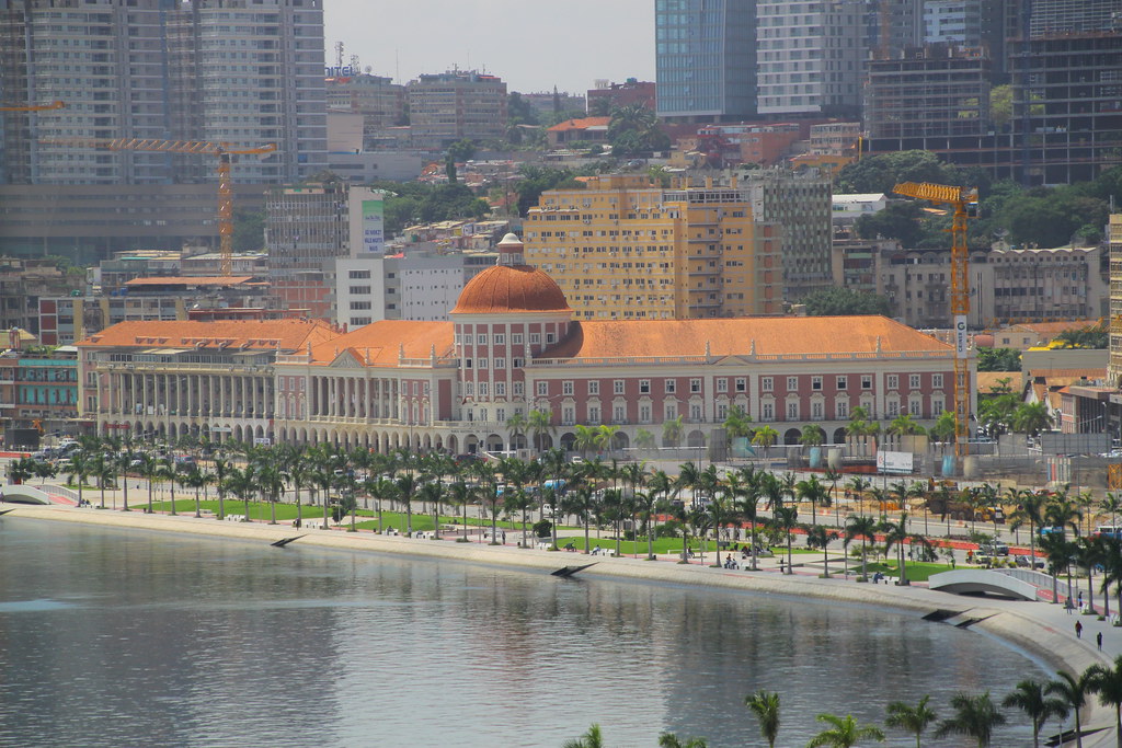
The Bay of Luanda is bounded by the Marginal and the 8km long Ilha sand spit with a 3km wide mouth, providing one of the largest natural harbours in Africa. It handles 85% of Angola’s imports and exports. It is chronically congested and often has thousands of containers awaiting clearance, so delays of 3-4 months are not uncommon. It has no passenger services and is of no interest to visitors.
Marginal Road. This follows the bay and is the main focal point of the town, looking resplendent after a multi-million-pound makeover. It stretches 2.5km from the port in the NE to the Fortaleza de Sao Miguel in the SW. Most visitors will spend quite a lot of time here, mainly stuck in traffic. Landmarks from the north end are the Le President Hotel opposite the imposing clock tower.
Church of the Nazareth,
The imposing pink National Bank, Luanda’s most recognizable landmark.
Just after the post office, take a side trip to visit the Church of Our Lady of Remedies and the new, futuristic, silver Sonangol skyscraper.

Back on the Marginal is the new skyscraper, Torres Atlantico. 200m down is Largo de Baleizao on Cuba Square, laid out in 1765 with its 18 tall stone statues, gifts from Cuba. Last is São Miguel fort.
Ilha. An 8 km long sand spit that creeps out to sea and forms the outer arm of the bay of Luanda. It is 500m wide at its widest point and 100m wide at its narrowest point.
Everyone – expats, Angolans and tourists – comes here to enjoy the many bars, restaurants, nightclubs and the beach. Storms still occasionally cause damage, and the Atlantic rollers sometimes wash across the narrowest parts. In the late 1960s, the wooden bridge that linked Ilha to the mainland was replaced by a short causeway, but it continues to be the Ilha (the island). Dams on the Kwanza River, 80 km to the south, are holding back huge amounts of sediment that in the past washed north by the tides, so the Ilha is gradually being washed away and is not being replaced.
The bars and restaurants are interspersed with slums and beggars, and mugging is a problem. Hotel options are limited with high prices. The water on the Atlantic side is cleaner than the bay, which is polluted and can be smelly. Some of the bars/restaurants have free wi-fi. There are great views of the city: the Baixa, the crescent-shaped Marginal and the rest of the city, especially at night.
Praia do Bispo and the Space Rocket. Where the Marginal meets the Ilha, the main road continues south through the once posh suburb of Praia do Bispo. Houses once on the waterfront are now separated by 500m of slums. At the end of the neighbourhood is the 120m high space-rocket-like monument at the Mausoleum of Dr Agostinho Neto, Angola’s first president (died in 1979). Costing anywhere between $5million and 100 million, it was to include the embalmed body, but the embalming was not done well, and it deteriorated, so it now contains his sarcophagus.

Luanda Sul. Built in the 1990s, this suburb, 15 km south of the city, contains smart ultra-modern offices and residential compounds protected by extreme security and high walls. It is home to wealthy Angolans and oil-rich expats.
National Museum of Anthropology. The most interesting museum in Luanda, it gives a look at old Angola in the 18th-century pink former headquarters of Endiama, the Angolan diamond company.
Natural History Museum. Worth the entry fee and 20 minutes, it has old, badly stuffed fish and birds with information in Portuguese only.
Museum of the Armed Forces. In the fort, it has the radio car operated by dos Santos, the current president, during his time as an active combatant.
My Experience
We drove the length of the Ilha. The two “green spaces” on the peninsula were unkempt, covered in garbage and appeared to be used only by squatters. I didn’t see all the splashy bars, clubs and restaurants I expected on the 8km length of the Ilha. The end was industrial and underwhelming, not the “smart” parking and restaurants one would see anywhere else in the world. We stopped there for breakfast out of the truck. The 40m-deep beach on the ocean side was littered with garbage.
Steve drove up the hill to the parking area at the fort. It was free so his plan was to stay there all day and then move down to an expensive parking area below the fort at 4pm. So that gave us about 7 hours in downtown Luanda to explore.
Fortaleza de Sao Miguel. Besides some army paraphernalia, the only reason to go is the great views of most of downtown Luanda, well worth the price of 100AOA.

I walked out of the fort with plans to walk along the escarpment through Cidade Alta. This suburb above the rest of the city has good views and houses the Presidential Palace (1607-11, closed to the public), government buildings and São Miguel Fort (1576) with its panoramic views of the city. But there were army everywhere, and I could not enter. So I descended and walked through the Baixa. This is the vibrant commercial and historic center of Luanda with its old colonial buildings, narrow streets and small shops hidden away on back streets. Miramar, Alvalade and Maianga are residential suburbs, home to many expats and rise above the Baixa.
I went into the Church of Our Lady of Remedies, with its lovely wood ceiling and Portuguese style statues. I then found the Church of the Nazareth (1664), renovated in 1995 with a lovely wooden ceiling, paintings and hand-painted Portuguese tiles. The church itself is small and not imposing from the front, where there is a nice garden to sit. But it is lovely inside. Both churches had about 10 older women praying in them.
The best internet/wi-fi access is at the hotels. So I walked to the end of the Marginal and the President Hotel. I bought a beer for $1.50 in the 8th-floor bar (very nice) with views across to the Ilha and used the internet for 3 hours. It has a lovely outdoor deck.
I continued back along the Marginal and went into the imposing pink National Bank, Luanda’s most recognizable landmark and perhaps the finest remaining example of Portuguese colonial architecture in Angola. The lobby is adorned with blue-and-white Portuguese tiles.
Instead of driving past the Miradouro da Lua, we returned to Luanda to head east for Malanje Province to see Pungo Andongo (Black Rocks) and Kalandula Waterfall
SOUTH OF LUANDA
We only went to the Moon Viewpoint.
Benfica arts and crafts market. 100 stalls sell wooden souvenirs, jewelry, textiles and ornaments.
Slave Museum. On a rocky promontory facing the Mussulo chain of islands. Museum in 17th century Capela da Casa Grande. Slavery was abolished in Angola in 1858. Labelling in Portuguese.
Moon Viewpoint (Miradouro da Lua). 62kms from Luanda and 36kms beyond the museum. Soft reddish earth has been eroded to produce deep gullies and ravines that extend for 1km across hillocky ground before eventually reaching the beach and the sea. The deserted beach stretches 30 km from Mussolo in the north to the Kwanza River in the south.

Kwanza River. Rises in central Angola and flows 960 km to the estuary. Heavy police or military presence here. The main span is 269m long, and the overall length is 420m.
KISSAMA NP. 82 km from Luanda is the most accessible NP in Angola; it has few animals but offers stunning views of the Kawa River. 80 km south, it is possible to see as a day trip from Luanda. One of Africa’s largest, emptiest and most surreal wildlife parks.
We left Luanda at 4:30 to try to avoid the late traffic. Steve has decided to head east to the Black Rocks area and Kalandula Waterfalls, 400 road kilometres away. We bush camped on St. Patrick’s Day, pm a power transmission line right-of-way right next to the highway and a hill, so there was considerable truck noise all night. And it started to rain just as we finished breakfast. It was a lovely, cool drive in the rain all day. After an hour, we drove through a great baobab forest. The great quality highway is through one of the more mature forests we have seen since Cameroon or Gabon. But the villages we pass show some abject poverty with tiny shacks with corrugated metal or wattle (sticks and mud) construction. Nylon sacks of charcoal line the highway; this may be their major economy.
We stopped at a roadside vegetable market: yams, cassava, tomatoes, onions, green vegetable (cassava tops – very common), eggplant, potatoes, oranges, limes, avocado, banana, plantain and meat: bush meat, grilled pork, hot dogs with onions.
These must be the largest power transmission lines in the world, with 8-9 high voltage lines on massive towers. But within two hours, rampant deforestation had reappeared.
KWANZA NORTE PROVINCE. The northern part is dense tropical forest, and the south is savanna. It is crossed by the Kwanza, Zenza and Lucala rivers and has a tropical, humid climate, with October to April being the hottest. With rich agriculture, before the war, it was known for cotton and Robusta coffee, but it has declined significantly since then.
N’DALATANDO. This provincial capital of Kwanza Norte Province is 780m above sea level. During colonial times, sleeping sickness and malaria were rife to the point that the locals changed the name to Dalamatando (a play on words meaning killing). It was a garden cutie that used to grow flowers for Luanda. The old botanical gardens are now neglected and overgrown.
We passed through N’dalatando at 11 am. The town had some very unusual features: the bank extending down to the highway was planted in either lovely grass with shaped flower beds or completely with wild flowers, while the boulevards were also grass. There were guys in bright green shirts maintaining it all. Strange.
MALANJE PROVINCE
This province sits on the central plateau in the north of Angola and shares its borders with the DRC and 6 provinces of Angola. The altitude varies from 500m to 1500m with a humid climate and temperatures ranging from 20-25°. The rainy season is from August to May, the coldest month is June and the warmest March and April. The province was once a vitally important agricultural area, principally for cotton, but the war brought years of neglect and stagnation. It is now slowly recovering, helped by the Brazilian donation of US$10 million to develop maize and sugarcane around Pungo Andongo. Hydroelectric power and minerals such as copper and manganese are important parts of the economy.
History. In 1961, cotton workers protested violently against appalling working conditions and forced labour. The Portuguese authorities responded with force, including bombing with napalm, and thousands had been killed within 3 months. 40,000 died from the bombing, subsequent disease and starvation and 17 villages were destroyed. January 4 is a national holiday, remember the massacre.
Later, Malanje suffered again in the civil war with heavy fighting throughout the province. A large proportion of the labour force left the mined fields for the relative safety of Luanda.
On the way to the Black Rocks, we passed a massive sugar cane operation owned by Unidade Cacuso – endless miles of cane with a massive factory in the middle.
PUNGO ANDONGO
Midway between the cities of N’dalatando and Malanje in NW Angola are an astonishing collection of black rocks. Covering a rectangular area of 12km X 6km, are colossal blocks of stone, many of them rising 200m above the surrounding flat savannah. Further to the east is a second group of rocks called Pedras Guingas. Many of the rocks are described as looking like animals but at least one looks like an enormous circumcised phallus. Geologically, the rocks are a mystery: they are hard sedimentary conglomerates but are out of character with the surrounding topography. The growth of mosses and algae causes them to change colour during the seasons.
Pungo Andongo is a place of myth and legend with the footprints of kings supposedly embedded in the rocks. Legend has it that while a queen was taking a bath at the foot of the rocks was seen by soldiers. As she fled, she left behind her footprints, now protected by an ugly concrete shelter.
A military fort was founded here in 1671. It became so famous, it was known in Portugal and used as a threat to children. During the political unrest of the 1920s, many political prisoners were kept here and during the civil war, it was a battleground between UNITA and MPLA forces. Spent cartridges still litter the area and was still mined in 2008, so be careful wandering off the trails.
How to get here: at the village of Caruso, the road rises over the brow of a hill and the rocks appear majestically in the far distance. As you enter a small settlement, sighs point to the left and park in a natural cul-de-sac between the rocks. The old visitor’s centre has disappeared but old concrete steps lead to the top of one of the rocks with an astonishing view of the countryside for miles around.


When driving, a large number of domes appear first but these are several kms north of Pungo Andongo. The road runs to the west of the most interesting set of the rocks, you pass through a village and turn east and climb up into the center of all the domes. A right turn takes you down to a parking area (no services) and two small concrete enclosures with roofs, each with great footprints with perfect outlines and 5 toes. A stream runs at the base of the rock and most everyone washed and did washing. The police arrived and said we must camp in the town at the end of the road about 500m north. There are about 10 houses, a school, an administrative building, an octagonal toilet and a clinic but few people, all set amongst about 10 domes.
Several went walking to get a view of the rocks on the west side. I made the mistake of going into the town and asking a fellow for the “miradores” (viewpoint). He was drunk, spoke only Portuguese, didn’t stop talking and led me on a wild goose chase through the school and up a small dome just above the town that dead ended on a cliff with no views. I wandered around for an hour but could not find a way through the dense bush. The route taken by 5 of the group became apparent up a ridge just south of the town (marked by a 4 foot piece of round concrete and an inverted upside heart on the north side). It is an easy scramble to a great viewpoint to see all the good rocks.
We camped in the town on a big slab of pavement. Up at 5:30 for breakfast, Soto and I climbed the rock to the south of the town, but the best views to the west were obscured by another steep gully and a dome. But we had great views to the south to the 110m high Capanda Dam on the Kwanzi River built by Brazilians and Russians between 1986 and 2007 (interrupted by the civil war for over 5 years. It produces 520MW of electricity and cost $4 billion to build. There is a large reservoir to the east of the dam. The Kwanzi River drops 1000mm over the next 100kms and has the capacitiy to build 3 more dams of Capanda’s The views to the northwest showed the top of some of the pinnacles – one with a massive cleft down the middle and the phallic rock. We saw what we thought were goats or antelope but were actually baboon-like mondey. Others saw a jackal the day before. Most of the others climbed a rock to the east with a building on top. But the views from there were just of more less interesting domes. Hiking here would be very challenging as the domes are separated by very steep-walled gullies choked with bush. Many of the walls would be unclimbable.
On the drive out, views from the road were of an incredible array of pinnacles along the entire west and north west of the area. But there is no viewpoint per se. This is a spectacular area not to be missed. Tammy’s highlight was being able to cuddle a puppy – and probably get fleas.
We stopped for a pee at a rise the entire south skyline was dominated by the domes and pinnacles of the series of rocks north of Pungo Andongo. The tiny collections of mud brick hovels had thatched roofs covered with plastic sheets.
KALANDULA WATERFALLS (CACHOEIRAS DE KALANDULA)
These waterfalls on the river Lucala are either the second or third tallest in Africa at 105m and are about 400m wide, so are spectacular. They are best in the rainy season from September to April (rains are heaviest between November and January). The closest town is Malanje, some 85km to the east, but a hotel has opened in the nearby town of Kalandula. There is no fee.

There is a good view of the falls from the 1960s white concrete vantage point. It’s possible to walk upstream and above one side of the falls from the miradouo, scrambling over the rocks. Look for names carved into the stone, some dating from the 1920s. The rocks are full of vertical holes and potholes, and one can only imagine the water levels to have produced them. There are no guard rails.
A highlight is to walk down to the base of the falls. Walk about 100m up the road and turn left down a 2-track road to where it ends. There is a long rusty pipe sticking out of a concrete pad, and turn left here down the path through the grass. The path is initially steep and a little slippery, but it becomes gentler nearer the river. Scramble over rocks and roots for about 10 minutes along the river, with the last 20m very wet, 6” deep mud formed from the spray of the falls. Flip-flops are best – remove them for the mud, it is safest to step in the deep spots rather than the slippery rocks and logs and wash it all off in the river on the return. Reach the base of the falls in 20-25 minutes, but this would be very slick if it has been raining. The falls are spectacular from the viewpoint and more so from the bottom – easily one of the prettiest waterfalls in the world as they cascade over the entire 400m lip. The water is greatest nearest the viewpoint so going to the bottom allow seeing this part of the cascade the best. Bird watching is good in the gallery forests along the river and the miombo woodland in the surrounding area.
You will be hassled by kids to guide you down, but they are completely unnecessary. Make sure they stop following you, as they will then demand money – 2,000AOA is the standard amount.
How to get there: Look for signs to the colonial name of “Duque de Bragança” rather than Kalandula. Ignore the signs of the derelict hotel, and the access bridge has been destroyed. The depressing road passes through many settlements destroyed during the war. In 1984, the infrastructure of the town of Kalandula was destroyed, and the majority of the UNITA population moved to the safety of Malanje, Cacuso and Luanda. There is a bombed-out cinema, houses and shops, but the impressive mission church built in 1958, a few kms from the town, survived and is worth a quick side trip to see a Portuguese-style church incongruously transplanted into the middle of nowhere. This is popular with hundreds of people in overloaded cars, vans and trucks, especially on weekends. Visiting during the week is best. There are no services or shops, but a few women offer food. There are two nice round shelters that the locals use to BBQ and play music. We camped next to them for the night.
CANGANDALA NP
30 km from Malanje, this 600 sq. km park of miombo and poorly drained savannas is the smallest in the country. It was originally founded to protect the giant sable antelope that were discovered here in 1963. The park was closed for 13 years until 2008, so the vegetation is in excellent condition, but the fauna has been seriously depleted by poaching, human encroachment and charcoal production.
The park is actually managed, but has no tourist infrastructure. There are also roan and duiker antelope, bushbuck, wild boar and an endemic frog.
We left at 8 am for a long drive day, retracing our steps as far as N’dalatando, then turned southwest heading for Sumbe and the coast. The good road travelled through a very nice rainforest with some big trees. And then hit the savannah just before we crossed the Kwanza River, the classical boundary between rainforest and savannah.
KWANZA SUL PROVINCE
It rises from the coastal plain (180 km long coast) to the rainforest-covered mountains of about 1,500m in the interior. It’s cooler on the coast, and temperatures rise inland. The warmest months on the coast are January to April.
We turned south at Dondo. On the banks of the Kwanza River, it was once a slave trading town, replaced by cotton, beeswax and coffee. But the railway bypassed it, and it declined to a dusty, sleepy town. Eka beer is brewed here. Nine kms south is the 102m high Kambambe dam (1958-62), 200km downstream from the Cabanda Dam and the final dam on the Kwanza River.
Steve had driven this road three years ago, and it was new and in perfect condition. But now it was riven with pot holes every 50m, and we averaged 15km/hour.
After dark, we finally bush camped 70 km from Quibala right next to the road, with trucks roaring by all night. Nose ring and Anders had their first major fight. We have a lottery to try to predict the outcome. Dinner was late, and Tammy, always in bed by 8, missed one of my best meals – we had chicken breasts that we cut up, floured, sautéd and served with pasta. The road turned to much faster, graded gravel. We travelled through high savannah with a backdrop of high hills. Houses were mud brick with thatch as common as corrugated – the wealth of the owner could be judged by the number of rocks holding down the roof. Skinny cattle, pigs, goats and dogs were the wildlife amid banana, cassava and yams. Many of the adults and children simply stared in wonder as we drove by.
Gravel pits, bitumen plants, heavy equipment and road crews building drainage appeared along the side of the fast, hard-pack road. Chinese bosses direct Angolese workers. An amazing number of shipping containers litter the ditches, and we passed two rusted tanks. A large bitumen plant with “Pan China” was set up to begin the paving. The hills have rocky cliffs and outcrops, and it is very pretty country, all lush and green.
After 2 hours, we passed a massive agricultural project – 500 greenhouses, then fields of citrus, newly planted trees, and large fields with pivot irrigation.
The pot-holes returned, and after 2¾ hours, we turned east on EN240 at Quibala. A strategic point, it suffered heavily during the war, with tanks and ruined buildings still in evidence. It is on an agricultural plain, the breadbasket of Kwanza Sul, producing coffee, cotton, sisal, banana and pineapple, corn and rice, but all were destroyed during the war. Since 2004, in partnership with the Israeli government, agriculture has been returning. Just after, we passed some great sheer-walled granite domes.
The great highway climbed high above, and we passed through several small villages with equally good scenery (more domes, coffee plantations, palm trees)until we arrived at Gabela after 4¾ hours of driving.
Gabela once had a thriving coffee industry and once had its own railway to take coffee and bananas to Porto Amboim for export. But now its ramshackle buildings give it a sad, neglected look, not helped by the cool, damp climate. We drove into downtown Gabela. Seven of us went to a café for burgers and fries. But there apparently was an option for a truck lunch and the cheapos (Tammy and Andy have never missed a truck meal yet, Julia and Tom, Blake and Bob) took full advantage – leftovers from the tasty chicken/pasta left over from the night before. Only Blake thanked me for the food. Gabela supposedly had “tons” of art deco buildings, but all I saw were a few run-down colonial buildings – certainly not the art deco I was used from South Miami Beach or Napier on the north island of New Zealand.
Nearby is the Kumbira Forest, an important birding area, with more than half of Angola’s 14 known endemic species of birds. We see a lot of spectacularly coloured birds from the truck.
We descended from Gabela with baobabs and quiver trees reappearing in the more arid landscape.
BINGA WATERFALLS. 26 km from the coast, we crossed the Keve River. Four small cascades start at the new bridge, continuing under the old bridge and down to the lip of the falls 150m downstream. Take a short road to the north to view these short, wide falls with a deep pool and a swim. The large amount of spray prevented long exposures. Admission was 150AOA. Steve wanted to camp here, but the fee was $60 so we didn’t.
After a short drive, we pulled down a narrow dirt road for 500m to the bush camp. It poured for an hour and then rained intermittently overnight. The road had turned into a greasy mess, the kind of mud that sticks an inch thick on your shoes. We got stuck six times before we regained tarmac 2½ hours later – the first with the truck loaded 2m from where we started, and with the third, we were angled 30° to the road. The slight slant of the road encouraged the truck to slide downhill. That third episode took about an hour to dig out. Pushing an 18-ton truck would have been of no value, but pulling may have helped. It was good that we had a lot of bodies to do all the digging using 5 shovels, an axe and a pickaxe.
When asked about how that rated to his other times stuck, it was “nothing” as he was stuck innumerable times, much worse. One episode involved stacking the wheels of three trucks into the mud. The landscape turned much more arid with cactus and scrub brush.
SUMBE. Back at the Atlantic coast, this city is a mix of once elegant Portuguese colonial buildings, shabby grey apartment blocks (a legacy of the Cubans), and, on the outskirts, mud houses. Can swim, but not much else to do. We stopped for lunch in the rain on the beach. The bank leading down to the sand was littered with most of the town’s garbage.
I stopped at a pharmacy to deal with the infected sore on my left ankle. Every skin break, especially on the feet and ankles, gets infected in these countries. Steve thinks it is the heat and humidity, and how dirty our feet are. Sitting for long periods, travelling with resultant extra fluid retention must be a factor. Personally, I think it is all the flies – any wound will have 5 on it within seconds of not paying attention. Who knows where they’ve had their feet? I had some old dicloxacillin that had treated the surrounding cellulitis, but needed some antibiotic ointment, band aids and more flucloxacillin.
CUBAL RIVER GORGE. South of Sumbe, this steep-sided gorge and fast-flowing river is crossed by the main Luanda-Benguela road. Bananas are sometimes brought downriver on rafts. Crocodiles are in the river.
Steve had to swerve all over the road to avoid all the potholes. The highway deviated inland through desert scrub: sand, scrub brush and lots of prickly pear.
Then we came upon a big accident completely blocking the highway. Finally the causative vehicle pulled over and smaller vehicles could pass, but a huge traffic jam resulted when vehicles too large for the gap tried to get through. Nobody was in charge. Steve finally hooked up a cable and pulled the vehicle over and everybody could get through. What a mess. We were held up 1 hour and 40 minutes until 16:30.
THE BALLOONISTS. In the afternoon, we ran into Chris Davis and his wife, the two Brits who are trying to set the world record for countries a hot-air balloon have been flown in. We first met them in Ghana and then again in Gabon. They presently have flown in 93 countries, #2 is another Brit at 94 and #1 is a Brit/German couple at 113. But he has some unusual advantages: he worked for Cameron Balloons and went to 50 countries that his company had sold balloons to; and then he had a deal with British Airways to fly in all new countries they served and flew him to each of them; he has now bought an airplane and is in the Caribbean.
Chris is 69 and has been flying balloons since 1991 and owned a company selling balloon rides in England from 2003-2013. He has had the idea of flying in most countries since 2008. This trip down the west coast of Africa has added 13 countries to their list.
The entire balloon kit rides in a big box on the back of their motor home. It weighs 375 kg, including the “basket” (aluminum, composite), propane tanks and the envelope that weighs 75kg. At most, there can be 2 passengers, and it is usually him and his wife. They use a cold air fan to do the initial inflation and then heat to actually fly.
The procedure is to first find a landing zone, then assess the wind direction and speed using a small balloon. The landing zone can be as small as half a football pitch, but sometimes 10 times that size is necessary if there is more wind at ground level. They then find a take-off location. Airfields are the favourite as a flight counts if it is at least the length of an airfield. Wind speed varies with altitude, and a GPS and an altimeter are used to fly. They also carry a VHF radio and telephones to communicate. Most often they fly just over tree height but have been up to 5 miles up over the Alps in Austria.
It requires a special balloon flying license (part is similar to a fixed-wing aircraft license) but qualifications are rarely requested.
The most difficult flight so far was in Abuja, Nigeria. When they landed, there were 200 people there, and in no time, there were 500, including 2 gangs, each demanding money. The gangs eventually started fighting, and Chris was able to escape without paying anything. The flight here in Angola was to a military air base, often a very difficult place to jump through all the bureaucratic hoops necessary.
Tears in the lower quarter of the envelope are not that serious but anything in the upper ¾ prevents flying. Small tears (1 inch) are repaired with a special tape, larger tears with tape on both sides plus sewing and tears up to 12” can be repaired by special balloon repairing companies.
I asked for his web site address in order to follow his progress. At present the only people with access are family. Making it public would give too many advantages to his competitors.
We started March 23rd off in sunshine after 2 days of rain. The eastern skyline was a long rocky ridge filling the horizon. An amazing number of women were walking along the highway with no discernable destination anywhere near. Palms and bananas reappeared and the large market in a town had a complete selection of every vegetable. But there is none of small-time industry seen in the rest of western Africa – metal doors, concrete block, furniture. The fields were full of people planting. The landscape very much resembles the Sahel, the northern boundary of the deserts south of us – short grass, prickly pear, bush, the occasional baobab.
LOBITO. A weekend retreat for Luandans. Little to see or do other than enjoy the 4km of beaches on the Restinga sand spit, some colonial buildings and a few Art Deco buildings. On the outskirts, riven with rocky ravines, were rusted out car wrecks and shipping container homes. In town: building supply and house ware stores, motor cycle repair dudes and lots of hair salons competed with all the street vendors: clothes, shoes, sundries, fruit. All the side streets, as in all of Africa are muddy lanes, the water courses filled with garbage, dumpsters overflowing. Garbage tips proliferate. With all the rain, pools of water and mud filled gutters are every where. All the banks have guards with AK47s. We have been looking for diesel for the last 24 hours but all stations have none.
The port is huge with containers and oil. Just past we drove down the Ilha-like peninsula – basically a high-end residential district and few businesses. In a massive roundabout sat the small ship from which the revolution was launched. At the end are several high end restaurants and beaches. At the very tip is a grey rock breakwater obscuring the view, a rubbish tip, a small, garbage-strewn beach where the four lifeguards are discouraging swimming because of the undertow, and a shuttered restaurant. Some went swimming.
BENGUELA RAILWAY. Built between 1903 and not finished until 1931, this 1,334km long railway connects the Katanga region of Belgian Congo with Lobito in Angola. The Katanga has a 400km-wide copper belt, one of the richest and biggest in the world.
Cheaper than crossing to Mozambique, it entailed building a new port in Lobito, plus was 4,800km closer to Europe than East Africa. Construction was formidable, crossing mountain ranges and deep valleys. Its high point is 1,722m above sea level, 380km from Lobito. 5,000 men from the West Coast and 2,000 Indians from Natal worked on the railroad. Supplying food and water was a logistical nightmare. Hot temperatures, sleeping sickness, beriberi, malaria and wild animals all took a toll.
Over the years, millions of tons of copper, zinc, cobalt and manganese were transported from mines in Zambia and Congo to Lobito. Wood-burning locomotives were used, and eucalyptus trees were planted to supply wood. In the 1960s, the railway was Angola’s largest employer with 14,000 employees. The civil war took a heavy toll, and the Angolan government has spent $2 billion to demine, repair tracks, rebuild stations and track with money coming primarily from China. It reopened in 2013.
BENGUELA. One of Angola’s most picturesque cities with deep blue ocean and a long sandy beach, green palm trees and crimson acacias with pastel-pink colonial buildings set around open squares. Chill out on the blissfully empty beaches of Angola’s most laid-back town.
Church of Our Lady of Populo (1748). First building in Benguela to be built of stone.
We stopped in Benguela for an hour. I went to a coffee shop and had great internet. The search for diesel continues. Virtually every station has none, and the one or two that do, have kilometre-long lineups. Instead of taking the coastal route to Namibe, possibly the last place to get gas in Angola, we are going via Lubango (which will more likely have gas, is higher altitude and a nicer place to spend a few days if we have to wait for gas). Steve decided not to go to Namibe at all.
NAMIBE. A dusty fishing village sandwiched between spectacular sandstone cliffs and the deep blue bay.
Arco. This is a freshwater oasis 85 km south of Namibe, which boasts some spectacular sandstone arches.
We climbed up through a lovely area of low mountains covered with broken rocks and boulders. To the east, they were much higher. Baobabs were common.
Steve is not infallible. The entire southern sky was black and pockets of rain could be seen in the distance. It was 5 pm, and we stopped at a very wide turn-off with a narrow road coming off it. He is obsessed with staying as far off the road as possible. Instead of staying there (even though it was right on the road) and getting our tents set up when it was dry, we ended up driving into the most incredible rainstorm, eventually parking beside the road and setting up in the dark and rain.
Off at 7 am, the drive travelled over a 1600m plateau of flat savannah–grass, small bush, maize and all the same grinding poverty seen in so much of rural Angola. It was refreshingly cool after heavy rains and then overcast. You can always put on more clothing.
Another rainy day. Diesel was available at a tiny town 100 km before Lubango. We arrived at Lubango at 3 pm and drove through town on our way to the volcanic fissures.
TUNDA-VALA VOLCANIC FISSURES. Cut into the Chela escarpment. Is 17kms NW of Lubango. Wide, high plain with a moonscape of weird-shaped rocks, many of which have been stacked precariously on top of each other by nature. Viewing platform above a deep ravine slices into the edge of the vertical cliff. At the bottom of the cliff, some 1,000m below, is a wide green plateau punctuated with odd-shaped hills that stretches to the sea over 130km away at Namibe.
I have never seen anything like this place (as had Chris and Sue, the balloonists with about 120 countries). The fissure (an earthquake fault zone) is wide and amazing from the viewpoint. It is a short walk out to more viewpoints on the edge of the escarpment. It was raining, creating great light down to the plain far below.
We camped near the viewpoint amid the rocks. There was a wonderful pink sunset and a rainbow. It rained and blew hard for most of the night, but it was gorgeous the next day. The drive down passes great, broken rock formations covered with orange, grey and green lichen and a waterfall set back in a rocky canyon.

SERRA da LEBA PASS. 36kms from Lubango, the road plunges 1,000m down the Serra de Leba escarpment in a series of hairpin bends. Breathtaking views of the valley below. The excellent tarmac road was built in 1970 and is regarded as the best-constructed road in Angola.
At the campsite at Tunda-Vala, I met an Angolan woman on a motorcycle tour of Angola. She told me (and subsequently Steve) about a circle route that added 20 km to return to Lubango. It meant going to the bottom of the plain and returning by some wonderful coloured rock formations and a waterfall. Steve described the drive in the most unappetizing way and put the proposal to a vote: do the extra drive or return to Lubango to go shopping. Only 5 of us voted for the drive! And we didn’t go. We were heading down the switchbacks to a viewpoint, and it was decided to repeat the vote when it was obvious that the vote would have changed for the drive. When we reached the viewpoint, Steve simply turned around; we didn’t stop, and the vote was not taken again.
I am so totally tired of this trip. I can’t wait to leave.

LUBANGO, HUILA PROVINCE
1700m above sea level, it is the highest city in Angola. The climate is hot and humid during the day and cool at night, with the heaviest rains from January to March. It missed most of the civil war as it has no oil or diamonds.
Almost untouched by war, breezy Lubango offers cascading waterfalls, spectacular volcanic fissures, and a vibrant small-city ambience.
Statue of Christ (Monument Cristo Rei). About 300m above the city, this is a smaller version of the famous Corcovado statue of Christ in Rio de Janeiro. There are 180° views of the city below with the Chela mountains behind. The 30m tall statue was built of brilliant white marble between 1945 and 1950. Christ, arms outstretched and mounted on a pedestal, has bullet holes on his face, bad teeth and missing fingers on his left hand.
One of the most unusual things on the whole trip was in Lubango. Troops of 2 or 3 adolescent girls walked around bare-breasted. Their hair had red, clay-like attachments. They begged for money and apparently posed for photos. Some were in very early pubescence, and one was in her 20’s and had a child. When money was given to them, men came and claimed most of it. They belong to the Mumuila tribe, and this practice only occurs in Lubango Province.
We talked to a black guy who had lived in Namibia and spoke great English. There was a woman there who looked kind of rough, and we asked many revealing questions. Sexual activity if very free – everyone has sex with whoever, and money usually changes hands (although he said they would not have to pay if you took them to a movie or bought dinner). This girl would have cost him 2000AOA ($6.50), but she would have charged a white guy more. She preferred anal sex. No wonder HIV is so common here, but much more common in Namibia, Botswana and South Africa.
We camped next to Cristo Rei as it is free and quiet. There was a nice concrete walk around it to put up tents during the torrential downpour at 8 pm. The statue is kind of decrepit and needs a paint job, but there are great views down to the city.

Instead of going up to Chisto Rei with the group, I stayed in town to eat western food and see more of the city. I walked down to Centro but ii was very run down with few restaurants or stores. I returned to the restaurant where there was great internet, had dinner and hung around writing till 11pm. It then took 2 hours to get a taxi – they are rare in Lubango and busy so finally arrived up at the monument at 1:30. The next day we returned to ShopRite to shop. Out of 10 gas stations, only one had diesel.
We left Lubango at 10:30 and drove through high savannah of grass and bush. After lunch, Steve got stuck exiting the lunch spot and we acquired 15 locals, mostly women nattering at us – wanting money and food, but also cutting branches for traction. One woman never shut up the whole time and her husband covered his ears to say how he dealt with her. Five women had babies and they demonstrated the most creative angles to breastfeed babies.
It is 500kms to the Namibia border and it took us two days. The scene out the window at around 200kms is quite different from elsewhere on our trip. Rarely are their homes along the highway. But trails lead every where through the sand/short grass/ dense bush to tiny collections of the worst housing on the continent – most often stick walls with thatch roofs, occasionally corrugated or wattle walls and rarely plastered mud brick, really only in towns where they all are. One to four houses sit well back from the highway next to large fields of maize protected by brush fences. The land is completely flat and a lush green. Cattle – of every hue imaginable, usually long horned and well fed – are very common. Occasionally there are goats, also of every color variety, and the rare donkey. Thin, saggy- breasted women, usually with a baby on their back often are walking on the sides of the road.
A few baobabs appear at km280 and another unusual palm tree with branches extending the entire trunk giving it a shaggy dog look. Also triangular termite mounds that looked like sharp peaks. The land at 300km is dead flat with tons of standing water. We filled with diesel at Xangongo, set on the only elevated land around, and were on the search for a bush camp amidst all the water. Large parts are one giant, very shallow lake with bright green grass growing all over, very pretty.
Mupa National Park. In the far north of Cunene Province, once a thriving game preserve known for its giraffe, by 1974, all the giraffe had been wiped out. The park is barely protected and plenty of Angolans live in it and have developed small agricultural plots, especially along the river. There is little to see for a casual visitor – and indeed, tourists are not encouraged to visit.
Ondjiva. This is the main bus stop and trade route between Luango and Namibia. The vast and empty desert in Cunene Province has more cattle than humans.
Angola/Namibia Border March 27, 2017
Santa Clara, Angola to Oshikango, Namibia
It took about 1 ½ hrs for everyone to be individually stamped out of Angola, then it was a long walk along walled walk-ways to the Namibia immigration. After filling out a form, it was a fast 5 minutes. There was a KFC down the street and most had the first feed of American fast food in several months.
