
Senegal – Dec 9-16, 2016
Senegal is bordered by the North African country of Mauritania in the north, Mali to the east, Guinea to the southeast, and Guinea-Bissau to the southwest. Senegal further borders the country of The Gambia, a sovereign enclave occupying a narrow sliver of land along the banks of the Gambia river, which separates Senegal’s southern region of Casamance from the rest of the country. Senegal also shares a maritime border with the country of Cape Verde. Senegal’s economical and political capital is Dakar. It is the westernmost country in the mainland of the Old World, or Afro-Eurasia, and owes its name to the Senegal River, which borders it to the east and north. The climate is Sahelian, but there is a rainy season. It is a transitional ecoregion of semi-arid grasslands, savannas, steppes, and thorn shrublands lying between the Savanna to the south and the Sahara to the north.
Official Name. Republic of Senegal
Capital and Largest City. Dakar 14°40′N 17°25′W
Language. French. National Languages: Balanta-Ganja, Hassaniya Arabic, Jola-Fonvi, Mandinka, Mandiak, Mankanya, Noon, Pusar, Serer, Soninke, Wolof
Ethnic groups: Wolof 43$, Fula 23.8%, Serer 14.7%, Jola 3.7%, Mandinka 3%, Soninke 1.1%, European/Lebanese 1%, others 9.4%.
Area. 196,712 sq. km (76,000 sq. mi)
Population. 13,550,000. Density 68.7/sq. km
GDP 2016. Total 38.912 billion, Per capita $2,525
Money. CFA franc (XOF). On Dec 9 we were able to exchange euros at 650-665 CFA.
VISAS. Visa requirements are in flux and were free on arrival for most EU countries cock, Canada, New Zealand, Australia, India and Japan. The actual yellow dick vaccination certificate was required.
Visa Extensions. If you don’t need a visa, just hop across the Gambian border and earn another three months on re-entry to Senegal.
Visas for onward travel: Sierra Leone – 60,000CFA (120,000 for UK residents) and Liberia (90,000CFA).
The Senegal border. We crossed the Senegal River at Rosso-Mauritania. It was a 2 1/2 hour wait to board the small vehicle ferry loaded with foot passengers. We then waited another 2 1/2 hours to get the free visa on arrival on the Senegal side at Rosso-Senegal. SIM cards with 2 gigs data were only 4 euros and this was the best exchange rate in Senegal at 665per euro.
The poverty on the Senegal side was just as depressing as in Mauritania. Taxis were 2-wheel horse carts. The dress changed completely from conservative Muslim to brilliant patterned long dresses with revealing necklines.
The land next to the river is all irrigated with huge fields of sugar cane, in bloom at this time of the year. It took 3 hours to drive the 120kms to St Louis. We parked next to the end of big bridge, walked across and explored the island for a couple of hours.
SAINT-LOUIS (pop 172,000)
With its crumbling colonial architecture, horse-drawn carts and peaceful ambience, West Africa’s first French settlement has a unique historical charm – so much so it’s been a Unesco World Heritage Site since 2000. The old town centre sits on an island in the Senegal River, but the city sprawls into Sor on the mainland, and into the Langue de Barbarie, where you’ll find the fishing community of Guet N’Dar. The island is reached via the 500m-long Pont Faidherbe, a feat of 19th century engineering.
Place Faidherbe. With a sculpture of the French governor who led the colonial expansion eastward and initiated many ambitious infrastructure projects, this square sits adjacent to several intact 19th-century houses including the Governors Palace and the 1837 Rognat Casernas on its north and south. Next to the governor’s palace, you’ll find the 1828 cathedral with a neoclassical facade. It appears the church has not been open for years. South was the old Christian town and north was home to a large Muslim population, probably all Muslim now.
Pont Faiderbe. Transferred to Saint-Louis in 1897, the metal arched bridge designed by Gustav Eiffel and originally built for the Danube, the Pont Faidherbe is the city’s most significant landmark. It links the mainland to the island. the bridge is a feat of 19th-century engineering – 507m long with a noteworthy swing span that rotates to allow ships to continue up the Senegal River. The entire bridge was rehabilitated between 2008 and 2012, with sections of the original bridge’s crumbling metal spans replaced piece by piece by piece replicas of the original design.
Grand Mosque. The Maghreb-style building was constructed in 1847 on order of the colonial administration to appease the growing Muslim population. The oddity of an attached clock tower betrays the designers’ religious affiliation. Non-Muslims can’t enter.
Guet N’Dar. This a busy fishing town to observe local culture. To get there, cross the island and a bridge to access the open ocean. Dozens of pirogues launch in the morning, and fish brought in is gutted and smoked on the shore in the afternoon. I walked all over. It is one step down in affluence from the not-very affluent island. Streets are mostly dusty dirt, sheep and goats are tied up all over. They tie the front leg of the males making it impossible to shag the ladies. I passed a charcoal production facility with people loading charcoal into bags. It was Saturday, a day off, so the beach was empty. Adjacent to several buildings are shacks cobbled together with odd bits of drift wood, metal, fishing nets and cloth. There was a war memorial “A SES MORTS GUERRE 1914-1918”.
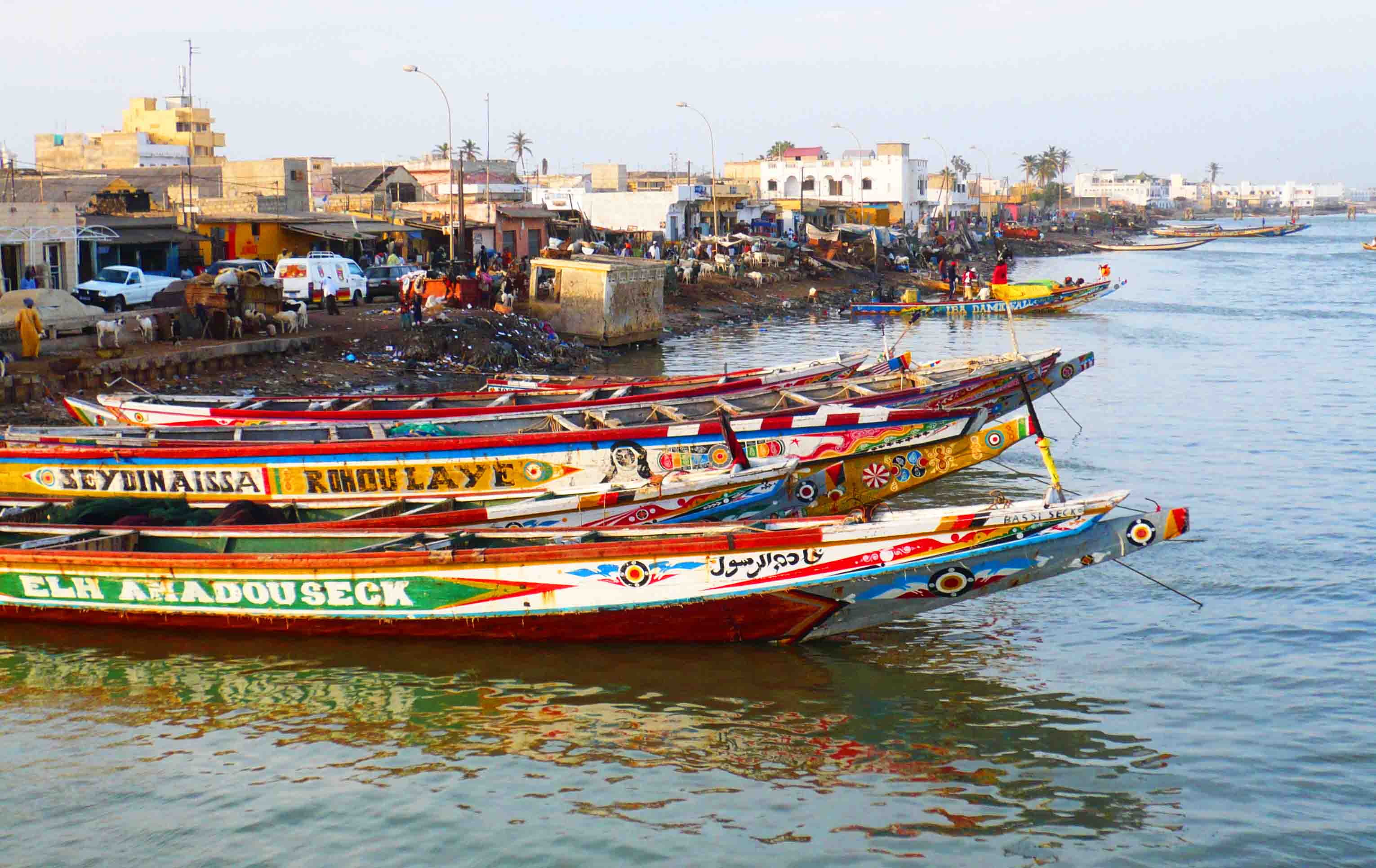
We camped at ZebraBar, a fairly luxurious campground about 20km south of St Louis on the ocean. Run by a Swiss family, it had cabins, a playground and lots of hot showers. Saint Louis is a depressing place. The buildings are falling apart. A few streets are paved, but most are simple dirt. Small troupes of bare-foot, filthy, little boys carry small plastic bowls filled with rice and beg bread. Most males wear football jerseys. But the women wear gorgeous, close-fitting print dresses that show shoulders, backs and some cleavage, and matching headscarves. It is a marked contrast to the dress in Mauritania, a much more conservative country. Some of the women are very pretty. Babies are carried on their mother’s back in a cloth sling. Two-wheel horse carts serve as taxis. Surprisingly, there is almost no street food, and coffee is dispensed from urns. There are several restaurants serving a full menu, but none of them have sidewalk tables. When I walked around on Saturday, there were several Koran schools in progress – all filled with rocking children sitting on the floor reading out loud from the Arabic texts.
On December 10, we had a fairly long drive to Lac Rose for a swim and bush camping. On the way we passed through Sahel with some large towns with great opportunities to observe the locals. One town was bustling with large crowds. The women look great – real eye candy – dressed in colourful, patterned, full-length dresses tight to their bodies and flare over their hips, usually with matching headscarves. A lot of shoulder, back and cleavage is displayed. Most wear a lot of gaudy costume jewelry and some makeup. Their hair is gorgeous with extensive braiding.
LAC ROSE. This shallow lagoon surrounded by dunes has a salt content about 10x that of the ocean and allows you to bob around like a cork. The first 20′ or so has a rose colour and a thick layer of dissolved salt, and on cloudless days when the sun is high, the lake supposedly also has a pink tinge. There were wells that allowed those who swam to rinse off as your skin gets very uncomfortable when it dries.

That night, we bush camped in a new housing development with the drumming noise of far-away parties and drove into Dakar on a 6-lane toll road. It was a Monday, a national holiday (Mohammed’s birthday), and all was quiet. We parked next to the port and walked into the central area of the city. I searched, to no avail, for a new battery for my computer (it is 2 years old and doesn’t hold a charge well).
DAKAR (pop 3 million)
The capital of Senegal spreads across the entire Cap Vert Peninsula. It is a city of contrasts with many homeless around the port, businessmen, scammers and hustlers.
Place de Independence. Surrounded by some nice colonial buildings, the square itself is rundown with few locals.
Musee Theodore Monod/IFAN. One of the best museums in West Africa, it provides a good overview of African art and culture and also contemporary art.
AFRICAN RENAISSANCE MONUMENT. This is the highest monument in the world at 52m. It was built by North Koreans (they have the most experience at building large monuments) in 2010 to commemorate the 50th anniversary of independence and consists of a man, a scantily dressed woman and a baby.
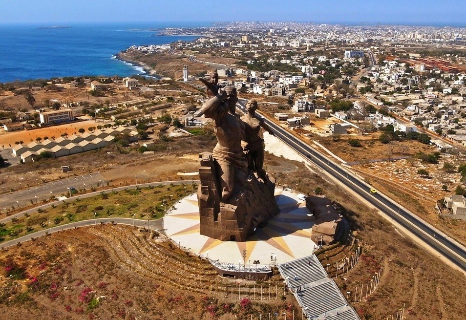
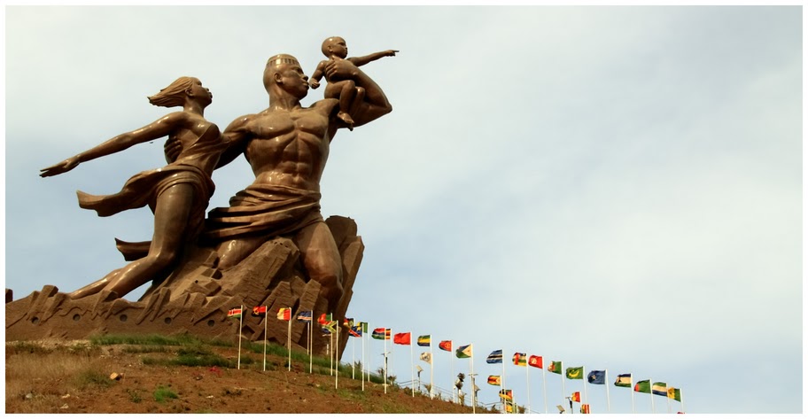

For 6,500CFA, two of us took the elevator to the top of the man’s head for great views. A guide toured us around the top, the 3rd and the 2nd floors (the museum). Besides portraits of the 4 Senegalese presidents, there was one of Martin Luther King (we have a dream) and Barack Obama (yes we can), the ancient wooden thrones of the past king and queen, 2 wooden carved “elephant tusks”, a fancy reception room and an unusual display of clay models of ethnic groups and what the artist thinks future humans would look like (very bizarre).
We bush camped at the Le Ngor Restaurant about 2 km north of the monument for 3 nights. It was a busy, very attractive place frequented by expats.


We camped and cooked in the parking lot, but there were toilets, swimming in the ocean, wi-fi, beer and good food. It was a few hundred meters from Point des Almadies, the most westerly point of Africa. Our second day in Dakar was spent with the tedious job of getting our Sierra Leone and Liberian visas.
ILE de GOREE. Ruled in succession by the Portuguese, Dutch, English and French, this Unesco World Heritage site has no roads, narrow alleyways, bougainvillea and colonial buildings with turned wooden balconies. It is an internationally famous symbol of the tragedy of the Atlantic slave trade. Though relatively few slaves were actually shipped from here, the island was a place where much of the trade was orchestrated. During the 18th and 19th centuries, many merchants built houses where they lived and worked in the upper story and held slaves in the lower floor. The Maison des Escalves is the last remaining 18th century building on the island and was allegedly used as a departure point for slaves.
It features the famous ‘doorway to nowhere” opening directly to the sea, but it was probably not used as ships could not access the door because of rocks (and a modern cement retaining wall).
The Castel, the southern tip of the island, has great views from the WWII gun batteries. Locals have squatted under the batteries and built shacks all over the summit. A modern incongruous monument is on top.
The 20-minute ferry to the island costs 5200CFA and has a tourist tax of 500 CFA.
Mosquitos are the worst we have seen so far on the trip. A political rally with the president passed the truck. The car was being mobbed, and security was very rough with many people.
After getting our Liberian visa in Dakar at about 1 pm on Dec 15, we left on our way to Mali – 647km to the border. The road followed the coast SE to Mbour with its fantastic, Disneyesque mosque – pink, 4 minarets, 2 towers flanking the entrance, and blue domes.
We then turned due east. The landscape continues to be Sahel/savannah – completely flat, heavily treed with scrub and wide varieties of trees, the most prominent being baobab –
enormous trunks and scanty, large, bulbous branches. At this time of year, just 2 months after the wet season, some have no leaves, some have a few, and some are completely leafed out. Waterholes and large shallow, alkaline lakes were common. Small plots of vegetables surround some. Areas of heavy scrub alternate with grassland, with dry tall grass and brush. Things are very dry, and it all looks ripe for a major bush fire. White Brahma cattle are more common than goats or sheep. The housing also changes to small compounds with concrete walls and eventually stick fences and classic thatched roofs over tiny square dwellings. At either end of most towns and villages, unfinished block homes are common, as if abandoned and serving no purpose.
There are frequent service stations, but just as common are “gas stations” dispensing fuel from litre whiskey bottles or occasionally jerry cans. Large stacks of firewood line the road to be loaded onto flatbed trucks.

After 5 hours and many pee breaks (someone has cystitis), we had gone about 350kms and bush camped. It was lovely to finally not have mosquitoes or flies, reflecting the dryness.
Determined to arrive at the Mali border that day, Steve had us moving at 5 am, with most sleeping until 7 and breakfast on the truck while on the move. The road was new pavement, and after 4 hours, we arrived at Tambacounda in Central Senegal, just NE of the east end of The Gambia (the trip doesn’t go here, sounds like one of the more dysfunctional countries in Africa). Tambacounda is a hot, dusty, road junction with routes to The Gambia, Mali (187 km from the Mali border) and Guinea. It is a depressing place with a menial little market, no bread to buy and a mediocre selection of vegetables and fruit. Instead of oranges, there was a yellow citrus with a tough-to-peel skin, lots of pulp, a sour taste and many seeds. I tried one and decided not to buy more, and then took 5 minutes to floss my teeth from all the pulp wedged everywhere. Troups of little dirty boys crowd the end of the truck, hoping we will deposit some food in their little buckets. These kids are everywhere, and I wonder if they are orphans left to fend for themselves.
The road changed to thin pavement with lots of potholes. The back window was left open, and a cloud of dust enveloped the inside. Those who had recently applied sunscreen and moisturizer became black-face. The 186 km to the border town of Kidria took another 4 hours and we queued behind a huge line of trucks. The Senagelese exit stamp took 3 hours as the guy labouriously hand wrote all the passport and visa information into a big ledger. He was surprised that New Zealand and Denmark were actual places. The truck carne was obtained and we crossed the Senegal River into Mali. It was a fatiguing day.
I have enticed some of our fellow travellers to play hearts and a few are keen on the finer points.
