
Chile & Easter Island Feb 29 – March 23, 2012
4300 km long and less than 200 km wide on average, Chile has 6534 km of coastline. Northern Chile is mostly the Atacama Desert, the driest desert in the world, with some places having never recorded rainfall. Central Chile with wide river valleys is the main agricultural area and contains the Lake District next to the Andes, and the south is part of Patagonia. Nitrates from the Atacama Desert funded early prosperity. Up to the 1920’s, haciendas controlled 80% of the land but agrarian reform distributed most of the land up to the 1970’s. With copper the cornerstone of the economy, in 1964, the government nationalized 50% of the US-owned mines. Chile weathered the recent economic crisis well and has virtually no deficit. It superficially resembles Europe but there is still a large income gap. One-third of its 16.6 million inhabitants live in Santiago. While most are Spanish mixed with indigenous groups, it has had major immigration from Germany, Britain, Ireland, France, Italy, Croatia and Palestine. Easter Island was annexed in 1888. Most noticeable are the lack of visible indigenous groups, significant obesity and a country much richer (touted as the 4th richest country in the world by Chileans [this is doubtful] and more expensive to travel in) than the countries so far visited. Most things look like home but there seems to be an undercurrent of poverty. Chilean Spanish is difficult to understand as they drop many letters from the end of words, especially s’s, speak in a rapid sing-song, and use a lot of slang.
Still travelling with the 3 German university students, I crossed into Chile over a 4900m pass in a 4WD and transferred to a bus for the 30-minute drive down to San Pedro de Atacama (pop 3200, elevation 2440), an oasis in the middle of the desert. 10 years ago there were 5 hotels here and now there are 100, with a huge number of restaurants and tour agencies, and it is a major stop on the gringo trail. Many skip the very northern part of Chili. San Pedro has narrow dirt streets lined with one-story buildings and adobe walls.
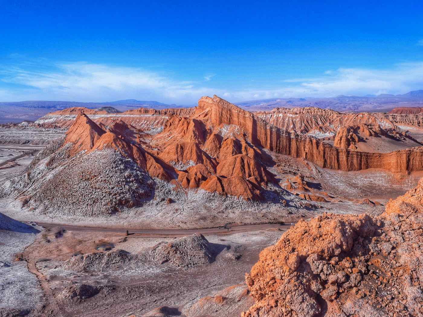
Every tour company offers the same tours – to the salt flats, geyser fields, sand boarding on the dunes, and lakes. I went to Valle de la Luna, a big area with spectacular eroded landscapes. Originally a salt flat, the area was uplifted by seismic activity. Two weeks before we arrived, there was a record rainstorm and the dry brown hills were transformed into a fairyland of salt-encrusted landscape producing a never-before-seen scene of white dusting, new watercourses and white river beds. We went to several lookouts, walked in a big sandstorm and watched the sunset over the desert.

That night I went to an astronomy show with 10 telescopes run by a Canadian from Hamilton.
This was the first day of the Atacama section of the four desert ultramarathons (the others are in the Sahara in southern Morocco – hottest, Gobi desert in Mongolia – windiest, and the Antarctic – coldest), all about 260kms long involving about a marathon a day carrying 9 kg packs over 6 days. There were runners in town from all over the world.
VALPARAISO (pop 276,000)
The 4 of us then boarded a bus for the 24-hour trip to Valparaiso on the coast just 120 km NW of Santiago. The majority of the trip was through the desolate country with zero plant life and only dirt and rocks, then cactus and scrub and finally trees and vineyards. Once a major port, Valparaiso, declined after building the Panama Canal but is still a Unesco World Heritage Site with multicoloured colonial houses climbing the hillside. It is famous for its many ascensores or elevators built in its heyday from 1883 to 1916 to get people up the cliff that separates downtown from the residential districts above. Saying goodbye to the German youngsters and after getting a dorm room in a hostel, I caught the metro out to Viña del Mar, a beach resort city 5 km north of V. The next day I went with a nice guy from Asheville, North Carolina to Pablo Neruda’s Valparaiso house, La Sebastiana, a 5 story building containing many of this Chilean poet’s eccentric purchases and collections over the years. It was quite interesting and had beautiful views of the city and harbour.
We then walked all over seeing the city with its great collection of graffiti art. It was a nice relaxing day. I have spent some time trying to obtain my air tickets to Easter Island and finally have them (leaving on March 17 for 6 days). It was much easier from Chile and cheaper (quoted $2200 in La Paz but here for $900). Hoping to see Neruda’s most outlandish house in Isla Negra, 80 km south of Valparaiso, I went to the bus terminal early but learned that like everything in Chile, it was closed on Monday, so had another easy day waiting for the night bus to Temuco, 675 km south of Santiago, a gateway city to the northern lake district. I have 12 days to explore this area before returning to Santiago to fly to Easter Island.
After arriving in Temuco, I caught the bus riding 3 hours to Melipuerco, the town on the south edge of NP Congillio, renowned for its large stands of monkey puzzle trees or araucaria. Having seen this very unusual tree before in Ronnings Garden on north Vancouver Island (he was a Norwegian who homesteaded there in 1910 and planted a fabulous garden with plants from all over the world), I was keen to see it in its natural habitat and in great numbers. Its name comes from the fact that it is covered with very spiny leaves preventing anything from climbing it. The only way to see it was with tour companies so for $80 hired a driver and guide (a young Chilean who has worked for a few years in Tofino and on Mt Washington, 20 minutes from my apartment). The big volcanoes here are Sierra Nevada and Lliama (3125m) and we drove for many kilometres past lava flows from its large eruptions in the 1850s, 1927 and 1957 (it last erupted in 2009).

The first trek was to the Mother, the 1800-year-old, 50 m tall, and 3 m diameter Araucaria Madre tree, the largest in the park. We then hiked several km up the Sierra Nevada trail to 2 lookouts with many monkey puzzle trees and great views of Conguillio Lake. I then caught the bus back to Temuco and another to Pucon, the next stop in my lake district adventure.
Pucon (pop 17,000), is touted as the adventure capital of Chile and sits on the shore of the large Lake Villarrica. It is very European-looking with a full range of hotels (many high-end), restaurants and tour companies. The highlight is Volcan Villarrica (2847m), visible from all over town with its constantly smoking summit and oscillating red glow at night. It last erupted in 1986 and its caldera is open making it active but with a low likelihood of erupting.
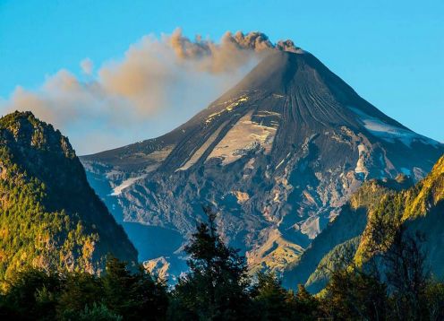
The only reasonable way to climb it (along with hundreds of others – 16,000 climb it each year) is guided by a tour company that outfits you with rigid boots, crampons, a full heavy nylon suit, an ice axe, and a helmet. Taking a ski lift part of the way up, the climb was relatively easy on snow and ice on a glacier and then volcanic rock to the top. The crater was narrow and deep and molten magna spectacularly shot up every few minutes. Pucon and everything below the ski lift were obscured by a dense carpet of clouds with all the surrounding volcanoes sticking up through it. The company provides a nylon bib to slide down the snow. The remaining few kilometres were on knee-saving scree. The next day I went white water rafting with 13 Chileans on a class 4 river just out of town. It was well worth it with many class 3 rapids and a few small waterfalls. I then went to NP Huerquehue to hike the 7km Los Lagos trail which switchbacks through a dense mature lenga forest to monkey puzzle trees surrounding a cluster of pristine lakes. The monkey puzzle trees are very unusual looking – straight, limbless trunks with a small umbrella-shaped crown of spiny branches at the top sticking above all the other trees. It was a cool, rainy day.

After an 11-hour bus to Santiago, I settled in to enjoy this big metropolitan city. Except for 2 small hills, it is completely flat and easy to walk. I stayed in a 7-bed dorm room in a great hostel.
After booking my bus to Buenos Aires, I caught the bus to Isla Negra, 2 hours by bus from Santiago, Pablo Neruda’s outlandish favourite house on the ocean. Filled with 3000 amazing artifacts, and built in the shape of a boat and a train, it was fascinating to see the eclectic collecting tastes of this famous Chilean poet. The house was packed with the bow sprints of boats, model boats, ships in a bottle, unusual furniture, hundreds of glass bottles, a wood horse and all his artifacts. Despite his fascination with the sea, he disliked going out in boats.
Returning to Santiago, I climbed Cerro San Christobal, a small mountain in the centre of the city for sunset and walked down and home in the dark. I devoted the next day to museums – the Museo Salvador Allende was not in the location in the Lonely Planet, I walked to the real location and it was closed for renovation, and a colonial mansion was also closed for renovation so after 2 hours of walking, I took the metro to the main cemetery which I knew would never be closed. An amazing collection of grand mausoleums, the only grave I knew was that of Salvador Allende who allegedly committed suicide in 1973 when he was replaced by the dictator, Pinochet. The Museum of Visual Arts had only 3 pieces in it. I climbed another small hill in the central area of town (significant smog obscured the surrounding hills), and walked through the main downtown area. A spectacular barbecue was held in the hostel. The best museum in town was also closed but I met John Walton’s son, John (who is married to a Chilean, works for Scotia Bank and has lived in Santiago for 11 years) for lunch.
EASTER ISLAND
On the 17th I caught a 5 1/2 hour flight to Easter Island or Rapa Nui (it is called the Navel of the World by its inhabitants and Isla de Pascua by Chileans). Discovered by a Dutch ship in 1722 on Easter Sunday and visited by Cook in 1774, it has the most astonishing story of ecological collapse on earth.
Triangular shaped with volcanoes on the 3 points (3 million, 2 million and 200,000 years old), its underwater area is 50x the 166 square km above water. There are at least 20 more small cones, the largest of which formed the quarry. It is the area of land furthest from any other land on earth – 2100 km from Pitcairn Island, 3700 km from Chile and 4000 from Tahiti (the only other place with a flight although LAN has just added a very cheap flight from Lima).
History. Settled in 400 AD by Polynesians who had spread across the South Pacific, it developed an incredible culture best known for erecting huge volcanic rock statues (moai) revering their rulers. This form of ancestor worship started in the 10th century. The island was covered with forests of an estimated 16 million palm trees. They had a slash-and-burn agricultural policy and the population exploded to 25,000 inhabitants. It is believed they also used the palms as rollers to move the moai from the quarry to the erection sites as they did not have the benefit of wheels. Palm nuts were also eaten by rats that came with the original inhabitants. Without natural enemies, the number of rats went out of control and their diet of nuts prevented the natural regrowth of the palms. Over a few centuries, they had cut down every tree on the island. As a result, they had no canoes to catch big fish and they were marooned on the island. A civil war between the five tribes resulted and their culture collapsed. Recent archaeological studies have concentrated on the 320 caves (many lava tubes) that have been discovered. In the 16th century, fish bones became smaller and were eventually replaced by the bones of birds. Originally the island had a huge bird population but eventually, 24 of the 25 bird species were wiped out. A vast increase in weapons (as evidenced by obsidian arrows and spearheads) was also coincident with the change in diet. Small statues were found with exposed ribs and big bellies indicating widespread starvation. One large cave on the coast was called “eat man cave” and it is thought that cannibalism also occurred. Caves became common places of habitation as they were more easily defended. The island of Eden turned into a hell.
Power centres were where the moai were erected but these were also the points of conflict. As a clan was defeated, its moai were pulled down and the eye sockets gouged out. Some tribes fared better than others because of location. For example, one cave had a good source of fresh water. Almost all moai were toppled in the civil war by the 17th century. Warriors dominated as they had control of the limited food and water supplies. Ancestor worship was over and a new political system called the birdman cult developed in the 18th century as a means of survival. To determine who had economic control, once per year, a race was held where one man per clan ran down the cliff and swam a mile to a small island to obtain an egg of the sooty tern. The first to get an egg earned the title of birdman and became the absolute ruler of the island. This solution was rather more democratic than heritage and resources were distributed based on this system. This brought the society back from the point of destruction. But it was short-lived as a few decades after the birdman cult started, a new threat arrived. In 1722 on Easter Day, a Dutch ship arrived and disaster struck. With the first encounter, a battle ensued. Over the next 50 years, more Europeans came and caves became a common site of refuge for the islanders. But the island had little to offer and few stayed. Diseases like syphilis killed thousands. When the population was down to 4000, 1500 natives were taken by slave traders to South America who subsequently returned with smallpox. By 1877, there were only 111 people on the island and now they were a mixture of many nationalities. It was called the “Island of the Dead”. It was not until 2003 that the population returned to that 4000 number, most descendants of the originals. It is the greatest story of collapse of a culture from environmental degradation on earth.
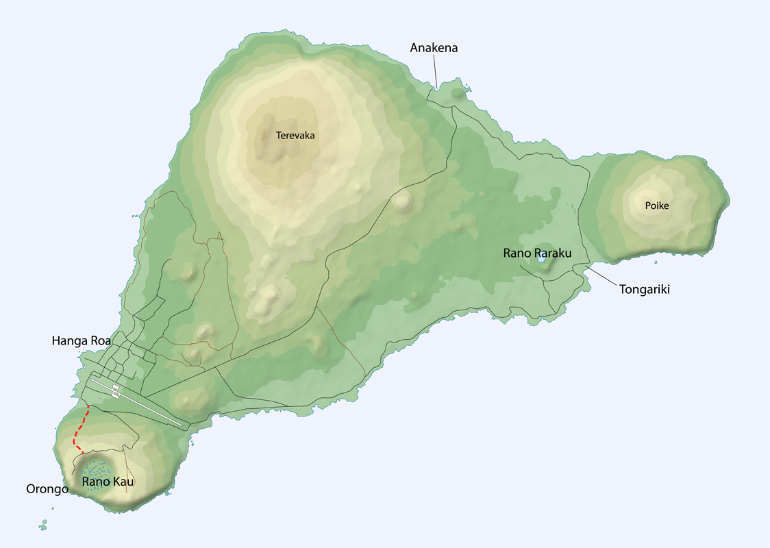
Day 1. Most people live in Hanga Roa on the SW shore with 4400 people. At 27 degrees south, the climate is subtropical with a few brief rains. Because of the limited gene pool and as incestuous relationships are not frowned upon, there are many genetic problems among the natives. Everyone is related to everyone else. Food especially in restaurants was exorbitant at least 3x mainland prices. My dorm room in a hostel however was only $14/night, it was in a great location on the west point of town with a 10-minute walk to the central area. I cooked all my meals here.
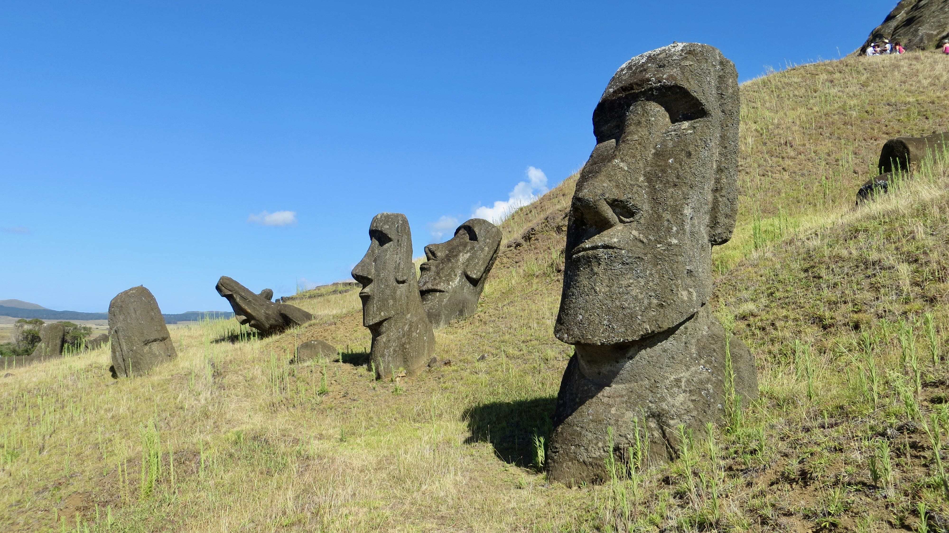
There are at least 890 moai, over ⅔ still in the quarry. With an average weight of 9.5 tons, the largest still in the quarry is over 100 tons. They all, except for size, are virtually identical (prominent brow, deep-set eyes, long nose with broad tip, prominent cheeks, thin lips, prominent chin, long ears, long arms and long fingers) and are made from the same type of volcanic rock with a yellowish tint and a red volcanic rock top knot. All were toppled during the civil war and many were scattered by a large tsunami in 1960. The first day I went to 9 AM mass in the Rapa Nui language (the church was packed with a big standing-only crowd flowing out the door), visited the excellent museum and had a long walk to climb the high point on the island, Terevaca at 507m (youngest north volcano). Just before the start of the way up are 7 standing moai, the only ones to face the ocean to the west. These were erected by Thor Heyerdahl. There was no crater on top, simply a long ridge in the howling wind.


It was a gorgeous walk down to the east through high grass, stands of big eucalyptus trees and many wild horses which are everywhere.
Day 2. With 2 young Chileans and a Korean, we walked along the west coast (bypassing all the moai on the west side of town, remnants of the original buildings, and 3 caves that are lava tubes) and north coast on a minimal trail for 8 hours to the best beach on the NE corner for a welcome swim (white sand surrounded by palm trees and with 8 standing moai) and then hitchhiked back to town. Through grass and lots of lava rock, it was wonderful along the cliffs with many wild horses, and several ahu (platforms for moai) and a few moai, all fallen.
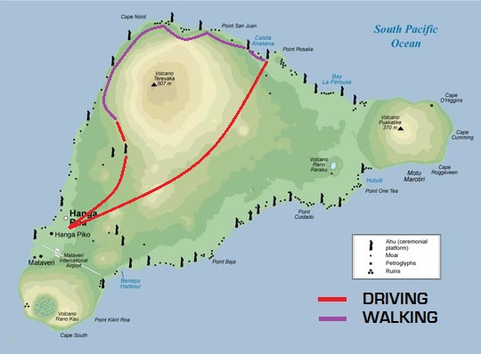
Day 3. I rented a car with 2 Korean guys and we went to the quarry where they obtained the red hats or top knots, saw the largest moai ever transported at 10 meters and 80 tons, visited some great petroglyphs, saw the spectacular display of 15 moai on the SE coast (only one with a hat, on a great ahu with a big inclined ramp and wings – erected in 1992-96 with help from Japan) and visited many ahu with fallen moai on the south coast. The next day, we got up to see the sunrise by the 15 moai, I climbed the southeast volcano (400m) alone and then walked cross-country to the quarry where all the moai were obtained.
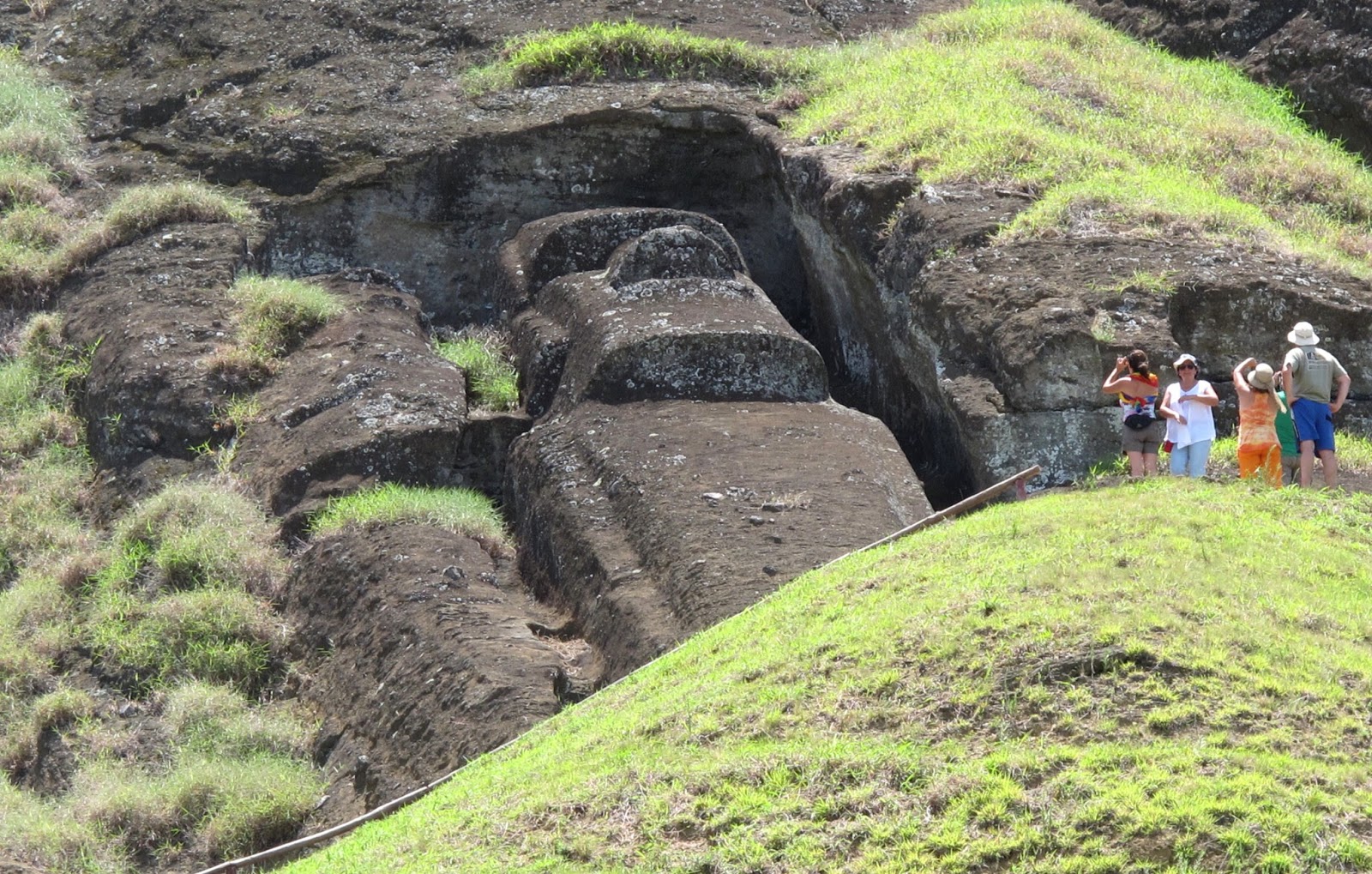
There were many lying and standing all over including in the large crater with a significant lake. I approached the quarry walking cross-country and entering it from the east. I then exited at the normal entrance much to the surprise of the women in the ticket booth.
That afternoon, I went snorkelling. It was a nice boat ride along the west shore to Motu Nui, an island on the SW tip that was the centre of the bird man cult. The visibility was unbelievable and there were many corals but few fish. The area available was minute around a small rock as the ocean was very active.
On my last full day, I climbed Orongo (410m), the volcano on the SW corner.
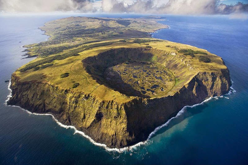
It has a huge perfectly round crater with a flat bottom and interspersed ponds. The south edge has a big gap where it is being eroded by the ocean. This is the site of a village used only for a few weeks of the year and is the only site on the island with religious significance. There are about 40 round houses built of slab rock on a tiny point on the edge of the crater and thousands of bas-relief petroglyphs.

The site was used to celebrate the bird man cult which replaced ancestral worship in the 15th century. The competition to be leader involved swimming to Motu Nui and trying to be the first to get a sooty tern egg. The last competition happened in 1867. It was a gorgeous walk down the edge of the cliff and I was able to follow the water all the way back to my hostel. On the way were spectacular lava formations and a cave with a few bird man paintings.
I’m confident that I had the best, most active time possible on Easter Island. I climbed all three volcanoes, descending each in unusual, trailless ways. The hike on the no trail NW coast was one of the most spectacular walks of my life. I walked to the quarry cross-country from the east volcano. Hitchhiking is a great way to get around. I would encourage anyone going here to do all these things – a much more authentic way to see the real island and few other tourists. Most simply rent vehicles and tour guides and see the highlight moia, walk around the town, and eat in restaurants.
On the 23rd, I caught my plane back to Santiago and then immediately got on the bus for a 24 plus hour trip to Buenos Aires via Mendoza.
Cost of Chile: 23 days, $2860 – $124.35/day. 500 Chilean pesos to the US dollar.
NEW EVIDENCE ON EASTER ISLAND
By Katie Hunt, CNN
September 14, 2024
Rapa Nui, known for its stone-carved heads, is at the southernmost point of the South Pacific’s Polynesian Triangle. Also called Easter Island, it’s one of the world’s remotest inhabited regions. Rapa Nui, also known as Easter Island, never experienced a ruinous population collapse, according to an analysis of ancient DNA from 15 former inhabitants of the remote island in the Pacific Ocean.
The analysis also suggested that inhabitants of the island, which lies about 3,700 kilometres (2,300 miles) from the South American mainland, reached the Americas in the 1300s — long before Christopher Columbus’ 1492 landing in the New World.
Settled by Polynesian seafarers 800 years ago, Rapa Nui, today part of Chile, has hundreds of monumental stone heads that echo the past. The island has long been a place of intrigue.
Some experts, such as geographer Jared Diamond in his 2005 book, “Collapse,” used Easter Island as a cautionary tale of how the exploitation of limited resources can result in catastrophic population decline, ecological devastation and the destruction of a society through infighting.
But that theory remains contentious, and other archaeological evidence suggests that Rapa Nui was home to a small but sustainable society.
The new analysis marks the first time scientists have used ancient DNA to address the question of whether Easter Island saw a self-inflicted societal collapse, helping to shed light on its mysterious past.
Easter Island genomes
To investigate Rapa Nui’s history, researchers sequenced the genomes of 15 former residents who lived on the island during the past 400 years. The remains are stored at the Musée de l’Homme, or Museum of Mankind, in Paris, part of the French National Museum of Natural History.
The researchers found no evidence of a genetic bottleneck corresponding to a steep drop in population, according to the study from the scientific journal Nature.
Instead, the island was home to a small population that steadily increased in size until the 1860s, the analysis suggested. At this point, the study noted, slave raiders from Peru forcibly removed one-third of the island’s population.
“There is definitely not a strong population collapse like it has been argued, a population collapse where 80% of the population or 90% of the population died,” said study coauthor J. Víctor Moreno-Mayar, an assistant professor of geogenetics at the University of Copenhagen’s Globe Institute in Denmark.
Rapa Nui is today a part of Chile and has long been a source of a fascination. An engraving depicts the giant statues, or moai, at the volcanic crater Rano Raraku.
The genomes also revealed that the Easter Islanders had exchanged genes with a Native American population, suggesting that the inhabitants crossed the ocean to South America somewhere between 1250 and 1430, ahead of Columbus’ arrival in the Americas — and well before Europeans reached Rapa Nui in 1722.
Around 6% to 11% of the individuals’ genomes can be traced to coastal South American ancestors, the study found, and the team’s analysis provided information about when these two groups met and had offspring. The authors estimated it took place 15 to 17 generations before that of the individuals studied.
Polynesian seafarers
The finding is not surprising. Oral histories and analysis of the DNA of present-day islanders suggested such ancestry, and remains of sweet potato, an import from South America, have been found on the island predating European contact, Moreno-Mayar said.
Some experts, and the wider public, have been reluctant to let go of cataclysmic stories about Easter Island, said Lisa Matisoo-Smith, a professor of biological anthropology at New Zealand’s University of Otago.
But the ancient genomes add to a growing body of evidence that the idea of a self-inflicted population collapse on Easter Island is a false narrative, said Matisoo-Smith, who wasn’t involved in the study.
“We know that the original Polynesian voyagers who discovered and settled Rapa Nui at least 800 years ago were among the greatest navigators and voyagers in the world,” she said in a statement shared by New Zealand’s Science Media Centre.
“Their ancestors had spent at least 3000 years living in an Oceanic environment. They sailed eastwards across thousands of kilometres of open ocean and found almost all habitable islands across the vast Pacific. It would be more surprising if they had not reached the coast of South America. These results do provide some intriguing evidence of the timing of that contact.”
Matisoo-Smith noted that scholars based in Pacific regions had questioned the narrative of ecocide and society collapse based on a range of archaeological evidence. “But now, we finally have ancient DNA evidence that directly addresses these two questions and perhaps will allow us to focus on a more realistic narrative of the history of this intriguing, yet actually rather typical, Polynesian island,” she said.
A study published in June, based on satellite imagery of land once used to grow food, reached a similar conclusion.
DNA analysis of human remains
The human remains used in the new DNA analysis had been collected by French scholar Alphonse Pinart in 1877 and Swiss anthropologist Alfred Métraux in 1935, according to the latest study, which cited museum archives.
Under what circumstances the remains were taken isn’t clear, the study said, but they were part of a wider trend of collecting from colonized regions during the late 19th and early 20th centuries.
The research team worked with Rapa Nui communities and government institutions to obtain consent for the study. The scientists said they hoped the results would help facilitate repatriation of the remains so that the individuals could be laid to rest on the island.
