
MT ROBSON PROVINCIAL PARK – BERG LAKE TRAIL
Mount Robson, at 3954m (12,972 ft), is the highest mountain in the Canadian Rockies. It was first climbed by Conrad Kain and party in 1913. The park was designated a UNESCO World Heritage Site in 1990. Possibly the premier backpacking trip in Canada, I have wanted to do it for many years. Campsites must be booked (1-800-689-9025) and are in demand in the summer. Most of the hikers were from northern Alberta and BC, along with a surprising number of Americans and Germans.
After hiking camp, I drove on one of the most spectacular roads in the world, the Icefields Parkway to the park. Visitor facilities are in the neighboring communities of Jasper, Tete Jaune Cashe and Valemount. Register at the Visitors Center and get your permit. All campsites, with a total of 97 camp tent pads, have food storage boxes, pit toilets (no toilet paper), and wash basins. Camp stoves are mandatory. Sleeping is not allowed in the shelters except in emergencies.
Hiking alone, my 50 liter pack was at its maximum. The trailhead is a kilometer from the Visitors Center and sleeping overnight is not allowed (although I did in my camper and escaped detection for once). I planned on walking the 21km to Berg Lake over 2 days, day hiking for 2 days and returning in 1 day. The trail follows the gorgeous, glacial silt laden Robson River, in the headwaters of the Fraser River. With no lake along its entire length, that silt is carried all the way to Georgia Strait (I kayaked around Gabriola, Valdez and Galiano in June and it was easily noticeable in the currents). Along the flat 4.5km to Kinney Lake, one meets a stream of day hikers. The Kinney Lake Campsite is at 7 km and has a shelter. Mt Robson creates its own micro climate and an interior rainforest of cedar and hemlock. Beyond Kinney Lake the trail enters the spectacular Valley of a Thousand Waterfalls. I camped my first night at Whitehorn (21 sites) at 11km.
The trail soon starts its 1800 foot climb up to Berg Lake. The many huge waterfalls are spectacular – the Falls of the Pool, White Falls and Emperor.
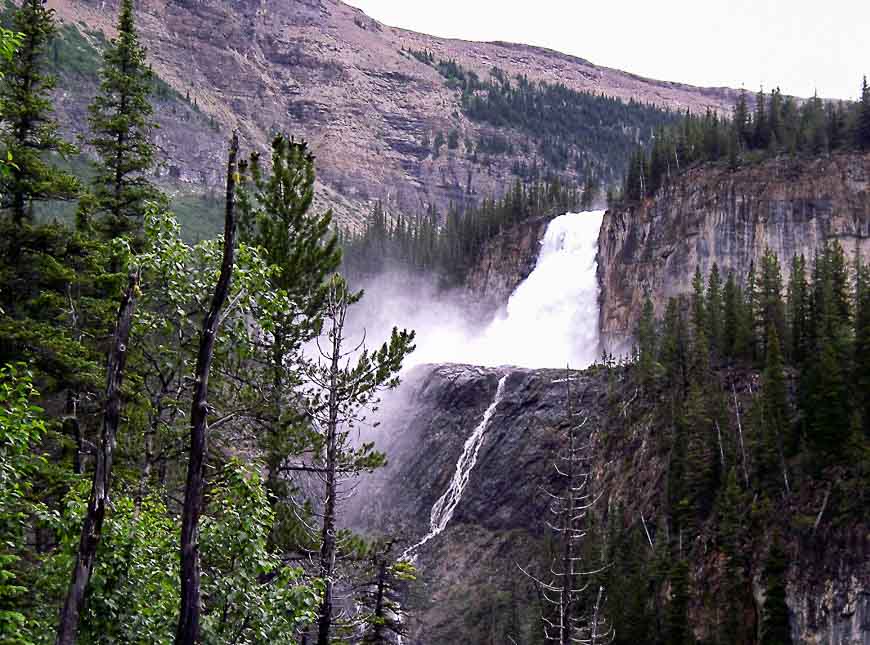

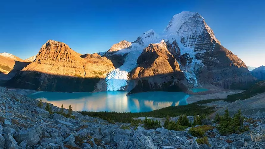
At the top of the climb at 16km is Emperor Falls campsite (16 tent pads) and at 19km, at the start of the lake, is Marmot campsite (7 tent pads). I was lucky to get a permit for the Berg Lake campsite at 21 km, with 26 tent pads and a “chalet”. The closed in shelter has large storage lockers, big tables and allows cooking inside. It is the premier place to camp. It sits across the lake, under the towering north face of Mt Robson with its two huge glaciers, Berg and Misti, spilling down the mountain and terminating in the lake. Ice calves off frequently producing loud roars that reverberate across the valley. Icebergs litter the lake. Rearguard Campsite (5 pads) at 22 km and Robson Pass Campsite (15 pads), at 23km are also available.
There are many day hikes available. The Hargreaves Lake Route continues to meet the Toboggan Falls Route. Above is a small non-limestone cave with 6 chambers. This trail can be continued to Mumm Basin with alpine lakes and great views. The premier day hike is to Snowbird Pass. The 11km trail climbs moraines and cliffs above the massive Robson Glacier. One passes a sign placed in 1913, now 1.5km from the present terminus of the glacier. The trail continues along a pretty boulder strewn creek though a meadow to eventually reach the saddle of the pass. On the other side of the Snowbird is a gigantic glacier that fills the entire valley. The hike requires a full day. I was surprised at all the people day hiking with no pack. They seem unaware of possible severe weather in the mountains.


The 7 day, 105km Moose River Route crosses Robson Pass to Adolphus Lake continuing on to the Jasper National Park trail system. Moose Pass returns you to Mt Robson Park and down the Moose River to Highway 16 near its confluence with the Fraser River.
This must be one of the most beautiful places in Canada and possibly the world. The trip has become the second favorite backpack of my life (after Havasu Canyon in Arizona). I walked out in a day and continued on my driving holiday through northern BC, the Yukon, and Alaska.
Section of Berg Lake Trail open to hikers

