
Happily we have arrived in Mexico. What a gorgeous place it is for beach lovers and people who don’t mind being lost, confused and overwhelmed with newness. We drove from Calexico over the border expecting at least a border guard and all we got was huge concrete arches, 8 lanes of traffic, sudden Spanish, and a bunch of people standing around in dark uniforms. The transition was unexpectedly uneventful, but wait… Mexico looked a lot different. The city of Mexicali was busy with people moving in all directions. Signs in Spanish – my dictionary and I couldn’t keep up. Traffic moved differently, kind of chaotic, and we were accosted by window washers and panhandlers at every red light. We even got our windshield washed – twice. It was dirty the first time. After driving around the block and not finding the expected big TOURIST CARD HERE! Sign, I took my biggest smile and most lost and confused expression, easy to do under the circumstances, and sought help from the “Border Guards”, one of whom spoke English. The immigration office was the building with the green letters back where we had come from. We drove around the block again, got into the wrong lane then into the right lane, parked in the middle of the road, were directed to a proper parking spot, got into the wrong lineup (for car registration not people) finally found, with the help of an official, a woman and a teenager who spoke English, the immigration office. With many smiles and mucho gracias we got our cards and were on our way. The officials didn’t even look into our camper. They barely glanced at it. We could have been smuggling millions of dollars into the country, or drugs, or illegal aliens. We must look like law-abiding young snowbirds (hatchlings).
We drove to San Felipe over a road that turned from freeway, to two-way traffic, to two-way with ruts, no shoulder and potholes big enough to swallow a Volkswagen. We made it to San Felipe by sunset and settled into a campground with playa (beach), palapas, a caretaker, bathrooms and showers. The latter two I recommend using in the dark although I did console myself with the notion that they are probably cleaner than the places we used in the US that have had hundreds of thousands of people using them. Here dirt is visible. There it exists in microscopic size. I’ll take my chances with a little sand. We hiked the beach every day and once climbed the mountain that blocks the north end of the beach. On top were two soldiers sleeping under camo netting and a gun was pulled on us. Instead of enjoying the view and a snack, we were gone in a second. We were later told that it is used by the army as a lookout for drug smugglers.
Vendors are everywhere, all the time. Everything is colorful and filled with sound. The vendors offer “good prices” and sell everything from t-shirts and sunglasses to ceramic sunflower sinks (which I loved by the way). On our walk the next day we found lots of property for sale and a new campo. A Canadian dog announced our heads peeking over the driveway wall and Alfredo, the caretaker, welcomed us right away. Only $10 a night with all amenities, security (we’re locked in at night), a stairway to our own clean and gorgeous beach, and a community of Canadians, an American, his Mexican family and two dogs. We’ve started our shell and glass collection already and will need a trailer to bring it home if we continue at this rate. Our Canadian neighbors gave us a snowbird flag to hang on our antenna and lots of information about our new community. They even offered to let us drive their newly restored 1969 VW around town for errands.
The days are never long enough. We can’t believe the incredible weather at home especially in Vancouver where Stanley Park was devastated by the huge winds. We aren’t tired of t-shirts and shorts yet. This morning we got up to watch the sunrise over the ocean, the pelicans fight over fish, a lone shrimp fisherman on the beach and a hummingbird who came and sat on the fence outside our door. With coffee I had my Spanish lesson with Alfredo and watched the tide come in. Later we’ll go to town to get some fresh shrimp – probably not in the VW as it’s not insured. I love this place!
On the roller coaster road to Puertocitas, we hiked through a forest of giant saguaro cactus festooned with turkey vultures. The hot springs in the rocks right on the ocean were sublime. They are underwater at high tide. After talking to some long time American expatriates, we decided to take the very rough road to Gonzaga, always a risk in the camper. After 7 1/2 hours to drive 75km along the spectacular coast, we arrived at the remote bay and its great sand beaches.
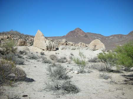
We fortunately met four young Americans who were nonstop fishermen. They invited us to go on a hike with them to Mission Santa María de los Ángeles was the last of the missions established by the Jesuits in Baja California in 1767. The site chosen was the Cochimí settlement of Cabujakaamung (“arroyo of crags”), west of Bahía San Luis Gonzaga near the Gulf of California coast, about 22 km east of Rancho Santa Inés, and south of Cataviña.
The mission site was visited by the Jesuit missionary explorers Ferdinand Konščak and Wenceslaus Linck. Victoriano Arnés founded the mission to replace the unsatisfactory site of Calamajué only months before the Jesuits were expelled from Baja California. After the establishment of Mission San Fernando Velicatá, Santa María was reduced to the status of a visita, or subordinate mission station. The visita was abandoned in 1818. Ruined structural walls and rock corrals survive at the site.
This mission is now called “Mission Impossible” because of the difficult access – unless you hike!
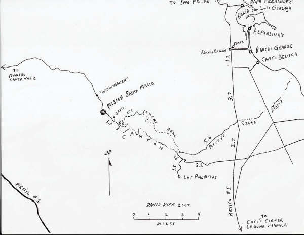
The map above is of the area around the mission. It shows the ‘oasis’ camp and the Camino Real location and ‘nearby’ highways Mex. 1 & 5, and Gonzaga Bay.
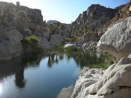
High above Gonzaga, this turned out to be one of the best day hikes of my life in a spectacular granite canyon with bright green water and many blue and green fan palms. With scrambles up and over boulders, we even had a short rock climb. The mission, also known as ‘mission impossible’ because of its remote location, had been abandoned 3 years after its construction in the late 1770’s. The adobe walls were melting away. The nearby springs with its ice-cold water were the basis for the oasis and its many palms. The return to the car was on an ancient Indian trail high above the canyon lined with boulders covered in petroglyphs.
When you Google the mission, there are many trip reports all using the terrible 4WD road from Santa Ynez – you must have a locking differential to make the trip, and you must return the same way.
The below map shows access from Bahia Gonzaga. Take K159, don’t take the left turn to Las Palmitas and park at the end, hike up the arroyo, see the mission and hike back down the El Camino Road. This sounds much easier than the drive and a lot more fun.

In Bahia Gonzaga, I had an exciting 6-hour kayak trip around the bay that took much longer than expected because of all the current.
Our next stop was Bahia Los Angeles on the Sea of Cortez. Called the poor man’s Galapagos, it has 15 islands many with bird colonies, and sea lions. After an intense four hours (and not one argument!), we got our two-man folding kayak put together. We paddled two mornings but the wind, which blows daily from November to March starting usually in the late morning, prevented much exploring. Barb also got tired of the nonstop forward stroke lessons and found the paddling fatiguing for her arm. Planning on leaving LA Bay, we stopped at the sea turtle research station and found a campground charging $2 per day and 2 nice couples, one from 100 Mile House and the other from Saltspring Island. We stayed for 4 more days. Ron had a chance to paddle around 7 of the islands out in the bay, and we climbed the big mountain behind the town to Mike’s cave with a new acquaintance from Aldergrove. It took 3 1/2 hours up with probably 3000’ elevation gain. We passed through incredible vegetation (boojum trees, flowers and cacti) and on the top was the old recluse’s camp in a cave.
We visited a wonderful mission, San Fransisco de Borja, built in the 1770s out of white rock. The 30-mile one-way gravel road passed through a spectacular desert full of boojums and cardon cactus. A 16-year-old Indian boy gave us a guided tour and Barb fell in love with him. The mission was located at a hot spring and cold spring and had orchards of palms and pomegranates.

Today, December 21, we are driving to Guerero Negro on the Pacific side. It is the site of the largest salt works in the world and Scammons Lagoon, a great whale-watching location. Because of the unlikelihood of whales this early, we’ll probably continue to Baja Sur driving through San Ignacio, Mulege, and staying at Bahia Concepcion for Christmas.
.